1854 Pharoah Map of the Rameswaram or Pamban Island in Southern India
PaumbemPassRamisseram-pharoah-1854$250.00

Title
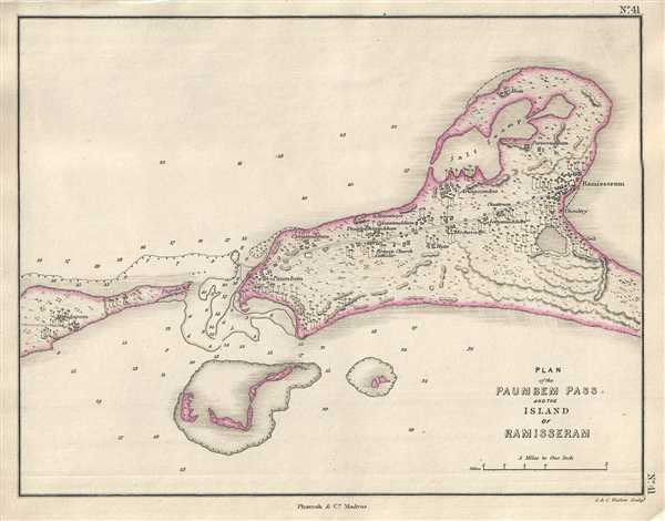
Plan of the Paumbem Pass and the Island of Ramisseram.
1854 (undated) 8.5 x 10.5 in (21.59 x 26.67 cm) 1 : 190080
1854 (undated) 8.5 x 10.5 in (21.59 x 26.67 cm) 1 : 190080
Description
This is a beautiful 1854 Pharoah and Company map or plan of the Pamban Pass and Rameswaram Island on the south east coast of the India. Rameswaram Island is part of the Ranganathapuram district of in the south Indian state of Tamil Nadu located between peninsular India and Sri Lanka. The map is beautifully detailed and notes the cities of Rameswaram and Pamban. It also notes important buildings, elevation, and fields and renders the region with numerous palm trees. Depth soundings are also noted.
The famous Adam’s Bridge or Rama Setu, a limestone ridge, lies between Rameswaram and Mannar Island in Sri Lanka. The bridge is believed to have been above water until the 15th century, until a cyclone in 1480 broke it and the channel deepened. According to the mythological epic Ramayana, the bridge was built by Hanuman and the Vanara (ape men) army of Lord Rama from Rameswaram to reach Lanka and rescue his wife Sita from the evil king Ravana. Today the island is a pilgrimage destination for many Hindus.
This map was engraved by J. and C. Walker and issued as plate no. 41 by Pharoah and Company in their 1854 Atlas of Southern India.
CartographerS
J. B. Pharoah (fl. c. 1838 – 1869) was a Madras, India, based bookseller and publisher of educational books and maps active in the middle of the 19th century. He maintained a bookshop on Mount Road. The form of which was a general emporium for European published work. They also published a weekly English language newspaper called The Athenaeum and Statesman (in 1864 renamed, The Athenaeum and Daily News). They also published the The Madras Quarterly Medical Journal and The Madras Journal of Literature and Science. More by this mapmaker...
John Walker (1787 - April 19, 1873) was a British map seller, engraver, lithographer, hydrographer, geographer, draughtsman, and publisher active in London during the 19th century. Walker published both nautical charts and geographical maps. His nautical work is particularly distinguished as he was an official hydrographer for the British East India Company, a position, incidentally, also held by his father of the same name. Walker's maps, mostly published after 1827, were primarily produced with his brothers Charles Walker and Alexander Walker under the imprint J. and C. Walker. Among their joint projects are more than 200 maps for the influential Society for the Diffusion of Useful Knowledge Atlas (SDUK). In addition they published numerous charts for James Horsburgh and the British Admiralty Hydrographic Office, including Belcher's important map of Hong Kong and Carless' exploratory map of Karachi. The J. and C. Walker firm continued to publish after both Walkers died in the 1870s. Learn More...
Source
Pharoah and Company, An Atlas of the Southern Part of India including Plans of all the Principal Towns and Cantonments, reduced from the Grand Trigonometrical Survey of India shewing also The Tenasserim Provinces, (Madras) 1854.
The Pharoah and Company Atlas of Southern India was published around 1854. The medium format 4to atlas contained some 70 maps focusing on the southern part of Indian and the Tanasserium Province, or Burma. The atlas was engraved an printed in London by J. and C. Walker, but seems to have been issued only in Madras, India, by J. B. Pharoah and Company. The atlas claims to have been "reduced from the Grand Trigonometrical Survey of India," and, in fact the survey did provide a framework for the atlas, but little of the actual cartographic detail. The atlas is rather novel in that it has universal scale of 16 miles to the inch (1 : 1013760) for most of its regional maps. In addition to its regional maps, the atlas also contained 21city plans. These plans are some of the only obtainable mid-195h century maps of many South Indian cities. It also contained a rare map of Singapore.
Condition
Very good. Minor foxing.
References
OCLC: 711966869.