This copy is copyright protected.
Copyright © 2025 Geographicus Rare Antique Maps
1848 Morris and Melish Wall Map of Pennsylvania
Pennsylvania-barnes-1848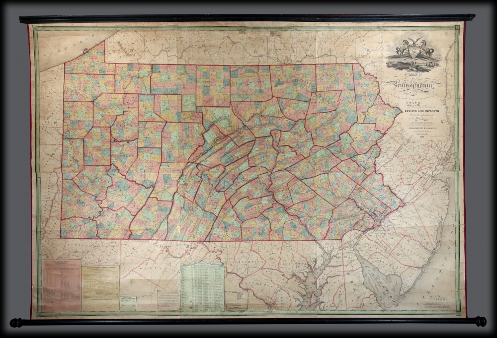

John Melish (June 13, 1771 - 1822) was an early 19th century American writer, publisher and mapmaker based at 209 Chestnut Street, Philadelphia. Many historians consider John Melish to be the first truly great American commercial cartographer and responsible for some of the most influential maps in the history of North America. Melish was born in Scotland in 1771. As a young man he apprenticed to a Glasgow cotton merchant and in this capacity visited America no less than four times between 1798 and 1809. In 1806 Melish attempted to create his own cotton important-export company based in Glasgow, Scotland and Savannah, Georgia. Unfortunately, deteriorating relations between the United States and Great Britain resulted in the 1807 trade embargo, which all but destroyed Melish's fledgling company. In 1811 Melish finally left Scotland to permanently relocate in Philadelphia. Melish had never been truly satisfied with the quality of travel writing available regarding the new republic and so, in 1812, published his own contribution to the genre. Melish based his first major publication, the cartographically rich, Travels in the United States of America in the Years 1806 & 1807, and 1809, 1810 and 1811, on the copious notes taken during his own travels as a cotton merchant. Travels enjoyed an immediate success and even caught the eye of Thomas Jefferson, then President, who sent copies of the work to friends in France and Italy. Partially in an attempt to illustrate his own travels and partly in response to a general need for good cartographic materials, Melish turned to map publishing. By 1814 he was styling himself as a "Geographer and Map Seller" and had published several independent maps, geographies and gazetteers. Melish's most important work is most likely his iconic representation of the United States first published in 1816, Map of the United States with the contiguous British and Spanish Possessions. This visionary large format map was the first American commercial map to show the United States extending from coast-to-coast in a remarkably prescient expression of the Doctrine of Manifest Destiny. Melish died suddenly of unknown causes in December of 1822. He is buried in Philadelphia. (Carter, E. C., Surveying the Record, pages 40 - 49. Ristow, W., American Maps and Map Makers, pages 110-115. 143, 154, 166-168, 191, 246, 281, 446. Wolfgang, M.E., "John Melish: An Early American Demographer." Pennsylvania Magazine 82 (1958): pages 65-81.) More by this mapmaker...
William Ellis Morris (January 29, 1812 - October 15, 1875) was a Pennsylvania based civil engineer and railroad executive active in the mid-19th century. Little is known of Morris' education, but earlier in his career as a civil engineer he was employed to plan the Portage Railroad link over the Pennsylvania's Allegheny Mountains. The curious project of the Portage Railroad involved a scheme to use a locomotive to hall barges up one side of the mountain range so that they could drift down the opposite side. He later ran the Germantown-Norristown Railroad Company and subsequently the New York's Long Island Railroad - which from a point of near bankruptcy he developed into a world class transportation network. His cartographic work seems limited to his revision of Melish's map of Pennsylvania in1848. Learn More...
Rufus L. Barnes (fl. c. 1840 - 1867) was an American map publisher and seller based in Philadelphia during the early to mid-19th century. Barnes opened a map shop in Philadelphia in 1840 from which issued numerous maps on his account as well as reselling the work of others. Rufus' manuscript ledger, which is preserved in the Newbury Library, reveals connections to most of the prominent map publishers and cartographers of his period, including Robert Pearsall Smith, C.K. Stone, A.R.Z. Dawson, A. Pomeroy & Co., D.J. Lake and Company, Henry F. Walling, S. Willard Treat, John Homer French, R.S. Taintor, Jr. and Co., William Otis Shearer, surveyor Silas N. Beers, engravers Worley and Bracher, A.D. Ellis, Green and Wilbur, and O.W. Gray and Son. His work was used by both sides during the American Civil War and included some of the best Pennsylvania county maps available at the time. Barnes notably partnered with William Ellis Morris to reissue John Melish's important wall map of Pennsylvania in 1848. Barnes sold his business to his assistant John L. Smith in 1867. Learn More...
Copyright © 2025 Geographicus Rare Antique Maps | Geographicus Rare Antique Maps
This copy is copyright protected.
Copyright © 2025 Geographicus Rare Antique Maps