This item has been sold, but you can get on the Waitlist to be notified if another example becomes available, or purchase a digital scan.
1877 Ruger and Anton Map of the Battlefield of Perryville, Kentucky
Perryville-ruger-1877$87.50

Title
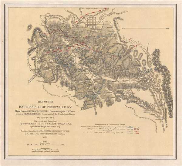
Map of the Battlefield of Perryville KY.
1877 (dated) 11.75 x 13 in (29.845 x 33.02 cm) 1 : 48000
1877 (dated) 11.75 x 13 in (29.845 x 33.02 cm) 1 : 48000
Description
Recognized as being among the most important historic maps of Kentucky, this is an 1877 Edward Ruger and Anton Kilp map of the battlefield in the vicinity of Perryville, Kentucky. The map depicts the region from the Chaplin River to the proposed railroad from Lebanon to Stanford (we say proposed because the railroad had not been built when the map was made) and from Perryville to an open ridge west of town. The largest Civil War battle fought in Kentucky, the battle took place on October 8, 1862, and was fought in the Chaplin Hills west of Perryville. Also known as the Battle for Kentucky, it is considered to be a strategic Union victory, since Confederate General Braxton Bragg withdrew to Tennessee soon afterward. Ruger and Kilp , who surveyed and compiled the work, employed an incredible amount of detail and illustrate not only the positions of the opposing armies at the beginning of the engagement, but how the battle progressed. By using different color schemes, Ruger and Kilp differentiate between the positions of different units on different days, allowing for the viewer to get some understanding of the flow of battle. The few roads in the area are also illustrated, along with creeks, rivers, and various landmarks, all of which are labeled.
This map was surveyed and compiled by Edward Ruger and Anton Kilp and published in 1877.
This map was surveyed and compiled by Edward Ruger and Anton Kilp and published in 1877.
CartographerS
Edward Ruger (September 16, 1834 - May 18, 1918) was an American engineer and soldier. Born in Lima, New York, Ruger (one of nine children) was the second son and third child of Thomas Jefferson and Maria (Hutchins) Ruger. Ruger's parents moved to several different towns within the state of New York during his youth, and at one point attended public school in Marcellus, New York. In 1844, Ruger's family moved to Janesville, Wisconsin, where he father served as a home missionary of the Protestant Episcopal church. In Janesville, Ruger attended public school and then the Janesville Academy, where his father was the first principal. However, Ruger only formally attended school for the three winter months of the year, with his father administering his schoolwork during the rest of the year so Edward could work on the family farm. Edward Ruger's father was an accomplished mathematician, which led the younger Ruger to study mathematics and a love of civil engineering and surveying. In 1857, Ruger opened a surveying office in Janesville, bringing with him experience surveying land for the United States, subdividing sections, and making preliminary and locating surveys for railroads and their construction. Ruger was elected city engineer of Janesville in 1859, and county surveyor of Rock County in 1860. He gave up these posts in 1861 when he enlisted in the Union Army and was enrolled as captain of Company A, Thirteenth Wisconsin Volunteer Infantry. He and his regiment left Janesville in January 1862 and moved their way south to Kansas, eventually to Fort Riley. After leaving Fort Riley, he and his regiment were given the task of rebuilding bridges that had been destroyed by Confederate troops. Eventually, Ruger was named a topographical engineer and served in such capacity on the staffs of Major General Lovell H. Rausseau and Major General George H. Thomas. When he joined General Thomas's staff, he was placed in the position of superintendent of the topographical engineer's office of the Army of the Cumberland, a post he kept until 1869. He made surveys and drew maps of the operations of the Army of the Cumberland during the war and the operations of the Armies of the Tennessee and Ohio during the Atlanta Campaign. When Ruger returned to Janesville after leaving the Army, he again opened a civil engineering and surveying office. Beginning in 1874, he was almost completely engaged in hydraulic engineering, receiving contracts in that field from twenty-three different states. Ruger married Sarah B. Wright on August 23, 1862 in Janesville during a thirty-day leave from the Army. He and Sarah had two sons, Frank and Harry. More by this mapmaker...
Anton Kilp (18-- - 1876) was a German-American cartographer who fought in the American Civil War. Kilp and his wife Franciska fled Germany in 1849 and came to the United States. He joined the Union army and reached the rank of Captain before the end of the war. He served mainly as a cartographer and as an aide to General Peter Osterhaus, another German refugee. He and his wife moved to Washington, D.C. after the war, where Kilp found a job as a cartographer with the U.S. Land Office, where he worked until his death. The Kilps had at least two daughters, Mim and Pauline. Learn More...
Condition
Very good. Even overall toning. Closed margin tear professionally repaired on verso. Blank on verso.
References
LOC G3954.P45S5 1862 .R8. OCLC 43788108.