This item has been sold, but you can get on the Waitlist to be notified if another example becomes available, or purchase a digital scan.
1679 Cantelli / De Rossi Map of Ancient Persia
Persia-cantellirossi-1679$450.00

Title
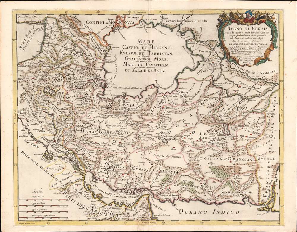
Regno di Persia con le notitie delle Provincie Antiche, che più probabilmente corrispondono alle Divisioni moderne d'esso Regno.
1679 (dated) 17.5 x 22 in (44.45 x 55.88 cm) 1 : 6500000
1679 (dated) 17.5 x 22 in (44.45 x 55.88 cm) 1 : 6500000
Description
This is a rare 1682 Cantelli da Vignola map of the Kingdom of Persia, incorporating modern day Iraq, Iran, Afghanistan and Uzbekistan. The map is unusual in its depiction of an eastern border to the Persian empire, here bordering the Mogul Empire. The map overall is notable for Cantelli's attempt to reconcile conflicting classical information of what was an essentially unfamiliar region, with what was at the time up-to-date geographical data. Cantelli synthesizes a variety of travel accounts and early maps, including those of Pietro della Valle (1586 - 1652), and Adam Olearius (1603 - 1671). Throughout the map, contemporary place names are printed alongside historical names, or those used by other peoples: for example, the name for the Caspian Sea is given in Latin, as well as transliterated Russian and Arabic, from the local name.
Beginning to Correct the Caspian
Almost all maps of this region produced in the 16th and 17th centuries followed the model of Claudius Ptolemy in showing the Caspian Sea as oval-shaped, widest on its east-west axis with the ancient Oxus, or Amu Darya river, flowing into its southeast quarter. The first map to correct this was that of Adam Olearius (1603 - 1671), whose 1647 map much more accurately mapped the Caspian's western shore, and was first to diverge from the Ptolemaic oval form. Cantelli's revision adds more detail to the Oxus river and what may be the Syr Darya, suggesting the eastern extent of the Caspian as shown here may actually be the shores of the Aral Sea. The Turkic tribal population surrounding the Caspian and Aral regions were notoriously aggressive to outsiders, and Europeans would remain ignorant of the true form of the Caspian Sea until well into the 18th century. It is very possible that the early, wide depiction of the Caspian represented a conflation of the Caspian and the Aral Seas. The ancient connection of the Oxus/Amu Darya to the Caspian would tend to support this contention, as that river actually did empty into the Aral. (Although for brief historical periods, the river was actually diverted to the Caspian with a dam.)The Persian Gulf
The Persian Gulf (shown as 'Golfo di Bassora' and 'Golfo d'Elcatif') is presented much smaller than fact, but improves on the detail over most contemporary maps. Bahrain is named (both a city on the mainland, 'Bahruin,' and an island, 'Baeren I. 'The Engraving
Cantelli’s maps, notably their cartouches, were some of the most attractively engraved of the later 17th century. The present map is no exception: a superbly executed copperplate engraving, the work of German engraver Giorgio Widman, whose imprint appears in the lower left. The map is distinctive in its hachured coastlines, pictorially represented mountains and forests, and clear elegant typography. The cartouche is surmounted with the bust of a Persian emperor, possibly Shah Abbas, and decorated with bows, arrows, spears, and other arms emphasizing the presumably warlike nature of the Shah's empire.Publication History and Census
This map was drawn by Cantelli, and engraved in Rome by Giorgio Widman for De Rossi's publishing house. It was probably issued as a separate until the publication of De Rossi's Mercurio Geografico in 1688. We count fifteen examples of the Mercurio Geografico in institutional collections. The separate map appears catalogued only by the Bibliotheque National de France, and the Biblioteca Nacional de Espana.CartographerS
Giovanni Giacomo de Rossi (1627 - 1691) was an Italian engraver and printer, active in Rome during the second half of the 17th century. His father, Giuseppe de Rossi (1570 - 1639), was the founder of the most important and active printing press of the 17th century in Rome. The printing press was begun in 1633, by Giuseppe de Rossi, and it passed firstly to Giovanni Giacomo and to his brother Giandomenico (1619 - 1653), and then later to Lorenzo Filippo (1682-?), then Domenico de Rossi (1659 - 1730). Giovanni Giacomo de Rossi was most active between 1638 and 1691 and was to take the company to the height of its success. The artists that he printed the etchings for included Giovanni Benedetto Castiglione (1609 - 1665), Pietro Testa (1612-1650), and Giovan Francesco Grimaldi (1606 – 1680). Cartographically he is best known for producing the maps of Giacomo Cantelli da Vignola and publishing them in his c. 1683 Mercurio Geografico. In 1738 the firm became the Calcografia Camerale, from 1870 until 1945 the Regia Calcografica, and today it is known as the Calcografia Nazionale. The Calcografia Nazionale holds is one of the finest collections of early printing plates and prints in the world. More by this mapmaker...
Giacomo Cantelli da Vignola (February 22, 1643 - November 30, 1695) was an important Italian cartographer and engraver active in 17th century Italy. Cantelli was born in Montorsello, near Vignola, Italy to a prominent local family. After studying literature at the University of Bologna, Cantelli took a position as secretary to the Marquis Obizzi de Ferrara. Eventually Cantelli relocated to Venice where he developed an interest in cartography. He later traveled to Paris in the company of the French ambassador where became acquainted with the French cartographer Guillaume Sanson, as well as his contemporaries Jacques-Andre Duval and Michel-Antoin Baudrand. It was most likely the influence of these innovative French cartographers that inspired Cantelli's careful and meticulous approach, in which he based his cartography not just on earlier maps, but also very much in the French style upon accounts written by travelers and merchants regarding actual travel to foreign lands. Back in Italy, Cantelli took service with Count Rinieri Marescotti, with whom he traveled extensively throughout Italy, becoming in the process acquainted with the Italian publisher Giovanni Giacomo de Rossi. It is with Rossi that Cantelli began officially publishing his maps. The earliest maps to bear the Cantelli-Rossi imprint date to 1672 and detail the Holy Land, Persia, and the Ottoman Empire. Around 1680 the duo also began to publish the Mercurio Geografico, a large format atlas illustrating all parts of the world in a splendid Italian baroque detail defined by elaborate finely engraved cartouche work, high quality paper, bold Roman lettering, and dark rich inks. Some have compared his style go that of Giovanni Antonio Magini, another Italian cartographer of the previous generation. Cantelli da Vignola in fact pioneered the Italian style of fine bold engraving that would eventually be embraced and expanded upon by Vincenzo Coronelli. His work drew the attention of Pope Innocent XI and Reggio Francesco II d'Este, the Duke of Modena, both of whom offered him a position as court geographer. Cantelli chose to work with the Duke of Modena, in the service of whom he produced numerous maps and well as two large globes. He died in Modena in November 1695. Learn More...
Giorgio Widman (fl. 1672 to 1682) was a celebrated map and lettering engraver, who worked primarily with the De Rossi publishing house. He is perhaps best known for having executed the lettering of Giovanni Battista Falda's superb 1675 map of Rome. Learn More...
Source
Rossi, G. G., Mercurio Geografico, (Rome) 1688.
Condition
Very good. Mended tear just left of bottom centerfold with very slight loss; else a very attractive example.
References
Rumsey 11438.152. OCLC 495058158. Alai, C., General Maps of Persia 1477-1925, E. 63.