Digital Image: 1705 Adriaan Reland Map of the Persian Empire
Persia-reland-1705_d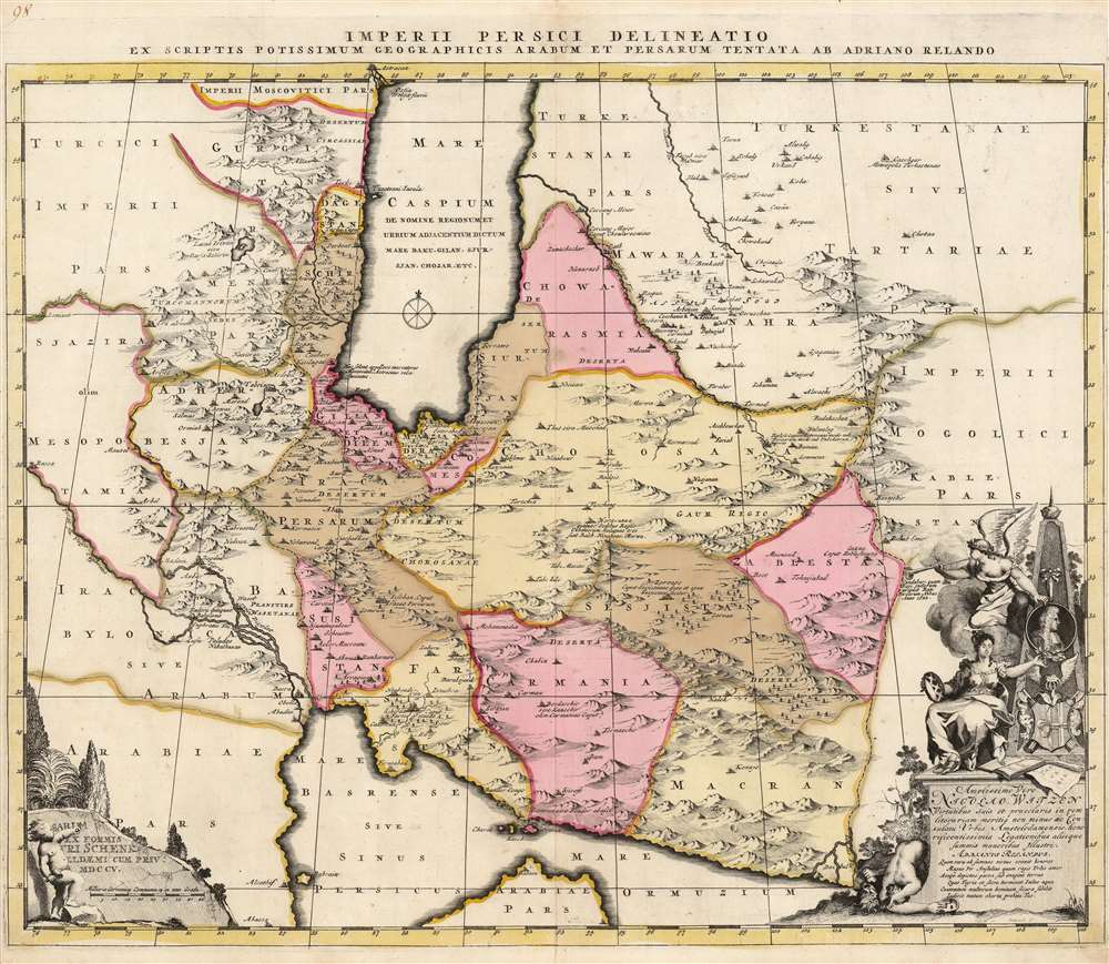

Title
Imperii Persici delineatio ex scriptis potissimum geographicis Arabum et Persarum tentata ab Adriano Relando.
1705 (dated) 18.75 x 22.25 in (47.625 x 56.515 cm) 1 : 5600000
1705 (dated) 18.75 x 22.25 in (47.625 x 56.515 cm) 1 : 5600000
Description
FOR THE ORIGINAL ANTIQUE MAP, WITH HISTORICAL ANALYSIS, CLICK HERE.
Digital Map Information
Geographicus maintains an archive of high-resolution rare map scans. We scan our maps at 300 DPI or higher, with newer images being 600 DPI, (either TIFF or JPEG, depending on when the scan was done) which is most cases in suitable for enlargement and printing.
Delivery
Once you purchase our digital scan service, you will receive a download link via email - usually within seconds. Digital orders are delivered as ZIP files, an industry standard file compression protocol that any computer should be able to unpack. Some of our files are very large, and can take some time to download. Most files are saved into your computer's 'Downloads' folder. All delivery is electronic. No physical product is shipped.
Credit and Scope of Use
You can use your digial image any way you want! Our digital images are unrestricted by copyright and can be used, modified, and published freely. The textual description that accompanies the original antique map is not included in the sale of digital images and remains protected by copyright. That said, we put significant care and effort into scanning and editing these maps, and we’d appreciate a credit when possible. Should you wish to credit us, please use the following credit line:
Courtesy of Geographicus Rare Antique Maps (http://www.geographicus.com).
How Large Can I Print?
In general, at 300 DPI, you should at least be able to double the size of the actual image, more so with our 600 DPI images. So, if the original was 10 x 12 inches, you can print at 20 x 24 inches, without quality loss. If your display requirements can accommodate some loss in image quality, you can make it even larger. That being said, no quality of scan will allow you to blow up at 10 x 12 inch map to wall size without significant quality loss. For more information, it is best consult a printer or reprographics specialist.
Refunds
If the high resolution image you ordered is unavailable, we will fully refund your purchase. Otherwise, digital images scans are a service, not a tangible product, and cannot be returned or refunded once the download link is used.
Cartographer S
Petrus Schenk (Pieter Schenck) the Elder (December 26, 1660 - 1711) was a Dutch engraver, globe maker, and map publisher active in Amsterdam and Leipzig in the latter half of the 17th century. Schenk, was born in Elberfield, Germany. He moved in Amsterdam in 1675, becoming the apprentice to Gerard Valk (Valck). In 1687, Schenk married Agatha Valk, Gerard Valk's sister and went into partnership with his brother-in-law under the imprint of 'Valk and Schenk'. Initially they focused on maps and atlases, acquiring the map plates of Jan Jansson and Jodocus Hondius in 1694. Later, in 1701 they moved into the former Hondius offices where they began producing globes. Valk and Schenk quickly became known for producing the best globes in the Netherlands, a business on which they held a near monopoly for nearly 50 years. Schenk's three sons, Pieter Schenk the Younger, Jan Schenk, and Leonard Schenk, all became engravers in their own right. Pieter Schenk the Younger inherited the business and ran his father's shop in Leipzig. His daughter, Maria Schenk, married Leonard Valk, the son of Gerard Valk, and continued to run the Valk and Schenk map engraving workshop in Amsterdam. More by this mapmaker...
Adriaan Reland (July 17, 1676 - February 5, 1718) was a Dutch orientalist scholar, cartographer and Philologist. Despite never having personally traveled beyond the Netherlands, Reland's work contributed materially to European understanding of Asian linguistics and cartography. His father was a minister; his elder brother a Haarlem lawyer. At 17 he began study of theology and philosophy at University of Utrecht; an early interest in Biblical languages led to a study in Arabic. By the time of his gaining a professorship in 1699 he was fluent in Arabic, Hebrew, and other Semitic languages, and would become Professor of Oriental Languages in 1701. He became famous for his early work in the field of comparative linguistics, and the comparative study of Persian myths with respecrt to the Old Testament. He was the only important scholar of the Persian language during his lifetime. By 1708, his linguistic work had reached beyond comparative Biblical languages, to embrace the study of Malay language and the languages of the Western Pacific as recorded by Schouten and Le Maire. Reland produced in 1705 De religione Mohammedica libri duo , the first objective survey of Islamic belefs and practices.
Reland's cartographic output included a 1705 map of Persia, a 1715 map of Japan, a 1715 map of Palestine. He was notable for his reliance on cartographic sources native to the regions depicted, Persian sources informing his Persia map, Japanese sources informing his Japan. He died young, of smallpox in 1718, at the age of 41. Learn More...
Source
Schenk, P., Atlas Contractus, (Amsterdam), 1705.