This item has been sold, but you can get on the Waitlist to be notified if another example becomes available, or purchase a digital scan.
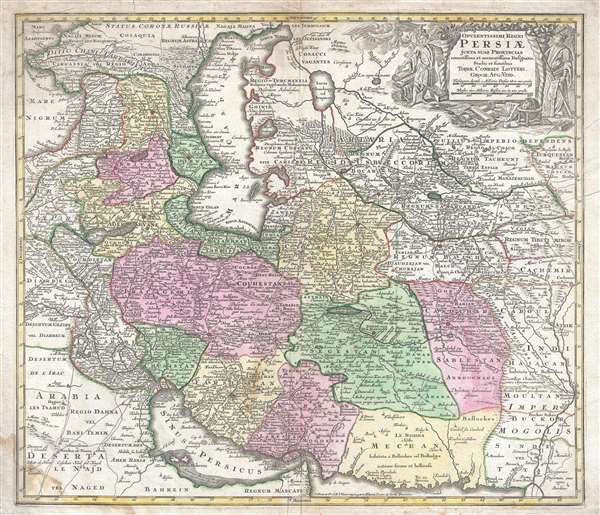
1750 Lotter Map of Persia, the Caspian Sea, and the Caucasus
Persiae-lotter-1750
Title
1750 (undated) 20.25 x 23.5 in (51.435 x 59.69 cm) 1 : 5300000
Description
Shah Nader and an new Persian Empire
This was a very volatile era in the history of Persia, with Peter the Great, the Czar of Russia, launching the Russo-Persian War in 1722 and capturing a large portion of Iran's territory in the Caucasus. Also, in 1722, an Afghan army invaded Iran and laid siege to Isfahan, eventually taking the city. By the 1740s, a new Iranian warlord, Nader Shah, had defeated the Afghans and the Ottomans and negotiated the Russian withdrawal from the Caucasus. He had also restored the monarchy. Nader was made King of Iran in 1736. His empire would eventually include most of the Caucasus and stretch to Pakistan and the Persian Gulf.
This map was produced by Tobias Conrad Lotter c. 1750.
Cartographer
Tobias Conrad Lotter (1717 - 1777) was a German engraver and map publisher. Lotter was the son of a baker and city guardsman, but married Euphrosina (1709 - 1784) Seutter, elder daughter of the prominent map publisher Matthäus Seutter. He began working at his is father-in-law's map business about 1740. Between 1740 and 1744 he produced, under Seutter's imprint, the Atlas minor, Praecipua orbis terrarum imperia, regna et provincias, Germania potissimum tabelli. Upon Seutter's death, in 1757, the firm's stock was taken over by his son, Albrecht Karl Seutter (1722 - 1762), who himself died in 1762, just a few years later. The remaining Seutter map plates were subsequently divided between Lotter and the publisher Johan Mitchell Probst (1727 - 1776). With the support of his sons, Matthäus Albrecht (1741 - 1810), Georg Friedrich (1744 - 1801) and Gustav Conrad (1746-1776), Tobias Conrad Lotter succeeded in building on the economic success and professional reputation of his father-in-law. In time, Lotter became one of the most prominent mid-18th century map publishers working in the German school. After Lotter's death in 1777, the business was taken over by his two eldest sons, who, lacking their father's business acumen, presided over the firm's slow decline. It was nonetheless passed on to a subsequent generation of Lotters, Matthäus Albrecht Lotter's sons, Gabriel (1776 - 1857) and Georg Friedrich (1787 - 1864), who pushed it into further decline until it faded out in the early-19th century. More by this mapmaker...

