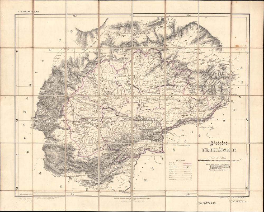
1906 Survey of India Folding Map of Peshawar and Environs
Peshawar-surveyofindia-1906$2,000.00


Title
District Peshawar.
1906 (dated) 24.5 x 30 in (62.23 x 76.2 cm) 1 : 253440
1906 (dated) 24.5 x 30 in (62.23 x 76.2 cm) 1 : 253440
Description
A scarce folding map of Peshawar and environs, originally published in 1884 by the Survey of India and here updated to 1906. It presents the region as it was solidified as the frontline of the British Raj and a buffer zone between India and Afghanistan.
A Closer Look
The Peshawar District, consisting of the namesake city and surrounding areas, is displayed with the Survey of India's characteristic thoroughness and attention to detail. Mountains (with elevation), waterways (including canals and seasonal waterways, indicated with dashed lines), roads (metalled and unmetalled), railways, administrative divisions, settlements, forts and cantonments, and other features are noted throughout. The map also records the borders and stations (seats) of tashils, a term used to the present for a unit of local administration in South Asia, roughly equivalent to a subdistrict.Frontier Stronghold
In the decades before this map's publication, Peshawar became a British stronghold on the northwestern frontier of India, due to its location in a valley near the strategically important Khyber Pass (here as Khaibar Pass, due west of Peshawar), a gateway to Afghanistan and beyond. This made the region the frontline in the 'Great Game' contest with the Russian Empire. The northwestern frontier had also been restive, with many local tribes effectively resisting British intrusion into their lands. Therefore, the British heavily fortified Peshawar and surrounding towns, linked them by rail, road, and telegraph with the rest of India, and devoted funds to the city to build new infrastructure, schools, and impressive public buildings. Grand structures, including the Cunningham Clock Tower, Victoria Hall (now the Peshawar Museum), Edwardes College, and Islamia College, were constructed in the early 20th century in a hybrid European, Hindu, Buddhist, and Mughal architectural style. The British also aimed to boost trade and development in the region, including an elaborate canal system off the Swat River seen here. However, these efforts tended to irritate the fiercely independent local tribes, leading to multiple uprisings that were only quelled with military expeditions followed by negotiated solutions.The Kyber Railway
The rail line seen here running from Peshawar through Kacha Garhi to Jamrud Fort was the first stage of the Khyber Railway or Khyber Pass Railway, opened the year before this map's publication. Over the next twenty years, a line was gradually extended over difficult terrain through Ali Masjid, Landi Kotal, and 34 tunnels to a station at Landi Khana (now Torkham) on the border Afghanistan. Though built for military and political purposes, by the time the line was completed, the Russian Empire had ceased to exist. Instead, it served as a passenger train until the early 1980s and intermittently as a heritage line.Publication History and Census
This map was originally prepared by the Survey of India, under the direction of George Charles Depree, in 1884. The map was updated twice before the current edition, in 1885 and 1889 (see OCLC 556996338 'all formats and editions'). Regardless of edition, the map is rare, only being noted in the OCLC among the holdings of the British Library and Oxford University.CartographerS
Survey of India (1767 - Present) is India's central engineering agency in charge of mapping and surveying the country. It was founded in 1767 by Major James Rennell, who took the post of first Surveyor General, with the mission to map and consolidate the territories of the British East India Company. The Survey undertook the Great Trigonometrical Survey between 1802 and 1852 in an attempt to accurately measure the Indian Subcontinent - considered one of the greatest feats of mapping of all time. It also sponsored clandestine surveys, at times disguised as Buddhist pilgrims, to infiltrate and map Tibet, then a closed country. With India's independence in 1947, the Survey was folded into the new Indian government, which it remains part of to this day. More by this mapmaker...
George Charles Depree (c. 1832 - 1887), sometimes as De Pree or De Prée, was a British military officer and surveyor active over a long career in South Asia in the second half of the 19th century. The details of his early life and training are obscure, but in 1851 Depree joined the Bengal Artillery and was decorated for his service in the Second Anglo-Burmese War (1852 - 1853). Afterwards, he stayed in India, remaining as a member of the Indian Staff Corp and joining the Great Trigonometrical Survey and the Survey of India. He was assigned to the Ganjam district and then conducted topographical surveys of Chota Nagpur. Over the same period of time, he rose through the military ranks, eventually becoming a major. In 1884, he was made the Officiating Surveyor General of the Survey of India and Deputy Surveyor-General of Topographical Surveys, posts he held until 1887, the same year he died. His son Hugo (1870 - 1943) also became an artillery officer, serving in India and then the First World War, rising to the rank of Major General. Learn More...
Condition
Very good. Backed on linen. Light soiling in upper right quadrant.
References
OCLC 49270149, 556996338.