Digital Image: 1935 Survey of India Map of Peshawar, Pakistan
PeshawarGuide-surveyofindia-1935_d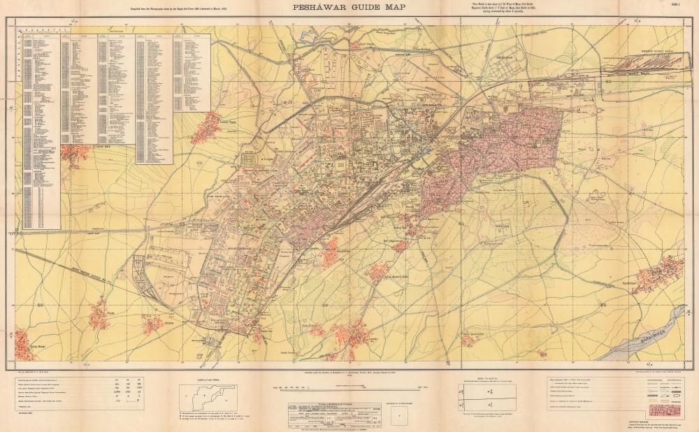

Title
Peshāwar Guide Map.
1935 (dated) 26.25 x 42.25 in (66.675 x 107.315 cm) 1 : 10560
1935 (dated) 26.25 x 42.25 in (66.675 x 107.315 cm) 1 : 10560
Description
FOR THE ORIGINAL ANTIQUE MAP, WITH HISTORICAL ANALYSIS, CLICK HERE.
Digital Map Information
Geographicus maintains an archive of high-resolution rare map scans. We scan our maps at 300 DPI or higher, with newer images being 600 DPI, (either TIFF or JPEG, depending on when the scan was done) which is most cases in suitable for enlargement and printing.
Delivery
Once you purchase our digital scan service, you will receive a download link via email - usually within seconds. Digital orders are delivered as ZIP files, an industry standard file compression protocol that any computer should be able to unpack. Some of our files are very large, and can take some time to download. Most files are saved into your computer's 'Downloads' folder. All delivery is electronic. No physical product is shipped.
Credit and Scope of Use
You can use your digial image any way you want! Our digital images are unrestricted by copyright and can be used, modified, and published freely. The textual description that accompanies the original antique map is not included in the sale of digital images and remains protected by copyright. That said, we put significant care and effort into scanning and editing these maps, and we’d appreciate a credit when possible. Should you wish to credit us, please use the following credit line:
Courtesy of Geographicus Rare Antique Maps (http://www.geographicus.com).
How Large Can I Print?
In general, at 300 DPI, you should at least be able to double the size of the actual image, more so with our 600 DPI images. So, if the original was 10 x 12 inches, you can print at 20 x 24 inches, without quality loss. If your display requirements can accommodate some loss in image quality, you can make it even larger. That being said, no quality of scan will allow you to blow up at 10 x 12 inch map to wall size without significant quality loss. For more information, it is best consult a printer or reprographics specialist.
Refunds
If the high resolution image you ordered is unavailable, we will fully refund your purchase. Otherwise, digital images scans are a service, not a tangible product, and cannot be returned or refunded once the download link is used.
Cartographer S
Survey of India (1767 - Present) is India's central engineering agency in charge of mapping and surveying the country. It was founded in 1767 by Major James Rennell, who took the post of first Surveyor General, with the mission to map and consolidate the territories of the British East India Company. The Survey undertook the Great Trigonometrical Survey between 1802 and 1852 in an attempt to accurately measure the Indian Subcontinent - considered one of the greatest feats of mapping of all time. It also sponsored clandestine surveys, at times disguised as Buddhist pilgrims, to infiltrate and map Tibet, then a closed country. With India's independence in 1947, the Survey was folded into the new Indian government, which it remains part of to this day. More by this mapmaker...
Harold John Couchman (July 29, 1882 - November 30, 1956) was a British surveyor and soldier who became Surveyor of India. Born in Haileybury, he attended school in Haileybury before entering the Royal Military Academy. Commissioned in the Royal Engineers in August 1900, Couchman was transferred to India in 1902. In 1906 he became part of the geodetic branch of the Survey of India. Initially assigned to assist with fieldwork, by the 1908-09 field season Couchman oversaw operations in southwest India. In 1910-11 he took part in the regional gravity surveys of Burma and then in 1912-14 in southern and central India. He was transferred to the headquarters office of the Survey of India in the spring of 1914. During World War I, he served in France and Belgium from September 1915 until November 1918. In 1919 he returned to the Survey of India and spent the rest of his career with the Survey, except for three years (1926 - 1929) when he served as deputy master, security printing. Over the course of these years, he served as director in Shillong, Simla, and Calcutta, and, in 1933, was appointed Surveyor General. He held that position until he retired in 1937. He rose to the rank of brigadier in 1933 and was knighted in 1937. He married Evelyn Beatrice in 1925 and they had no children. Learn More...
References
Lanzillo, A., 'Building Peshawar: Labor, Security, and Infrastructure at the Edge of Empire', Journal of Social History (Vol. 56, No. 3 Spring 2023) pp. 532-558. Accessed June 5, 2023.