This copy is copyright protected.
Copyright © 2025 Geographicus Rare Antique Maps
Digital Image: 1882 Smith Map of Philadelphia
Philadelphia-smith-1882_d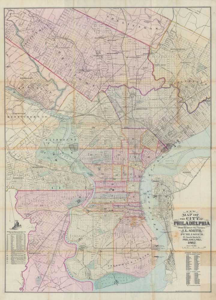


FOR THE ORIGINAL ANTIQUE MAP, WITH HISTORICAL ANALYSIS, CLICK HERE.
Digital Map Information
Geographicus maintains an archive of high-resolution rare map scans. We scan our maps at 300 DPI or higher, with newer images being 600 DPI, (either TIFF or JPEG, depending on when the scan was done) which is most cases in suitable for enlargement and printing.
Delivery
Once you purchase our digital scan service, you will receive a download link via email - usually within seconds. Digital orders are delivered as ZIP files, an industry standard file compression protocol that any computer should be able to unpack. Some of our files are very large, and can take some time to download. Most files are saved into your computer's 'Downloads' folder. All delivery is electronic. No physical product is shipped.
Credit and Scope of Use
You can use your digial image any way you want! Our digital images are unrestricted by copyright and can be used, modified, and published freely. The textual description that accompanies the original antique map is not included in the sale of digital images and remains protected by copyright. That said, we put significant care and effort into scanning and editing these maps, and we’d appreciate a credit when possible. Should you wish to credit us, please use the following credit line:
Courtesy of Geographicus Rare Antique Maps (http://www.geographicus.com).
How Large Can I Print?
In general, at 300 DPI, you should at least be able to double the size of the actual image, more so with our 600 DPI images. So, if the original was 10 x 12 inches, you can print at 20 x 24 inches, without quality loss. If your display requirements can accommodate some loss in image quality, you can make it even larger. That being said, no quality of scan will allow you to blow up at 10 x 12 inch map to wall size without significant quality loss. For more information, it is best consult a printer or reprographics specialist.
Refunds
If the high resolution image you ordered is unavailable, we will fully refund your purchase. Otherwise, digital images scans are a service, not a tangible product, and cannot be returned or refunded once the download link is used.
John L. Smith (March 19, 1846 - April 1, 1921) was a Philadelphia based stationer, map seller, publisher, and printer active in the late 19th and early 20th centuries. Smith served in the Civil war with Company K, 118th Pennsylvania, the 'Corn Exchange Regiment' from roughly 1862. He served in the Battle of North Anna and Bethesda Church, where he was wounded. He mustered out of service in 1865 and settled in Philadelphia. Smith subsequently worked with Rufus L. Barnes (1794 - 1868), whose business he acquired in 1868. His offices were at 27 South Sixth Street, Philadelphia. He retired from the map business in 1920. Smith rose to prominence and wealth and, when he died, left a large estate of $54,500 USD to charity. He had no children and lived as a bachelor at the Columbia Club, 1600 North Broad Street, until his death of a heart attack in 1921. He had a brother, William C. Smith, who survived him. More by this mapmaker...
Copyright © 2025 Geographicus Rare Antique Maps | Geographicus Rare Antique Maps
This copy is copyright protected.
Copyright © 2025 Geographicus Rare Antique Maps