Digital Image: 1861 Beers Wall Map of Philadelphia and Vicinity
PhiladelphiaVicinity-beers-1861_d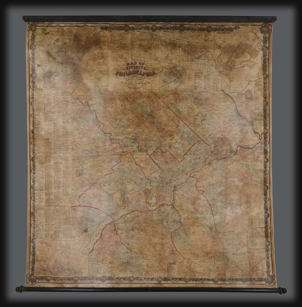


Title
Map of the Vicinity of Philadelphia.
1861 (dated) 67 x 64 in (170.18 x 162.56 cm) 1 : 63360
1861 (dated) 67 x 64 in (170.18 x 162.56 cm) 1 : 63360
Description
FOR THE ORIGINAL ANTIQUE MAP, WITH HISTORICAL ANALYSIS, CLICK HERE.
Digital Map Information
Geographicus maintains an archive of high-resolution rare map scans. We scan our maps at 300 DPI or higher, with newer images being 600 DPI, (either TIFF or JPEG, depending on when the scan was done) which is most cases in suitable for enlargement and printing.
Delivery
Once you purchase our digital scan service, you will receive a download link via email - usually within seconds. Digital orders are delivered as ZIP files, an industry standard file compression protocol that any computer should be able to unpack. Some of our files are very large, and can take some time to download. Most files are saved into your computer's 'Downloads' folder. All delivery is electronic. No physical product is shipped.
Credit and Scope of Use
You can use your digial image any way you want! Our digital images are unrestricted by copyright and can be used, modified, and published freely. The textual description that accompanies the original antique map is not included in the sale of digital images and remains protected by copyright. That said, we put significant care and effort into scanning and editing these maps, and we’d appreciate a credit when possible. Should you wish to credit us, please use the following credit line:
Courtesy of Geographicus Rare Antique Maps (http://www.geographicus.com).
How Large Can I Print?
In general, at 300 DPI, you should at least be able to double the size of the actual image, more so with our 600 DPI images. So, if the original was 10 x 12 inches, you can print at 20 x 24 inches, without quality loss. If your display requirements can accommodate some loss in image quality, you can make it even larger. That being said, no quality of scan will allow you to blow up at 10 x 12 inch map to wall size without significant quality loss. For more information, it is best consult a printer or reprographics specialist.
Refunds
If the high resolution image you ordered is unavailable, we will fully refund your purchase. Otherwise, digital images scans are a service, not a tangible product, and cannot be returned or refunded once the download link is used.
Cartographer S
Silas Norman Beers (September 3, 1837 - May 12, 1873) was a mapmaker in New York, the brother of Daniel Glover Beers (October 19, 1841 - February 12, 1913) and son of Charles Henry Beers (November 3, 1813 - March 5, 1892). He was marred to Sarah Nichols (1840 - 1933) in 1860. He lived most of his life in Connecticut as a farmer, but also worked as a Civil Engineer with his brother, Daniel Glover Beers, and uncle, Frederick William Beers (August 17, 1839 - September 8, 1933). More by this mapmaker...
Frederick William Beers (August 17, 1839 - September 8, 1933) was an American map publisher, cartographer, and surveyor. Beers was born in Maryland, the son of map publisher James Botsford Beers (October 16, 1811 - June 3, 1901), but lived much of his life in New York where he was the chief of the map division and Commissioner of Public Records in Brooklyn. He joined the family business in 1870 and along with his father, published the Farm Line Atlas of the County of Kings and the Atlas of Long Island. He is credited with personally mapping every county in New York State. Frederick worked with his family into the mapmaking trade, including his brother, Charles Henry Beers (November 3, 1813 - March 5, 1892), and nephews Silas Norman Beers (September 3, 1837 - May 12, 1873) and Daniel Glover Beers (October 19, 1841 - February 12, 1913). He retired from the publishing business in 1930, when he was more than 90 years old. He died on September 8, 1933 in Bridgeport, Connecticut. Learn More...
Daniel Glover Beers (October 19, 1841 - February 12, 1913) was an American farmer, surveyor, and mapmaker active in Connecticut. He is the brother of Silas Norman Beers (September 3, 1837 - May 12, 1873), son of Charles Henry Beers (November 3, 1813 - March 5, 1892), and nephew of Frederick William Beers (August 17, 1839 - September 8, 1933), all prominent mapmakers. D. G. Beer's name appears on the imprint of several Beers maps, including the large 1860 wall map of Philadelphia and vicinity, with Dunning Jackson Lake (1836 - 1915). In 1865 he partnered with one 'Pomeroy' of Rochester, New York to publish an Atlas of Delaware under the imprint of 'Pomeroy and Beers'. This business dissolved in 1880, after which he published independently as 'D. G. Beers and Co.' In the same year he patented a folding canvas canopy for covered wagons, a business that became extremely prosperous. Learn More...
Dunning Jackson Lake (1836 - December 27, 1915) was a prominent civil engineer and map publisher based in Philadelphia in the second half of the 19th century. He was most born in Fairfield County, Connecticut, where he would have been a close associate of the prominent Beers mapmaking family - with whom he would later collaborate extensively. He began his mapmaking career by publishing special issue maps of Pennsylvania, Ohio, and Indiana between 1860 and 1870. In 1873 he turned his attention to atlas publishing, issuing more than 40 county atlases covering parts of Michigan, Indiana, Pennsylvania, Maryland (10 atlases), and Ohio. In 1875 he partnered with Bruce N. Griffing and 'Stevenson' to form the firm of 'Lake, Griffing, and Stevenson'. This firm published extensively until 1879, when it was dissolved. From 1879 Lake published as D. J. Lake and Co., issuing works on Kentucky, Indiana, and Illinois. He later relocated to California where he died in 1915. Learn More...