
This item below is out of stock, but another example (left) is available. To view the available item, click "Details."
Details
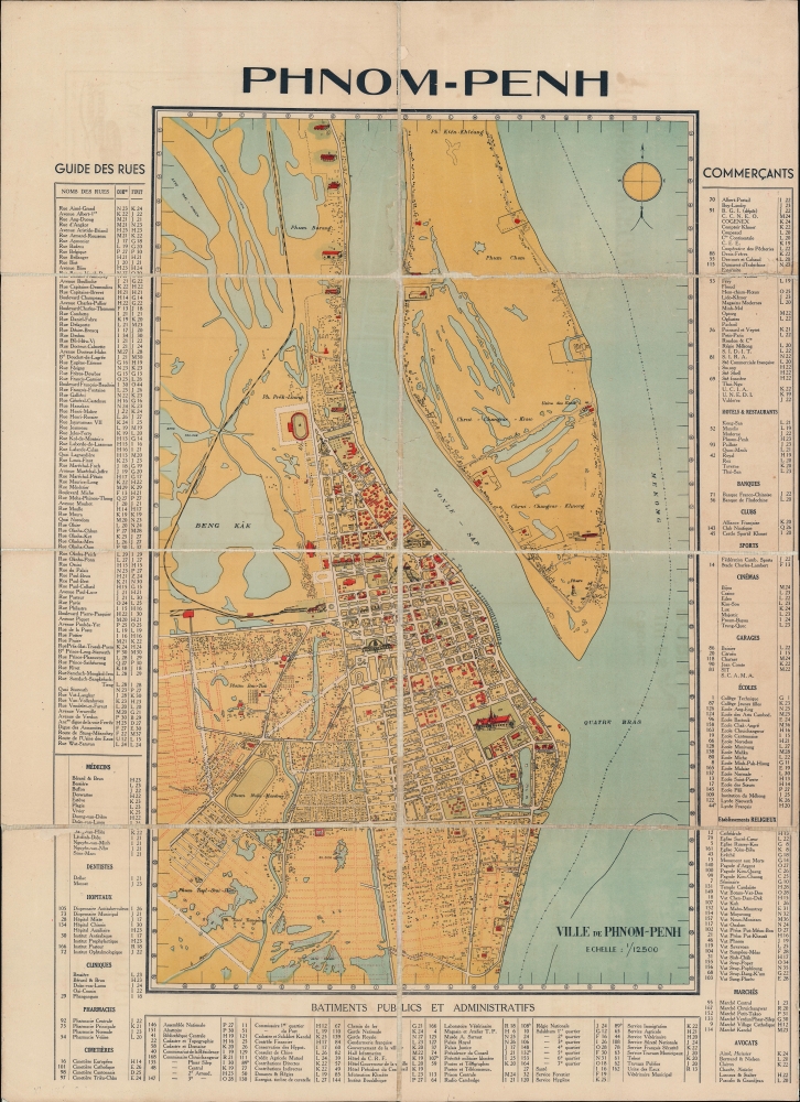
1935 Service Géographique de l'Indochine Wall Map of Phnom Penh, Cambodia
1935 (undated) $6,500.00
1935 French Pictorial Map of Phnom Penh, Cambodia
PhnomPenh-french-1935$600.00

Title
Phnom-Penh.
1935 (undated) 30.25 x 22 in (76.835 x 55.88 cm) 1 : 12000
1935 (undated) 30.25 x 22 in (76.835 x 55.88 cm) 1 : 12000
Description
A rare and striking c. 1935 map of Phnom Penh, capital of Cambodia. Covering the city from the Mekong to Beng Kâk and the Phnom Penh - Poipet Railway, the map represents a golden era of development for Phnom Penh, as major urban development projects, canals, and dredging efforts drained the swampy flood plain. A street and building index surrounds the piece and important structures are illustrated pictorially.
The 'Belle-Epoque' of Phnom Penh
Phnom-Penh was established as the capital of Cambodia in 1865 by King Norodom I (1860 - 1904). At the time, it was a waterlogged flood plain described by 19th century historian Penny Edwards asbest known for its vast tracts of mosquito-infested swampland, the stench of stagnant water and human waste, and frequent outbreaks of cholera.The French established a protectorate in Cambodia in the 1870s and began to remake the city as a grand colonial capital in the spirit of Saigon or Hanoi. Land reclamation efforts along the Tonle Sap River allowed the construction of a Grand Canal, located roughly between avenues 106 (Avenue Verneville) and 108 (Avenue Piquet). This was followed by a railroad in the 1920s, and the dredging and gridding of the region to the south of 108th Avenue (Avenue Piquet). The Grand Canal was filled and replaced with broad avenues and a park (Freedom Park) in the 1920s. The Phnom Penh Railway Station - shown here - was completed in 1932 at the western end of Freedom Park. Likewise, the impressive Psar Themy or New Market (no. 95) was built in a grandiose domed style using the then innovative material - reinforced concrete. The Japanese invaded Cambodia in 1941, stationing troops in Phnom-Penh, ending the French Era. At the end of WWII (1939 - 1945), King Norodom Sihanouk declared the independent Kingdom of Kampuchea, although it took another 8 years before the French colonial administrators recognized the claim.
Publication History and Census
The map is undated and no publisher is named. Judging from the development of Phnom Penh we can loosely date the map to about 1935 - during the pre-War French Colonial period. There are no other known examples.Condition
Good. The map is dissected and laid down on linen. The linen is old, but the dissecting pattern and some repairs, suggest it was laid down at a later date, likely to preserve its integrity. Overall toning. Edge wear. Wear on old folds.