
This item below is out of stock, but another example (left) is available. To view the available item, click "Details."
Details
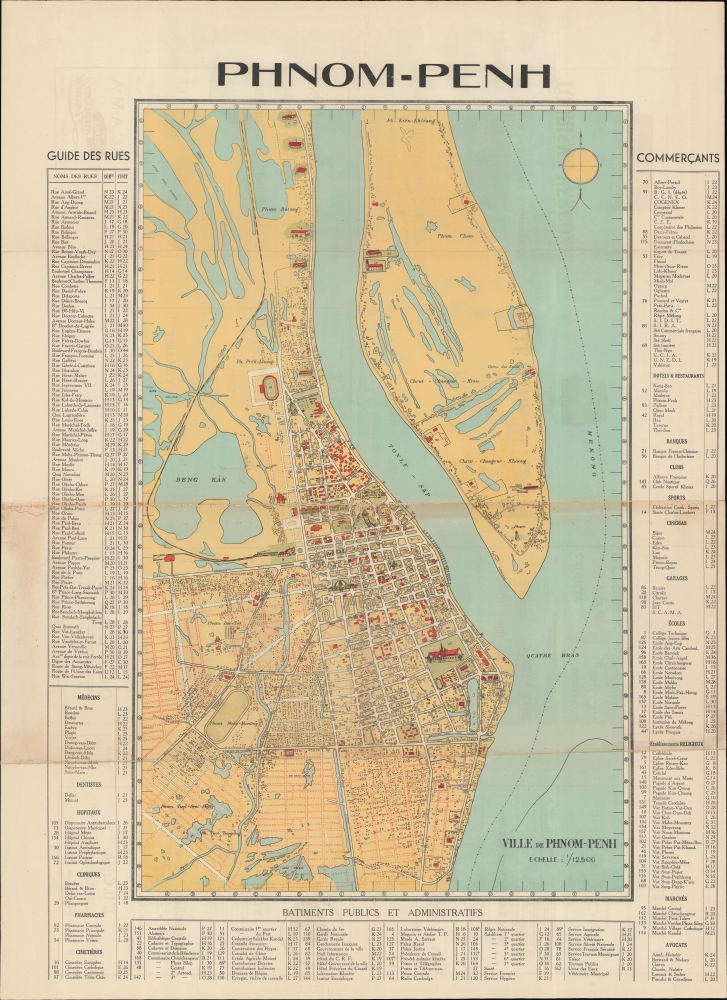
1935 Service Géographique de l'Indochine Wall Map of Phnom Penh, Cambodia
1935 (undated) $6,500.00
1935 French Pictorial Map of Phnom Penh, Cambodia
PhnomPenh-french-1935-2$600.00

Title
Phnom-Penh.
1935 (undated) 30.25 x 22 in (76.835 x 55.88 cm) 1 : 12000
1935 (undated) 30.25 x 22 in (76.835 x 55.88 cm) 1 : 12000
Description
A rare and striking c. 1935 chromolithograph map of Phnom-Penh, capital of Cambodia. The map covers the city from the Mekong to Beng Kâk and the Phnom Penh - Poipet Railway. The map represents a golden era of development for Phnom-Penh, as major urban development projects, canals, and dredging efforts drained the swampy flood plain. The map is surrounded by a street and building index, and important structures are illustrated pictorially.
The 'Belle Epoque' of Phnom-Penh
Phnom-Penh was established as the capital of Cambodia in 1865 by King Norodom I (1860 - 1904). At the time, it was a waterlogged flood plain described by the 19th century historian, Penny Edwards, asbest known for its vast tracts of mosquito-infested swampland, the stench of stagnant water and human waste, and frequent outbreaks of cholera.The French established a protectorate in Cambodia in the 1870s and began to remake the city as a grand colonial capital in the spirit of Saigon or Hanoi. Land reclamation efforts along the Tonle Sap River let do the construction of a Grand Canal, located roughly between avenues 106 (Avenue Verneville) and 108 (Avenue Piquet). This was followed by a railroad in the 1920s, and the dredging and gridding of the region to the south of 108th Avenue (Avenue Piquet). The Grand Canal was filled and replaced with broad avenues and a park (Freedom Park) in the 1920s. The Phnom-Penh Railway Station - shown here - was completed in 1932 at the western end of Freedom Park. Likewise, the impressive Psar Themy or New Market (no. 95) was built in a grandiose domed style using the then innovative material - reinforced concrete. The Japanese invaded Cambodia in 1941, stationing troops in Phnom-Penh, ending the French Era. At the end of WWII (1939 - 1945), King Norodom Sihanouk declared the independent Kingdom of Kampuchea, although it took another 8 years before the French colonial administrators recognized the claim.
Chromolithography
Chromolithography is a color lithographic technique developed in the mid-19th century. The process involved using multiple lithographic stones, one for each color, to yield a rich composite effect. Oftentimes, the process would start with a black basecoat upon which subsequent colors were layered. Some chromolithographs used 30 or more separate lithographic stones to achieve the desired product. Chromolithograph color could also be effectively blended for even more dramatic results. The process became extremely popular in the late 19th and early 20th centuries, when it emerged as the dominate method of color printing. The vivid color chromolithography produced made it exceptionally effective for advertising and propaganda imagery.Publication History and Census
The map is undated and no publisher is named. Judging from the development of Phnom-Penh we can loosely date the map to about 1935 - during the pre-War French Colonial period. There is but one other known examples, previously sold by Geographicus.Condition
Good. Some verso stabilization along horizontal centerfold, with slight loss. Closed tear from lower corner extending about 4 inches into the map repairs and stabilized on verso. Wear and toning on old folds.