1923 / 1947 Lobeck Physical Map of Europe
PhysiographicEurope-lobeck-1947$150.00

Title
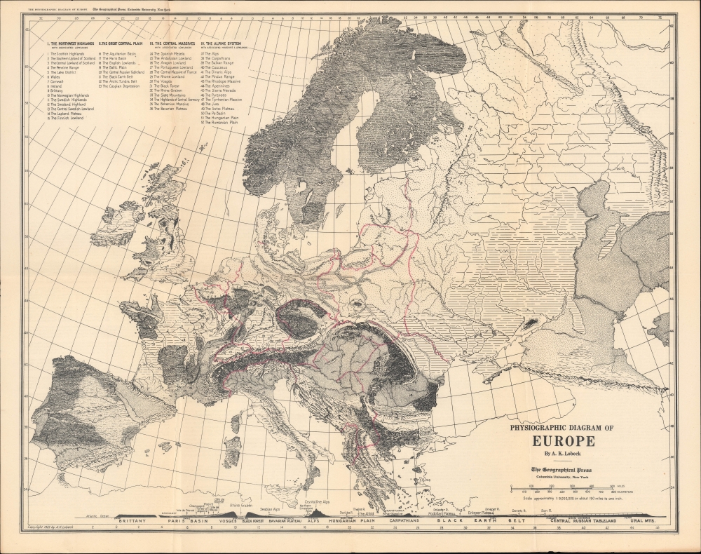
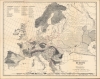
Physiographic Diagram of Europe.
1947 (dated) 18 x 22.5 in (45.72 x 57.15 cm) 1 : 9000000
1947 (dated) 18 x 22.5 in (45.72 x 57.15 cm) 1 : 9000000
Description
A physiographic map of Europe by Armin Lobeck, originally prepared in 1923 and reissued in 1947.
A Closer Look
Highlighting the variability of landscape in Europe, which Lobeck calls a 'checker-board,' this map focuses on the highlands, lowlands, plains, and other distinct geographical regions of Europe. The continent's mountainous and forested areas stand out particularly clearly. National borders are traced in red, though they are intentionally faint in comparison to the physical geography which is the focus of the map; in fact, the borders employed here do not reflect the realignments of the post-World War II period (with Poland and Yugoslavia, for instance, retaining their pre-1939 borders). Major cities are marked with circles, with the first letter of their name written ('L' for London, 'P' for Paris, and so on). Along the bottom is a profile of elevation of the continent running west to east, demonstrating the towering heights of the Alps, the highlands on either side of the Rhine River, and the markedly consistent tableland of central Russia.Publication History and Census
This map was originally prepared by Armin K. Lobeck in 1923 and published by the Geographical Press, part of Columbia University. It was reissued in multiple editions into the 1960s (in later years by C.S. Hammond, which acquired the Geographical Press). The present edition was published in 1947 and is noted among the holdings of the University of Illinois at Urbana Champaign, the University of Indiana, the University of Michigan, and the New York Public Library in the OCLC.Cartographer
Armin Kohl Lobeck (1886 - 1958) was an American geographer, cartographer, geologist, and artist based in New York City. Lobeck had a omnivorous approach to science and cartographer which reflected his educational background, studying botany and architecture in college and graduate school, both at Columbia University. After teaching at the Philadelphia College of Pharmacy for several years, Lobeck returned to Columbia to pursue a Ph.D., awarded in 1917. During World War I, he was assigned to the State Department and worked to prepare physiographic maps of areas that would be critical to negotiating a peace at the end of the conflict. After the war, he taught at the University of Wisconsin – Madison for ten years, then returned to teach at Columbia as a Professor of Geology. He produced 'Physiographic Diagrams' of the United States, Europe, and other parts of the world that were very well-received and reissued in multiple editions. During World War II, Lobeck worked for the General Staff of the U.S. Army (G-2), and the Army Map Service. More by this mapmaker...
Condition
Very good. One small instance of loss at fold junction professional repaired. Small number of pencil annotations near center. Text on verso. A second page contains text on both sides.
References
OCLC 67303330.