This item has been sold, but you can get on the Waitlist to be notified if another example becomes available, or purchase a digital scan.
1942 Ruth Pictorial Map of Northern Colorado and Estes Park
PictorialNorthernCO-ruth-1942$75.00

Title
Pictorial Map of the Rocky Mountain National Park Area and Northern Colorado.
1942 (dated) 21.75 x 16.5 in (55.245 x 41.91 cm)
1942 (dated) 21.75 x 16.5 in (55.245 x 41.91 cm)
Description
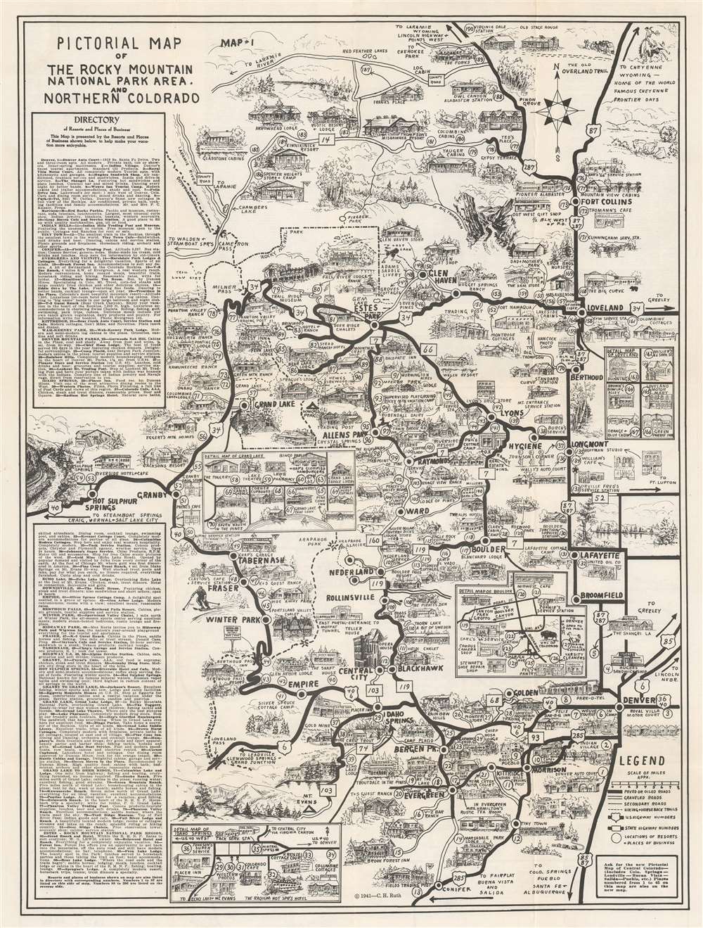
This is a 1942 C. H. Ruth pictorial map of northern Colorado and Rocky Mountain National Park. The map depicts the region from north of Fort Collins to Conifer and from Hot Sulphur Springs and Granby to Denver. Thick black lines mark U.S. and state highways, and bold black lettering labels cities and towns. Rocky Mountain National Park appears in the upper left and is delineated by a dotted and dashed line. Lodges, motels, service stations, stores, cabins, and myriad other businesses are illustrated in profile. 190 locations are numerically identified and indexed along the left side and on the verso. Inset maps detail business districts in Loveland, Grand Lake, Boulder, and Idaho Springs.
Verso Content
A detailed index occupies the top half of the verso and two smaller maps occupy the bottom half. Map 2 details the vicinity of Estes Park, the largest community close to Rocky Mountain National Park. Cabins, cottages, lodges, and other businesses adorn this map in the same style as the large map on the front. The third map, along the bottom of the sheet, details Estes Park itself and highlights hotels, cottages, and cabins, along with the local bookshop, barber shop, and high school auditorium. For a modern audience, the most interesting location here is likely The Stanley Hotel. The Stanley Hotel is where Steven King was inspired to write his classic novel The Shining and served as the location for the 1997 TV miniseries version of The Shining.Publication History and Census
This map was created by C. H. Ruth and published in 1942. An example is cataloged in OCLC and is part of the institutional collection at the University of Colorado Boulder. We are aware of one other example in private hands.Cartographer
C.H. Ruth (19xx - 19xx) was a cartographer and mapmaker active in the early to mid-20th century in the American West. Three pictorial maps of northern Colorado are known to have been created by Ruth and issued in 1939, 1940, and 1941 and focus on the region around Rocky Mountain National Park and the town of Estes Park. We have also found a source that credits a 'C.H. Ruth' for creating 'single sheet topographic maps' of national forests for the U.S. Forest Service. However, that source states that Ruth 'could not be found in Forest Service directories or in Polk's city directories of Missoula, Montana or Washington, D.C.' That source also speculates that since most of the maps created by C.H.Ruth were of forests in Idaho, that Ruth may have been based in Idaho. More by this mapmaker...
Condition
Very good. Exhibits light wear along original fold lines. Closed margin tears not effecting printed area professionally repaired on verso. Small maps and text printed on verso.
References
OCLC 1050365429.