Digital Image: 1888 Roethe / Elliott Bird's Eye View of 'Hangtown' Placerville, California
PlacervilleCAView-roethe-1888_d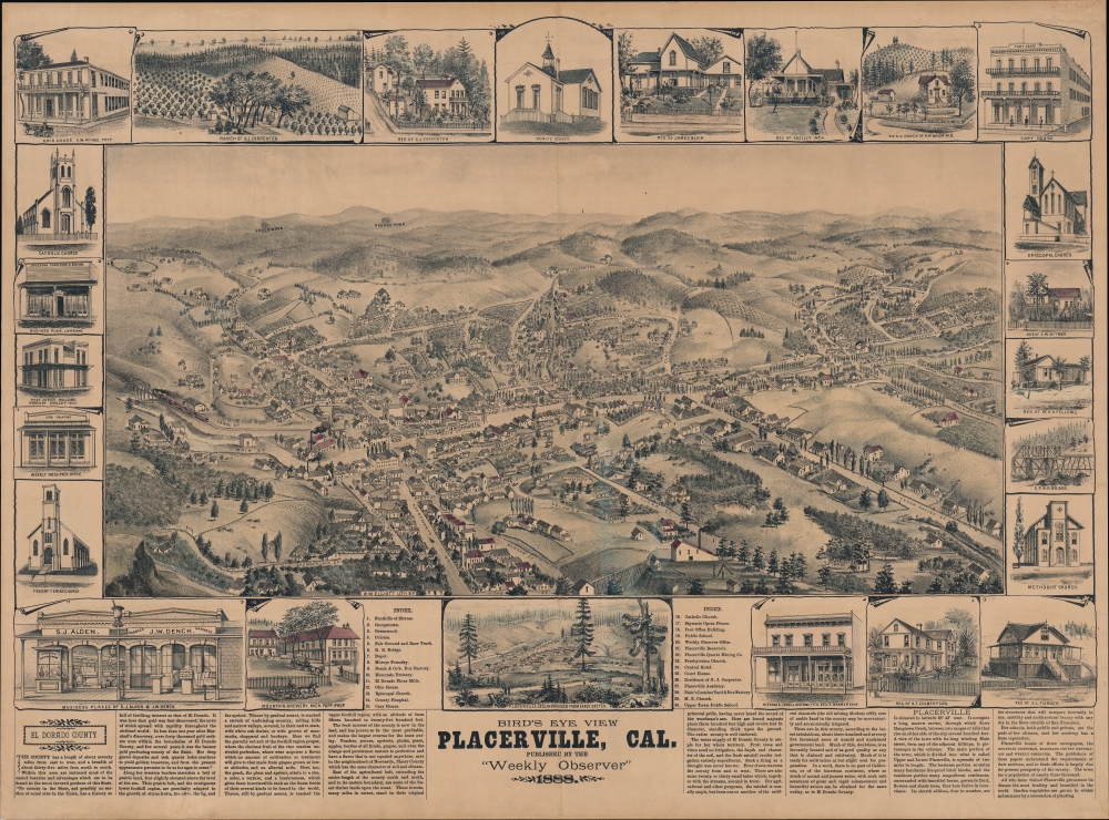

Title
Bird's Eye View Placerville, Cal.
1888 (dated) 20.75 x 28.5 in (52.705 x 72.39 cm)
1888 (dated) 20.75 x 28.5 in (52.705 x 72.39 cm)
Description
FOR THE ORIGINAL ANTIQUE MAP, WITH HISTORICAL ANALYSIS, CLICK HERE.
Digital Map Information
Geographicus maintains an archive of high-resolution rare map scans. We scan our maps at 300 DPI or higher, with newer images being 600 DPI, (either TIFF or JPEG, depending on when the scan was done) which is most cases in suitable for enlargement and printing.
Delivery
Once you purchase our digital scan service, you will receive a download link via email - usually within seconds. Digital orders are delivered as ZIP files, an industry standard file compression protocol that any computer should be able to unpack. Some of our files are very large, and can take some time to download. Most files are saved into your computer's 'Downloads' folder. All delivery is electronic. No physical product is shipped.
Credit and Scope of Use
You can use your digial image any way you want! Our digital images are unrestricted by copyright and can be used, modified, and published freely. The textual description that accompanies the original antique map is not included in the sale of digital images and remains protected by copyright. That said, we put significant care and effort into scanning and editing these maps, and we’d appreciate a credit when possible. Should you wish to credit us, please use the following credit line:
Courtesy of Geographicus Rare Antique Maps (http://www.geographicus.com).
How Large Can I Print?
In general, at 300 DPI, you should at least be able to double the size of the actual image, more so with our 600 DPI images. So, if the original was 10 x 12 inches, you can print at 20 x 24 inches, without quality loss. If your display requirements can accommodate some loss in image quality, you can make it even larger. That being said, no quality of scan will allow you to blow up at 10 x 12 inch map to wall size without significant quality loss. For more information, it is best consult a printer or reprographics specialist.
Refunds
If the high resolution image you ordered is unavailable, we will fully refund your purchase. Otherwise, digital images scans are a service, not a tangible product, and cannot be returned or refunded once the download link is used.
Cartographer S
Louis Henry Roethe (1860 - 1928) was an artist of Californian landscapes, scenes, and cities. Born in Shasta to parents who migrated during the Gold Rush, Roethe showed artistic skill at a young age and by 14 had entered the new San Francisco School of Design (now the San Francisco Art Institute). He studied under Virgil Macey Williams and Raymond Dabb Yelland (known for their California landscapes), as well as Oscar Kunath, known for portraiture. From 1880 - 1885, Roethe then spent five years in Bavaria, Germany honing his craft before returning to San Francisco and establishing a studio. More by this mapmaker...
Wallace William Elliott (fl. c. 1879 - 1891) was a short-lived but important lithographic artist, printer, and publisher based in the San Francisco Bay Area. The firm's (often but not always W.W. Elliott and Co.) output consists almost entirely of bird's-eye views of California cities (listed in Reps), along with histories of the young state's counties. Some other works also dealt with Arizona, Idaho, and the Pacific Northwest. Very little is known about Elliott (aside form being born in New York in 1842 and residing in Alameda County in his most active years) or his firm, which appears to have had operations in both San Francisco and Oakland. Learn More...
References
OCLC 5483065 (co-mingles originals and reproductions). Reps (1984), 243.