1715 Renard Map of the World on a Polar Projection
Planisphere-renard-1715$950.00

Title
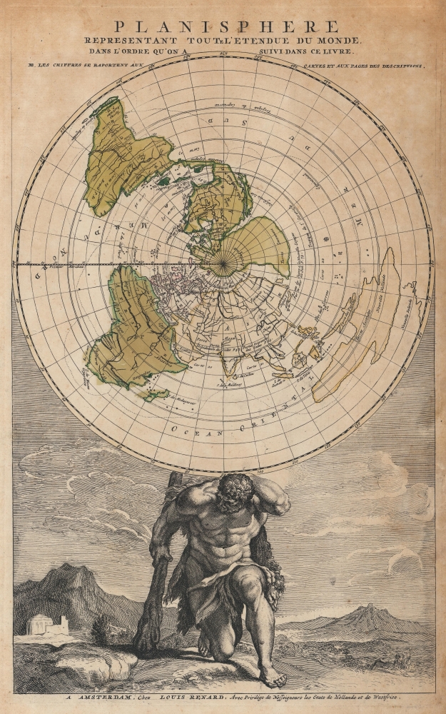
Planisphere representant toute l'etendue du monde dans l'ordre qu'on suivi dans ce livre.
1715 (undated) 17.25 x 10.5 in (43.815 x 26.67 cm) 1 : 140000000
1715 (undated) 17.25 x 10.5 in (43.815 x 26.67 cm) 1 : 140000000
Description
This is the 1715 Louis Renard map of the world on a polar projection. The map utilizes Jean-Dominique Cassini's ground-breaking work from the Paris Observatory and served at the frontispiece for Renard's Atlas de la navigation et du commerce qui se fait dans toutes les parties due monde. The frontis' interesting iconography substitutes Hercules for Atlas in supporting the world - the message being clear: 'out with the old, in with the new.'
A Closer Look - Intriguing Geography
The map illustrates the world on a North Polar Projection. The Northwest Passage here runs between North America and the speculative Arctic continent, labeled 'unknown lands' (terres inconnues). An elongated Island of California (Californie Isle) also draws attention. A highly distorted Australia, partially due to the projection, is mapped too far east and appears to wrap around New Zealand. Detailed river systems appear worldwide, with the Amazon, Niger, Congo, Nile, Rio de la Plata, and the Mississippi recognizable. Hercules, with his iconic lion skin and club, holds the world on his shoulders, having taken over for the penalized titan Atlas as part of his 11th Labor.Cassini's Map
The French Academy of Sciences was hard at work making scientific observations throughout the 1670s and 1680s. These observations came from over 40 stations worldwide and used new techniques for accurately determining longitude. Jean-Dominique Cassini (Giovanni Domenico Cassini), then the director of the Paris Observatory, translated this new information onto a map of the world measuring 8 meters across drawn on the observatory floor and composed from the 1670s through c. 1690. Luminaries from across Europe came to marvel at Cassini's work, and in 1696, Cassini's son Jacques and J. B. Nolin combined efforts to publish a reduced version on paper. This Cassini-Nolin map provided Renard with the basis for the present map.Publication History and Census
This map was created and published by Louis Renard in 1715. We note about a dozen examples cataloged worldwide in OCLC. A second edition was published c. 1790 by Jan Elwe and can be distinguished from the present first edition by the lack of Renard's imprint below the bottom border.Cartographer
Louis Renard (1678 - 1746) was a Huguenot engraver and bookseller. Renard was born in France in 1678 and moved to the Netherlands in 1703. He acquired many of Frederick de Wit's map plates, which he consolidated with minor updates and revisions into the 1715, Atlas de la Navigation et du Commerce. From about 1706 Renard represented the interest of Guillaume De L'Isle in Holland, a relationship that ended on a sour note in 1718. Renard later sold the plates for the Atlas de la Navigation et du Commerce to R. and J. Ottens, who republished it under their own imprint in 1745. More by this mapmaker...
Source
Renard, L., Atlas de la navigation et du commerce qui se fait dans toutes les parties due monde, (Amsterdam: Renard) 1715.
Condition
Very good. Closed margin tears professionally repaired on verso.
References
OCLC 224018134. Shirley #579.