This item has been sold, but you can get on the Waitlist to be notified if another example becomes available, or purchase a digital scan.
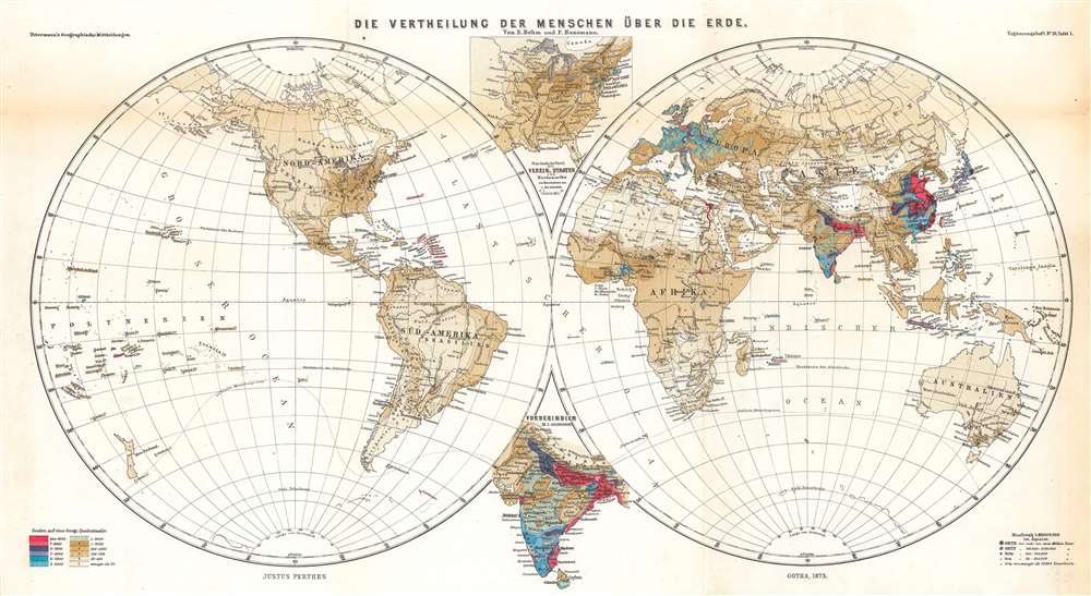
1873 Behm / Hanemann Hemisphere Map of Global Population Distribution
PopDistribution-petermann-1873
Title
1873 (undated) 11.75 x 21.25 in (29.845 x 53.975 cm) 1 : 80000000
Description
A Closer Look
The most immediate conclusion is the very high population density of the Indian Subcontinent, eastern China, the Nile Basin, and, to a lesser extent, Japan, Java, Western Europe, and portions of Southeast Asia, North America, and western and northern Africa. Outside of these populous lands, much of the world consists of wide-open spaces with relatively few inhabitants. It is worth noting that global population is estimated to have risen from some 1.2 billion in 1850 to 1.6 billion or more by 1900.Two inset maps are included, highlighting the eastern portion of North America and the Indian Subcontinent. The names of islands are underlined in a color corresponding to the shading used elsewhere. Aside from demonstrating population, the map also denotes major rivers, mountains, regions, and cities. Antarctica is hinted at towards the bottom of both hemisphere projections.
Publication History and Census
This map was prepared by Ernst Behm and Fr. Hanemann and was printed by Justus Perthes. It appeared in 1873 as Plate I in Supplemental Booklet (Ergänzungsheft) No. 35 to Petermann's geographische Mittheilungen, titled 'Die Bevölkerung der Erde…' This booklet was one of the first in what would become a regular series of supplements to Petermann's journal under the title Die Bevölkerung der Erde. It is independently cataloged among the holdings of six institutions in the OCLC, while Petermann's geographische Mittheilungen is more widely dispersed.CartographerS
August Heinrich Petermann (1822 - 1878) was a German cartographer. Petermann attended the 'Geographische Kuntschule' (Geographica School of Art), which was started by Heinrich Berghaus with the support of Alexander von Humboldt, in Potsdam beginning in 1839. Students at the school were obliged to work on many of the school's contracts, including maps for several different atlases. Following his time in Potsdam, Petermann relocated to Edinburgh and London from 1845 to 1854, where he gained insight into the commercial aspects of the cartography business. In 1854, Petermann returned to Gotha, Germany and began working with the Perthes brothers publishers. While working with the Perthes brothers, Petermann founded the journal Petermanns Geographische Mitteilungen, published from 1855 until 2014, long one of the most prominent German-language geography journals. More by this mapmaker...
Johan Georg Justus Perthes (September 11, 1749 - May 2, 1816) was one of the most important German cartographic engravers of the 19th century. He was born in the Thuringian town of Rudolstadt, the son of a court physician. In 1778, he began working as a bookseller in Gotha. Perthes began his publishing empire shortly thereafter with the 1784 issue of the famed survey of European nobility known as the Almanac de Gotha. In the next year, 1785, he founded the cartographic firm of Justus Perthes Geographische Anstalt Gotha. His son Wilhelm Perthes (1793 - 1853) joined the firm in 1814. Wilhelm had prior publishing experience at the firm of Justus Perthes' nephew, Friedrich Christoph Perthes, who ran a publishing house in Hamburg. After Justus Perthes died in 1816, Wilhelm took charge and laid the groundwork for the firm to become a cartographic publishing titan. From 1817 to 1890. the Perthes firm issued thousands of maps and more than 20 different atlases. Along with the visionary editors Hermann Berghaus (1797 - 1884), Adolph Stieler (1775 - 1836), and Karl Spruner (1803 - 1892), the Perthes firm pioneered the Hand Atlas. When Wilhelm retired, management of the firm passed to his son, Bernhardt Wilhelm Perthes (1821 – 1857). Bernhardt brought on the cartographic geniuses August Heinrich Peterman (1822 - 1878) and Bruno Hassenstein (1839 - 1902). The firm was subsequently passed to a fourth generation in the form of Berhanrd Perthes (1858 – 1919), Bernhard Wilhelm's son. The firm continued in the family until 1953 when, being in East Germany, it was nationalized and run as a state-owned enterprise as VEB Hermann Haack Geographisch-Kartographische Anstalt Gotha. The Justus family, led by Joachim Justus Perthes and his son Wolf-Jürgen Perthes, relocated to Darmstadt where they founded the Justus Perthes Geographische Verlagsanstalt Darmstadt. Learn More...
Ernst Behm (January 4, 1830 – March 15, 1884) was a German geographer and statistician born in Gotha, a city with a deep connection to the history of geography. After completing studies in medicine, Behm became fascinated with geography while preparing for a foreign medical assignment and fell in with Bernhard Perthes, of the Justus Perthes publishing dynasty, which also published Petermanns Geographischen Mitteilungen. Joining the staff of Petermann's journal in 1856, Behm would spend the rest of his life associated with the publication, authoring most of the unsigned essays in the journal over his tenure there. Following Petermann's death in 1878, he became editor of the journal until his own death six years later. He also founded Geographische Jahrbuch in 1866, edited the Gothaisches Hofkalender from 1876, and, with Hermann Wagner, established Die Bevölkerung der Erde as a regular supplement to Petermann's journal. In 1872, Behm wrote an article postulating that the Lualaba was the headstream of the Congo River, which Henry Morton Stanley vehemently denied at the time, but which he himself later confirmed to be true in 1877. Though not as well known as some of his collaborators and contemporaries, it would be fair to call Behm one of the most important German geographers of the second half of the 19th century. Learn More...

