Digital Image: 1777 J. Leopold Imbert Revolutionary War Map of the English Colonies
PossessionsAngloises-imbert-1777_d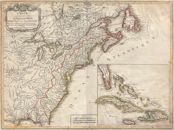

Title
Carte des Possessions Angloises Dans L'Amerique Septentrional Pour Servir d'Intelligence á la Guerre presente Traduite de L'Anglois Par J. Leopold Imbert.
1777 (dated) 21.5 x 29 in (54.61 x 73.66 cm) 1 : 5100000
1777 (dated) 21.5 x 29 in (54.61 x 73.66 cm) 1 : 5100000
Description
FOR THE ORIGINAL ANTIQUE MAP, WITH HISTORICAL ANALYSIS, CLICK HERE.
Digital Map Information
Geographicus maintains an archive of high-resolution rare map scans. We scan our maps at 300 DPI or higher, with newer images being 600 DPI, (either TIFF or JPEG, depending on when the scan was done) which is most cases in suitable for enlargement and printing.
Delivery
Once you purchase our digital scan service, you will receive a download link via email - usually within seconds. Digital orders are delivered as ZIP files, an industry standard file compression protocol that any computer should be able to unpack. Some of our files are very large, and can take some time to download. Most files are saved into your computer's 'Downloads' folder. All delivery is electronic. No physical product is shipped.
Credit and Scope of Use
You can use your digial image any way you want! Our digital images are unrestricted by copyright and can be used, modified, and published freely. The textual description that accompanies the original antique map is not included in the sale of digital images and remains protected by copyright. That said, we put significant care and effort into scanning and editing these maps, and we’d appreciate a credit when possible. Should you wish to credit us, please use the following credit line:
Courtesy of Geographicus Rare Antique Maps (http://www.geographicus.com).
How Large Can I Print?
In general, at 300 DPI, you should at least be able to double the size of the actual image, more so with our 600 DPI images. So, if the original was 10 x 12 inches, you can print at 20 x 24 inches, without quality loss. If your display requirements can accommodate some loss in image quality, you can make it even larger. That being said, no quality of scan will allow you to blow up at 10 x 12 inch map to wall size without significant quality loss. For more information, it is best consult a printer or reprographics specialist.
Refunds
If the high resolution image you ordered is unavailable, we will fully refund your purchase. Otherwise, digital images scans are a service, not a tangible product, and cannot be returned or refunded once the download link is used.
Cartographer S
J. Leopold Imbert (fl. c. 1777 - 1778) was a French mapmaker active in Paris during the 1770s. We have been able to isolate no substantial information on Imbert and he appears to have produced a single map, the important Carte Des Possessions Angloises Dans l'Amerique Septentrionale. More by this mapmaker...
Louis-Joseph Mondhare (1734 - August 21, 1796) was a French engraver and publisher of maps, prints and vues d'optique active in the second half of the 18th century. Mondhare was born in Bougy (Calvados) and moved to Paris on or before 1759. He began publishing around 1760 under the Chez Mondhare imprint. On June 7 of 1784, his son-in-law Pierre Jean (1754-1829) joined the business and they changed their imprint to Mondhare & Jean. The Mondhare firm maintained their office in Paris on Rue St. Jacques, at the Hôtel Saumar, a well-known location for print sellers near St. Severin. Later they relocated to 32 Rue Saint-Jean de Beauvais. The firm ceased operation around 1796. Mondhare died shortly afterward in 1799. His name variantly appears on some imprints as Mondar or Mondhard. Learn More...