This item has been sold, but you can get on the Waitlist to be notified if another example becomes available, or purchase a digital scan.
1786 Vaugondy Map of India and Ceylon
PresquIsleDesIndes2-vaugondy-1786$300.00

Title
Presqu'Isle des Indes Orientales, Comprenant l'Indostan ou Empire du Mogol, Differens Royaumes ou Etats, Les Vastes Possessions des Anglais, et les autres Etablissemens EuropEens, avec les Grandes Routes.
1786 (dated) 20 x 25.5 in (50.8 x 64.77 cm) 1 : 17280000
1786 (dated) 20 x 25.5 in (50.8 x 64.77 cm) 1 : 17280000
Description
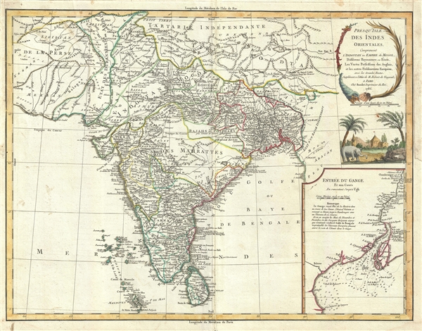
This is a scarce and beautiful 1786 map of India and Sri Lanka by Robert de Vaugondy. It covers the Indian subcontinent from Independent Tartary south to include Ceylon and the Maldives and from Persia east as far as Aracan in the east. It offers extraordinary detail throughout, with numerous notations on matters geographical, historical, and cultural. Shows roads, cities, mountain ranges, lakes and rivers with territories depicted by outline color. This map offers a smorgasbord of information for the historian interested political changes in India during the 18th century. Identifies Delhi (or Jehan Abad), Agra (or Ekbar Abad), Bombay, Goa, Calcutta, Pondicherry, and countless other major and minor cities. An inset in the lower right quadrant focuses on the mouths and the course of the River Ganga or Ganges from Hooghly, south part Calcutta into the Bay of Bengal.
Originally drawn in 1749, our map predates the definitive Alexander Dalrymple mapping of India in the 1770s and so is quite vague in a number of areas - especially those controlled the independent Maratha Confederacy southwest of Bihar. In this area there are several speculative rivers as well as large lake, labeled Chilea or Ganga. This is most likely an erroneous mapping of Chilka Lake (Chilika Lake). Chilka Lake is the second largest salt water lagoon in the world - but was clearly missed by early mapmakers working on the Orissa coast.
In Assam, Vaugondy maps the 'supposed' locations of the apocryphal Lake of Chiamay. Early cartographers speculated that such a lake must exist as the source of four important Southeast Asian river systems including the Irrawaddy, the Dharla, the Chao Phraya, and the Brahmaputra. This lake began to appear in maps of this region as early as the 16th century and persisted well into the late 18th century. Its origins are unknown but may originate in a lost 16th century geography prepared by the Portuguese scholar Jao de Barros. It was also heavily discussed in the journals of Sven Hedin, who believed it to be associated with Indian mythology that a sacred lake linked several holy river systems. There are even records that the King of Siam led an invasionary force to take control of the lake in the 16th century. Nonetheless, the theory of Lake Chimmay was ultimately disproved and it disappeared from maps entirely by the 1780s.
On the far east of the map, Vaugondy identifies the Kingdom of Arakan, which flourished in the 16th and 17th centuries. The city of Mrauk-U, marked here as Aracan, was once described by Portuguese merchants as one of the most beautiful locations on earth, is today a spectacular but derelict ruin.
An elaborate title cartouche depicting an elephant and a village appears in the top right quadrant of the map. This map was drawn by Robert de Vaugondy and published in the 1757 issue of his Atlas Universal. All in all a spectacular map with much to offer and a welcome addition to any serious collection focusing on the subcontinent.
Cartographer
Robert de Vaugondy (fl. c. 1716 - 1786) was French may publishing from run by brothers Gilles (1688 - 1766) and Didier (c. 1723 - 1786) Robert de Vaugondy. They were map publishers, engravers, and cartographers active in Paris during the mid-18th century. The father and son team were the inheritors to the important Nicolas Sanson (1600 - 1667) cartographic firm whose stock supplied much of their initial material. Graduating from Sanson's maps, Gilles, and more particularly Didier, began to produce their own substantial corpus. The Vaugondys were well-respected for the detail and accuracy of their maps, for which they capitalized on the resources of 18th-century Paris to compile the most accurate and fantasy-free maps possible. The Vaugondys compiled each map based on their own geographic knowledge, scholarly research, journals of contemporary explorers and missionaries, and direct astronomical observation. Moreover, unlike many cartographers of this period, they took pains to reference their sources. Nevertheless, even in 18th-century Paris, geographical knowledge was limited - especially regarding those unexplored portions of the world, including the poles, the Pacific Northwest of America, and the interiors of Africa, Australia, and South America. In these areas, the Vaugondys, like their rivals De L'Isle and Buache, must be considered speculative or positivist geographers. Speculative geography was a genre of mapmaking that evolved in Europe, particularly Paris, in the middle to late 18th century. Cartographers in this genre would fill in unknown lands with theories based on their knowledge of cartography, personal geographical theories, and often dubious primary source material gathered by explorers. This approach, which attempted to use the known to validate the unknown, naturally engendered rivalries. Vaugondy's feuds with other cartographers, most specifically Phillipe Buache, resulted in numerous conflicting papers presented before the Academie des Sciences, of which both were members. The era of speculative cartography effectively ended with the late 18th-century explorations of Captain Cook, Jean Francois de Galaup de La Perouse, and George Vancouver. After Didier died, his maps were acquired by Jean-Baptiste Fortin, who in 1787 sold them to Charles-François Delamarche (1740 - 1817). While Delamarche prospered from the Vaugondy maps, he defrauded Vaugondy's window Marie Louise Rosalie Dangy of her rightful inheritance and may even have killed her. More by this mapmaker...
Source
Robert de Vaugondy, G., Atlas Universel, (Paris: Antoine Boudet) 1757.
The Atlas Universel was the crowning glory of the Robert de Vaugondy firm's atlas production. The atlas was revolutionary on many levels and exemplified the Vaugondy credo commode, complet, univorme, et suive (convenient, complete, uniform, and easy to use). The atlas thus consisted of a wide corpus of maps, both modern and historical, was of moderate height and width, and featured maps of uniform style and structure. They partnered with Antoine Boudet, a shrewd businessman and publisher with whom they had worked previously, to produce the 1752 first edition. To minimize his fiscal risk, Boudet sold the atlas first by subscription using a large prospectus, receiving in the process over 1100 pre-orders. The first edition appeared in 1752 and contained beautifully produced maps with elaborate freshly designed allegorical cartouche work, generally by Pierre-Edme Babel, Pierre Philippe Choffard, and Charles Nicholas Cochin. Most of the maps were engraved by the Delahaye firm, the payment for whose services ultimately led to legal disputes. Despite proving a popular work of astounding quality, the Atlas Universal received harsh criticism from fellow cartographers, particularly Philipppe Buache. Ever at odds with the Vaugondys, Buache's critical perspective may have been influenced more by political maneuvering than academic affront. The atlas was issued in multiple editions between 1752 and 1788. Later editions, issued after 1786, were taken over by Charles Delamarche, who inherited the Robert de Vaugondy firm and assumed Boudet's publication rights.
Condition
Very good. Light spotting at margins. Original platemark visible. Minor centerfold reinforcement at margins.
References
Pedley, Mary Sponberg Belle et Utile: The Work of the Robert de Vaugondy Family of Mapmakers, 399.