1867 Hickenlooper Plat Map of Prospect Hill, Mount Auburn, Cincinnati, Ohio
ProspectHillSub-phillipshickenlooper-1867$950.00

Title
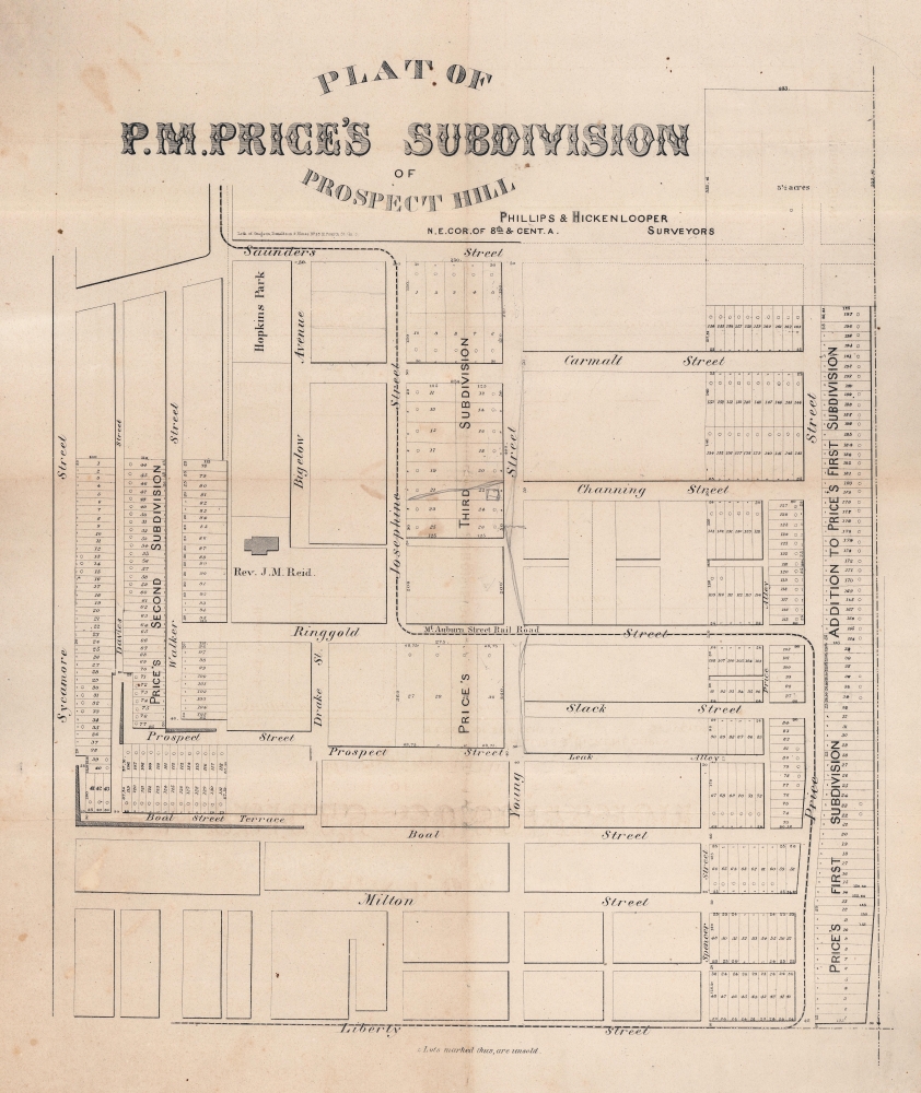
Plat of P. M. Price's Subdivision of Prospect Hill.
1867 (undated) 18 x 22 in (45.72 x 55.88 cm) 1 : 1300
1867 (undated) 18 x 22 in (45.72 x 55.88 cm) 1 : 1300
Description
This is a c. 1867 Phillips and Hickenlooper plat map of the Prospect Hill district in Cincinnati, Ohio. Today Prospect Hill is part of the Mount Auburn neighborhood and is just outside downtown Cincinnati.
A Closer Look
Depicting from Sycamore Street to Price Street and from Liberty Street to Saunders Street, lots are delineated, although not all have been surveyed. Small circles mark unsold lots. The Mt. Auburn Street Rail Road runs along Saunders, Josephine, Ringgold, and Price Streets. The slow expansion of 'Price's Subdivision' is evident, with the first, second, and third subdivisions labeled, although not clearly delineated.Prospect Hill Historic District and Mount Auburn Historic District
The Prospect Hill district and the Mount Auburn neighborhood in general were arguably Cincinnati's first suburb. The neighborhood spring to life as a way for the city's wealthiest to escape the crowded, dirty conditions of the lower city. Mount Auburn was first platted in 1837 and was annexed by Cincinnati in 1849. Among the neighborhood's noted residents is Former President and Chief Justice William Howard Taft.Plat Maps
The plat or land ownership map grew out of the Public Land Survey System (PLSS), a system that was implemented in to survey the Northwest Ordinance, which was acquired in 1787. The PLSS allowed for the systematic surveying and mapping of any territory gained by the United States by surveying the territory in question into an orderly grid. These first plats illustrated distances between section corners and sometimes included topographical data or other information and were drawn to scale. Plat maps began to evolve later in the 19th century, with both the Sanborn Map Company and the G. M. Hopkins Company taking the plat map and adding to it. The Sanborn Map Company, founded by D.A. Sanborn in 1866, created detailed fire insurance maps. A concept begun in London in the late 18th century, the practice was adopted by the American insurance industry in the mid-19th century. Sanborn was among the first to publish fire insurance maps in the United States, after first being contracted by the Aetna Insurance Company to prepare fire insurance maps for areas of Tennessee. He was concurrently working on similar maps of Boston, which he published as Insurance Map of Boston in 1867. These maps helped insurance underwriters determine fire risk, tracking such factors as ceiling height, number of stories, building materials, and proximity to other buildings and fire departments. The G.M. Hopkins Company took the discipline in a different direction. They began producing plat maps that traced property owners, landmarks such as churches and cemeteries, roads, and bodies of water. Hopkins maps are incredibly detailed, noting the dimensions of lots, the width of streets, and names of property owners. This type of map would soon be known as cadastral maps with well-known cartographers such as F.W. Beers and John Bute Holmes making their reputations on the creation of detailed and accurate maps tracing the evolution of American cities. Plat maps are still used today to determine lots, easements, zoning compliance, and other land use questions.Publication History and Census
This map was created by R. C. Phillips and Andrew Hickenlooper and printed by Donaldson and Elms c. 1867. We note a single cataloged example which is part of the collection of the Cincinnati History Library at the Cincinnati Museum Center.CartographerS
Robert Christmas Phillips (December 25, 1811 - December 30, 1881) was an American civil engineer and surveyor. Born in Ohio, Phillips worked in Cincinnati for nearly fifty years, most of that time as an engineer. He served for a time as City Engineer. Over the course of his career, he surveyed numerous parts of the city and laid out lots. For a time, he operated an engineering and surveying firm with Andrew Hickenlooper called Phillips and Hickenlooper. By 1872 Phillips was serving as the Chief Engineer of Public Works in the District of Columbia. He married Mary S. Humber on August 2, 1843, with whom he had five children. More by this mapmaker...
Andrew Hickenlooper (August 10, 1837 - May 12, 1904) was an American civil engineer, surveyor, and Union Army veteran. Born in Hudson, Ohio Hickenlooper attended St. Xavier and Woodward High School before embarking on a surveying career. He began his professional training in 1853 as a rodman in the City Engineer's Office of Cincinnati under A. W. Gilbert, then the city engineer. After Gilbert's term in office ended two years later, Hickenlooper went into business with him and formed the firm Gilbert and Hickenlooper. This firm lasted for two years, until Gilbert won another term as city engineer, at which point Hickenlooper went into business for himself. He entered military service on August 31, 1861, as captain of 'Hickenlooper's Cincinnati Battery', which was mustered into the army as the Fifth Ohio Battery of Light Artillery at the St. Louis Arsenal, Missouri. Hickenlooper spent the next four years in the Union Army and fought in the Battle of Shiloh, the Siege of Vicksburg, the Battle of Atlanta, and Sherman's March to the Sea. He also fought in the Carolina campaign and was at both Columbia and Raleigh. He eventually rose to the rank of brevet brigadier general. He was mustered out on August 31, 1865. After the war Hickenlooper returned to Cincinnati where he partnered with R. C. Phillips in the engineering and surveying firm Phillips and Hickenlooper. He was appointed United States Marshal for the Southern District of Ohio on July 7, 1866, and served until January 1871, when he resigned to become City Civil Engineer of Cincinnati. He resigned that position on May 8, 1872 to become vice president of the Cincinnati Gas, Light, and Coke Company, and rose to president on May 8, 1877. He was elected Lieutenant Governor of Ohio on October 14, 1879, and served a two-year term. Hickenlooper married Marial Lloyd Smith on February 13, 1867, with whom he had six children. Learn More...
William Mills Donaldson (March 14, 1840 - October 22, 1931) was an American businessman and lithographer. Born in Cincinnati, Donaldson's father died when he was a few months old and his mother died when he was ten. He was a sickly child but sought an education, mostly at the encouragement of his grandfather. In the late 1850s, when his uncle (who was in charge of his estate) forbade him entering medical school because it was too expensive, Donaldson left school and found work at Middleton-Wallace and Company, a lithographer in Cincinnati. Middleton-Wallace closed in December 1860, but reopened in January 1861. Donaldson went into business for himself in 1863, opening a lithographic firm with his close friend and fellow lithographer Henry Elms, with Donaldson as the senior partner. Then, in 1864, Donaldson decided to begin printing chromolithographs, which caused the firm's success to grow exponentially. By 1868 they had been forced to relocate twice because of a need for bigger premises. Henry Elms died in 1872, leaving Donaldson to run the business on his own. Nonetheless the firm continued to grow and prosper. Donaldson used this success to further expand the business and began framing as well. Donaldson sold the Donaldson Lithographing Company to the Consolidated Lithographing Company in 1905. Learn More...
Condition
Good. Wear along original fold lines. Verso repairs to fold separations and at fold intersections. Small areas of infill at fold intersections. Slight loss along fold lines.
References
OCLC 27183788.