This item has been sold, but you can get on the Waitlist to be notified if another example becomes available, or purchase a digital scan.
1831 Stucchi Astronomical Chart of the Solar System and its Mechanics
ProspettoDimostrativo-stucchi-1831$400.00

Title
Prospetto Dimostrativo de pui interessanti fenomeni fisico-astronomici che risguardano il Globo terrestre.
1831 (dated) 21.25 x 29.5 in (53.975 x 74.93 cm)
1831 (dated) 21.25 x 29.5 in (53.975 x 74.93 cm)
Description
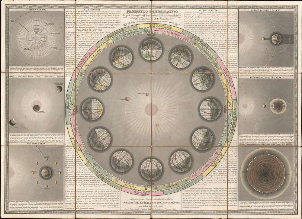
This is an 1891 Stanislao Stucchi chart of the Solar System and its mechanics. Seven charts printed on one sheet and short explanations accompany each chart.
- the central chart illustrates the Earth orbiting around the Sun and explains how this orbit causes seasonal changes. The Sun appears at the center, with Mercury and Venus both illustrated and labeled between it and the Earth. Two rings surround the central illustration and trace the months of the year and the signs of the zodiac. Equinox and solstices are noted.
- The chart on the top left depicts the Solar System as a whole and illustrates the orbits of Mercury, Venus, Earth, Mars, Jupiter, Saturn, and Uranus, as well as the moons of Earth, Jupiter, Saturn, and Uranus. The orbits of the four largest asteroids in the asteroid belt, Vesta, Juno, Pallas, and Ceres, are also illustrated. The length of each orbit (measured in Earth years) is provided.
- The second chart depicts the Earth's orbit around the Sun and labels the summer and winter solstices and the autumnal equinox.
- The third chart details the phases of the Moon relative to the Earth and the Sun. It also includes the Earth's orbit.
- The chart on the top right depicts the position of the Sun and the Moon during solar and lunar eclipses.
- The middle chart on the right explains how the Sun and Moon effect ocean tides relative to the rotation of the Earth and the Moon.
- The bottom chart on the right illustrates the Earth and its atmosphere in cross-section. Bands of shading illustrate the Earth's layers. Pichincha, a volcano in Columbia, and Mount Ophir, a volcano in Sumatra, are labeled. The Indian Ocean, Africa, the Gulf of Guinea, the Atlantic Ocean, South America, the Galapagos Islands, the Pacific Ocean, the Isle of Dundas (British Columbia), and the Maluku Islands.
Publication History and Census
This chart was created and published by Stanislao Stucchi in 1831. The individual charts were inspired by those published by Sigismond Visconti in 1815. This chart is not cataloged in OCLC and we have been unable to locate any other examples.Cartographer
Stanislao Stucchi (c. 1780 - 18xx) was a Milanese engraver and publisher active in Milan during the early 19th century. He published maps, views, and other printed images. More by this mapmaker...
Condition
Very good. Dissected and mounted on linen in twelve (12) panels. Linen exhibits wear along original fold lines. Verso repair to linen fold separation.

