This item has been sold, but you can get on the Waitlist to be notified if another example becomes available, or purchase a digital scan.
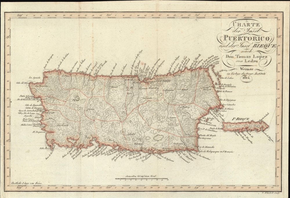
1814 Thomas Lopez Map of Puerto Rico / Porto Rico
PuertoRico-lopez-1814
Title
1814 (dated) 9.25 x 13.25 in (23.495 x 33.655 cm) 1 : 900000
Description
A Closer Look
Coverage embraces the island of Puerto Rico (Porto Rico) and adjacent Vieques (Bieque). Although dated 1814, the map details Puerto Rico during Ledru and Baudin's visit, 1797-98. It nonetheless relies, with Ledru's updates, on the cartography of Tomás López de Vargas Machuca, the premier Spanish cartographer of his generation, making it superior to most contemporaneous maps. Typical of most maps of Puerto Rico issued prior to the mid-19th century, inland detail is minimal, but coastal detail is rich. The cartographer attempts to illustrate the island's complex topography and the important trans-island road, extending from San Juan through Caguas and Aybonito (Aibonito), to the south Coast is evident.Publication History and Census
This map was issued to accompany the 1814 German edition of Andree Pierre Ledru's Voyage aux isles de Tenerif, La Trinite, St. Thomas, Ste. Croix, et Porto Rico…. It was expertly engraved by C. Ehnlich for the Geographisches Institut, Weimar. The work was first issued in 1810, but this map did not appear until the German edition of 1814. Scare on the market.CartographerS
Tomás López de Vargas Machuca (1730 - July 19, 1802) was a Spanish cartographer active in the later part of the 18th century. Vargas was born in Toledo and studied mathematics, grammar, and rhetoric at the Colegio Imperial in Madrid. In 1752, with the patronage of the Marquis de la Ensenada, he relocated to Paris to study. López attended the Mazarin College, where he received two courses in Mathematics and lessons in geography from the Abbé de la Caille, Joseph Jérome de Lalande, and Louis Gabriel. He also studied cartography direclty under the legendary French mapmaker Jean Baptiste Bourguignon d'Anville (1697 - 1782). Back in Madrid, he collaborated with the geographer Juan de la Cruz on two educational atlases, published in 1757 and 1758. Around 1770, King Carolos III, appointed him Geógrafo de los Dominios de Su Magestad and gave him charge over the newly created Gabinete de Geografía. In this position, he dedicated the remainder of his life to a detailed mapping of Spain, producing numerous important regional maps, many correcting common mistakes made by foreign geographers. He also ran a private map publishing business in Madrid, first on San Bernardo (1761 - 65), the on Las Carretas (opposite Gamete; 1765 - 1783), and infamy on Atocha (1783 - 1802). He was a member of the Real Academia de San Fernando, the Real Sociedad Bascongada de Amigos del País and the Academia de Bellas Letras de Sevilla. López was succeeded by his two sons, also cartographers, who published several atlases based upon his work. The appraisal of his estate at the time was 489,800 reales (about 1,000,000 USD today), a figure indicative of his success. More by this mapmaker...
André-Pierre Ledru (January 22, 1761 - 1825) was a French botanist best known for participating in Nicolas Baudin's 1797-98 expedition to the Canary Islands and West Indies. Ledru was born in Chantenay-Villedieu, La Sarthe, and initially trained to join the priesthood, becoming a vicar. When the French Revolution (1789 - 1799) broke out, and religion was outlawed, he changed paths, focusing on botany. He returned to his home of La Sarthe. When Sarthe was devastated by the French Civil War, he fled to Paris, attempting to avoid anti-clerical revolutionaries. In 1796, when the famous explorer Nicolas Baudin (1754 - 1803) began organizing a new voyage on behalf of the Paris Museum of Natural History, this time to the West Indies, Ledru was appointed official botanist. The Baudin expedition focused on Puerto Rico, where Ledru collected plant and other samples. When the voyage returned to France, he turned to teaching law and physics in La Sarthe. He later took part in the Napoleonic Wars (1803 - 1815), where he was wounded at the 1906 Battle of Jena. He published an account of his travels, Voyage aux isles de Tenerif, La Trinite, St. Thomas, Ste. Croix, et Porto Rico…, in 1810. In 1816, he again moved to Paris, before retiring to Le Mans, where he focused on scientific works until he died in 1825. Today, the Le Mans city museum houses his personal herbarium. Learn More...
Geographisches Institut, Weimar (fl. 1804 - c. 1903) was a German map and globe publishing house and geographical research institute based in Weimar. The organization primarily focused on republishing and improving upon the works of earlier cartographers, including Kitchin, Jefferys, Carey, and others. In general, its publications are known for their fine engraving, attention to detail, historical accuracy, and overall high quality. The firm was founded in 1804 by Friedrich Justin Bertuch (???? - c. 1845) and, on his death, passed to his son Robert Froreip (???? - 1855), then to Louis Denicks of Luneberg, then in 1859 to Voigt & Günther, in 1883 to F. Arnd, from 1890 - 1893 to Julius Kettler, and in 1903 to Max Wedekind. During the institute's height in the early 19th century, most of its cartographic publication was overseen by Carl Ferdinand Weiland (1782 - 1847). The firm also employed the cartographers Franz Xaver von Zach, Adam Christian Gaspari, Heinrich Kiepert, Karl (or Carl) and Adolf Graef, Julius Kettler, Carl Riemer and Karl Christian Bruhns. Weimar was a logical place for a collective like the Geographisches Institut to arise; it was a cultural mecca in the German-speaking world in the late 18th and 19th centuries because of its liberal atmosphere and associations with figures like Schiller, Herder, and, above all, Goethe, who spent most of his adult life in the city. Learn More...
C. Ehnlich (fl. c. 1805 - 1820) was a German engraver active with the Geographisches Institut, Weimar, in the early 19th century. Learn More...

