This item has been sold, but you can get on the Waitlist to be notified if another example becomes available, or purchase a digital scan.
1934 RCA Radiotron Radio Map of the United States
RadioTours-rca-1934-2$150.00


Title
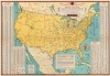
RCA Radio Tours - America's Latest Game.
1934 (undated) 18 x 25.75 in (45.72 x 65.405 cm) 1 : 9560000
1934 (undated) 18 x 25.75 in (45.72 x 65.405 cm) 1 : 9560000
Description
This is a 1934 RCA Radiotron map of the United States. Presented as a game, radio stations, with their call signs and frequencies, are labeled throughout the U.S., Canada, Cuba, and Mexico.
A Closer Look
Printed during the Great Depression, when traveling was a luxury for most, the title cartouche includes text which promotes the concept of 'radio tourism'. By being a 'radio tourist', one can listen to 'programs of local color but of wide interest'. Over 650 stations are listed, from major cities like New York City, Brooklyn, Philadelphia, San Francisco, and Los Angeles, to smaller towns like Grand Junction, Colorado; Brooking, South Dakota; Scottsbluff, Nebraska; and Green Bay, Wisconsin. Another cartouche, situated in the Gulf of Mexico, contains a 'testing yardstick for your radio'. By attaching the 'poor' end approximately where the user lived, they could measure the effectiveness of their radio and know whether it needed serviced. This, of course, would have benefitted RCA, because they sold both radios and radio tubes. Along the left border, an index of radio station call letters is included, and the table along the right is a kilocycle index of broadcasting stations. The country is also divided into time zones: Eastern, Central, Mountain, and Pacific.Publication History and Census
This map was copyrighted by the RCA Radiotron Company and produced and published by Hagstrom Company of New York City in 1934. We note three examples cataloged in OCLC which are part of the collections at the University of Wisconsin - Milwaukee, the University of Missouri - Kansas City, and the Denver Public Library. An example is part of the David Rumsey Map Collection.Cartographer
Andrew Gunnar Hagstrom (1890 - September 24, 1977) was a map publisher based in Maspeth, Queens. Hagstrom was a Swedish immigrant who came to new York in 1909 where took work milking cows at a farm near Coney Island, Brooklyn. He then worked in the meat packing industry while taking a degree in commercial art at the New York Mechanics Institute. Afterwords he founded a drafting business in Manhattan, creating a map to illustrate his drafting skill help customers locate his shop. His map proved popular and he expanded operations, founding the Hagstrom Map Company (1916 - 1968) and issuing additional maps of various parts of New York City and the surrounding regions. By 1949, Hagstrom had issued more than 150 maps, guides, and atlases, most of which focused on New York. Hagstrom pioneered a cartographic style that exaggerated street size to increase clarity and create additional room for large print readable labeling. Even the New York Subway system hired Hagstrom to produce its map, which was in use from the 1940s to 1958. Hagstrom died in 1977, at the age of 81. Hagstrom was knighted by the King of Sweden. His company flourished until 1968 when it was acquired by Macmillan. The brand has since passed through multiple corporate portfolios and is currently the property by Kappa Publishing Group. More by this mapmaker...
Condition
Average. Some light toning. Wear along original fold lines. Verso repair to a fold separation. Slight loss at fold intersections. Text and a Radio Map of the World on verso.
References
Rumsey 8815.004. OCLC 49733008.