This item has been sold, but you can get on the Waitlist to be notified if another example becomes available, or purchase a digital scan.
1959 Official Chinese People's Publishing Railroad Schematic Map of China
RailroadMapChina-railroad-1959$375.00

Title
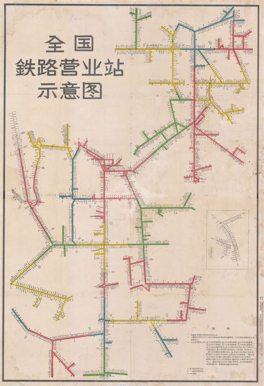
全国鉄路营业站示意图 / National Railroad Schematic Route Map of China.
1959 (dated) 42 x 29 in (106.68 x 73.66 cm)
1959 (dated) 42 x 29 in (106.68 x 73.66 cm)
Description
A remarkable 1957 - 1959 schematic map illustrating the railroads of China. This starkly modern map exhibits no geographical content, rather, in the spirit of London Underground maps of the 1920s and 1930s, focuses exclusively on the railroad network and connections. Text in the lower right describe the rules and regulations of the railroads, noting the fares will go in effect in July of 1959, and establishing a graphic key to understand the map. An inset in the lower right details the narrow gage Kunming-Hekou Railway built by the French between 1904 and 1910. The enormous size and dramatic character of the map suggest that this was made for in-station display, not for private use.
Rare. Stanford has a variant from 1980. This edition of the map is not cited in the OCLC or any other institutional collection. There are likely examples floating around China, but if so we have not been able to isolate them.
Railroads in China
The first railway to be built in China was a 600-metre narrow gauge demonstration line that a British merchant assembled in Beijing in 1864 in hopes of securing a national contract from the Qing government. The Emperor was unimpressed and ordered the railroad disassembled. The next effort, again by the British, was built in 1876 without Qing approval between Shanghai and Woosung (Baohan, Shanghai). Following the First Sino-Japanese War (1894 - 1895), the Qing began to recognize the advantage of railroads, and modern technology in general, and began granting construction contracts. Railroad construction continued throughout the remaining years of the Qing Dynasty and during the Republic of China Period (1912 - 1949). During the Second Sino-Japanese War (1839 - 1945), Japanese companies also built numerous railroads in the occupied territories. After the establishment of the People's Republic of China in 1949, the new government under Mao Zedong invested heavily in the railway network. From the 1950s to the 1970s, railroad lines throughout the country were dramatically expanded. Some lines, particularly in the mountainous regions of southern and western China, were not completed until recently.Publication History and Census
Variations of this map were issued from about 1950 onwards, each exhibiting increasingly complexity of China's railroad network. The map was published and distributed by the People's Railroad Publishing House (人民鉄道出版社) in Beijing. The present example, from 1957- 1959, is scarce and we have identified no other examples. It was initially printed in a quantity of about 20,000.Rare. Stanford has a variant from 1980. This edition of the map is not cited in the OCLC or any other institutional collection. There are likely examples floating around China, but if so we have not been able to isolate them.
Condition
Good. Even toning. Backed on archival tissue. Wear on original fold lines. Minor dampstaining.