This item has been sold, but you can get on the Waitlist to be notified if another example becomes available, or purchase a digital scan.
1919 Masson Map of Turkey Highlighting Where Greeks Live in Asia Minor
RepartitionGrecs-servicegeographique-1919$225.00

Title
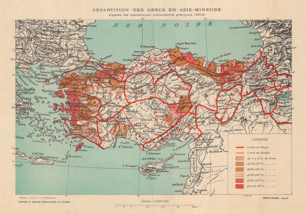
Repartition des Grecs en Asie-Mineure d'apres les statistiques consulaires grecques (1912).
1919 (undated) 12.5 x 17.75 in (31.75 x 45.085 cm) 1 : 4000000
1919 (undated) 12.5 x 17.75 in (31.75 x 45.085 cm) 1 : 4000000
Description
This is a 1919 Service Géographique de l'Armée map of Turkey illustrating Greek populations throughout Anatolia. This piece visualizes Greek influence on the Turkish state in the wake of World War I (1914 - 1918).
A Closer Look
Coverage focuses on Anatolia, but includes parts of the Adjacent Adratic, Turkey in Europe, Greece, the Levant. Overprinted shades of orange represent regions where 'Hellenists' comprise 5-50% of the populace. Although the data is out-of-date, the map, nonetheless, illustrates post-war tensions between the Muslim Turks and Christian Greeks that culminated in the Greco-Turkish War (1919 - 1922).The Greco-Turkish War
The Greco-Turkish War of 1919 - 1922 took place after World War I during the partitioning of the Ottoman Empire. Fought between Greece and the Turkish National Movement, the war ignited after the Greeks landed in Smyrna and took control of western and northwestern Anatolia. The Turks halted the Greek advance in 1921 and, in 1922, broke through the Greek front with a counter-attack. The war ended in October with the capture of Smyrna by Turkish forces. Greece relinquished its territorial gains and returned to the pre-war borders.Publication History and Census
This map was created to accompany P. Masson's 'Smyrne et l'Hellénisme en Asie Mineure' in Questions Européennes and was published as Plate XVIII by the Service Géographique de l'Armée in the accompanying Atlas. The separate map is rare on the market. It does not appear in the OCLC. 4 examples of the entire atlas are cataloged in OCLC and are part of the collections at the Université Bordeaux Montaigne, the Bibliothèque Mazarine, Sorbonne Université and the Bibliothèque Nationale Universitaire de Strasbourg.Cartographer
Service Géographique de l'Armée (1887 - Present) was created from the French Dépot de la Guerre in 1887 and was charged with undertaking all the geodesic, topographic, and cartographic needs of the French army during times of peace and war. The Service was divided into five sections: Geodesy, the Levés de précision, topography, cartography, and accounting. The accounting section dealt with the logistical side of running the Service géographique, including the distribution and shipping of its products. More by this mapmaker...
Source
Martonne, E. Questions Européennes. Belgique Slesvig, Tchécoslovaquie, Pologne et Russie, Questions Adriatique, Yougoslavie, Roumanie, Turquie d'Europe et d'Asie. Atlas, (Paris: Service Géographique de l'Armée) 1919.
Condition
Very good. Light wear along original fold lines.
References
OCLC 1041838104.