This copy is copyright protected.
Copyright © 2025 Geographicus Rare Antique Maps
Digital Image: 1777 First Edition Separate Issue Revolutionary War Map of the United States
RevWarAmerica-moithey-1777_d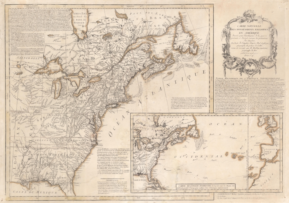

FOR THE ORIGINAL ANTIQUE MAP, WITH HISTORICAL ANALYSIS, CLICK HERE.
Digital Map Information
Geographicus maintains an archive of high-resolution rare map scans. We scan our maps at 300 DPI or higher, with newer images being 600 DPI, (either TIFF or JPEG, depending on when the scan was done) which is most cases in suitable for enlargement and printing.
Delivery
Once you purchase our digital scan service, you will receive a download link via email - usually within seconds. Digital orders are delivered as ZIP files, an industry standard file compression protocol that any computer should be able to unpack. Some of our files are very large, and can take some time to download. Most files are saved into your computer's 'Downloads' folder. All delivery is electronic. No physical product is shipped.
Credit and Scope of Use
You can use your digial image any way you want! Our digital images are unrestricted by copyright and can be used, modified, and published freely. The textual description that accompanies the original antique map is not included in the sale of digital images and remains protected by copyright. That said, we put significant care and effort into scanning and editing these maps, and we’d appreciate a credit when possible. Should you wish to credit us, please use the following credit line:
Courtesy of Geographicus Rare Antique Maps (http://www.geographicus.com).
How Large Can I Print?
In general, at 300 DPI, you should at least be able to double the size of the actual image, more so with our 600 DPI images. So, if the original was 10 x 12 inches, you can print at 20 x 24 inches, without quality loss. If your display requirements can accommodate some loss in image quality, you can make it even larger. That being said, no quality of scan will allow you to blow up at 10 x 12 inch map to wall size without significant quality loss. For more information, it is best consult a printer or reprographics specialist.
Refunds
If the high resolution image you ordered is unavailable, we will fully refund your purchase. Otherwise, digital images scans are a service, not a tangible product, and cannot be returned or refunded once the download link is used.
Maurille Antoine Moithey (March 24, 1732 - December 12, 1810) was a French mathematician, cartographer, globemaker, game designer, and bookseller active in Paris in the mid to late 18th century. Moithey was born in Paris. He held the post of 'Ingénieur géographe du Roi' and professor of mathematics to the pages of the Prince and Princess of Conti. Throughout his long career as a geographer, he was an ardent spokesman for the 'freedom of the seas', particularly as applied to the English Channel. More by this mapmaker...
Jean-Baptiste Crépy (fl. c. 1730 - 1796), also spelled Creepy, was a French map and print publisher based in Paris during the middle of the 18th century. His father Etienne-Louis Crépy, son of Jean Crépy (1660-1739). Within the family dynasty Jean-Baptiste was known as Crépy le Jeune, or Crépy the Younger. His work ranged from maps, such as his reprint of the Le Rouge issue of the Popple Key Map, to general prints, and even geographically themed board games. He is known to have worked with other French mapmakers o the period including André Basset. maintained offices at Rue St. Jacques a St. Pierre near la Rue de la Parcheminerie. The Crépy firm went into bankruptcy and liquidated at auction on the 24th of April, 1790. Jean-Baptiste Crépy died in 1796. Learn More...
Copyright © 2025 Geographicus Rare Antique Maps | Geographicus Rare Antique Maps
This copy is copyright protected.
Copyright © 2025 Geographicus Rare Antique Maps