1767 Isaak Tirion Map of the Rio de la Plata
RioDeLaPlata-tirion-1767$175.00

Title
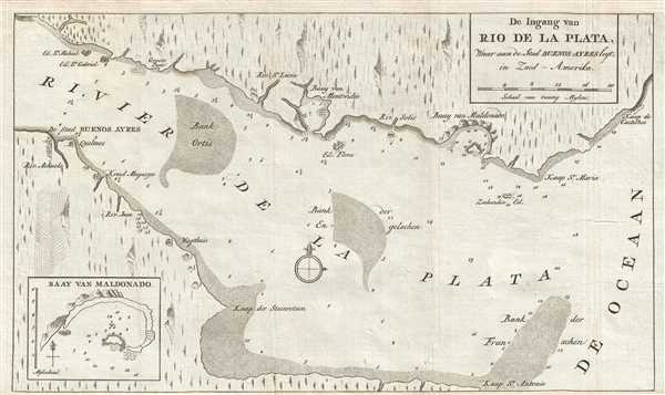
De Ingang van Rio de la Plata, Waar aan de Stad Buenos Ayres legt, in Zuid - Amerika.
1767 (undated) 7.5 x 12.5 in (19.05 x 31.75 cm) 1 : 1730800
1767 (undated) 7.5 x 12.5 in (19.05 x 31.75 cm) 1 : 1730800
Description
This is a 1767 Isaak Tirion map of the Rio de la Plata in South America. The map depicts the Rio de la Plata as it empties into the Atlantic Ocean, with modern-day Uruguay on the top and Argentina on the bottom. Today, the Rio de la Plata forms part of the border between Argentina and Uruguay, with both Buenos Aires and Montevideo situated along its banks. Buenos Aires (Buenos Ayres) is labeled here, whereas Montevideo is absent, apart from the Baay van Montvidio located along the upper bank. Numerous smaller rivers are illustrated emptying into the Rio de la Plata from both banks, with a few of them meriting a label. Several depth soundings are included along both banks and within the Rio de la Plata, with the highest concentration appears in Maldonado Bay in Uruguay. An inset of Maldonado Bay is situated in the lower left corner, including information that Maldonado Bay is a safe harbor.
This map was produced by Isaak Tirion and published in 1767.
This map was produced by Isaak Tirion and published in 1767.
Cartographer
Isaak Tirion (1705 - 1765) was a Dutch publisher in Amsterdam. Born in Utrecht, Tirion quickly rose to prominence by publishing pamphlets, historical works, and most importantly, maps and atlases. He produced several atlases and Dutch town plans. His maps are mainly based on those of Guillaume de l'Isle. Tirion eventually relocated his printing house to the prestigious Kalverstraat. In his long career, he produced eight atlases in multiple editions, some of which were published posthumously until about 1784. More by this mapmaker...
Condition
Very good. Wear along original fold lines. Blank on verso.
References
OCLC 163518191.