This item has been sold, but you can get on the Waitlist to be notified if another example becomes available, or purchase a digital scan.
1751 Portuguese Manuscript Chart of the Rio Grande Lagoa dos Patos Entrance
RioGrandePedro-manuscript-1751$500.00


Title
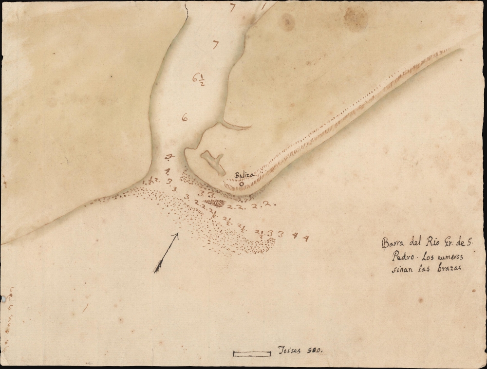
Barra del Rio Gr. de S. Pedro.
1751 (undated) 6.5 x 8.75 in (16.51 x 22.225 cm) 1 : 38000
1751 (undated) 6.5 x 8.75 in (16.51 x 22.225 cm) 1 : 38000
Description
This is an 18th-century Spanish manuscript chart of the entrance to the Rio Grande de San Pedro, on the frontier of Brazil and Uruguay, produced during an extended period of conflict between Spain and Portugal in South America.
The chart's focus is the narrow passage into the Lagoa dos Patos, and it provides soundings in fathoms through the channel between sandbars. The only onshore feature included is a beacon (labeled in Spanish, Baliza) set on the heights overlooking the channel from the north. We see the beacon marked on charts as early as 1751. The following years of conflict led to the fortification of this waterway: The 1777 Tomás Lopez Plano de la entrada del Rio Grande de San Pedro shows a very different picture. By that time, much sharper detail was available for soundings, and each shore of this channel bristled with fortifications. It is not credible that these would be absent here, if it were produced so late. The absence of fortifications advocates for an earlier date, likely prior to the Portuguese establishment of the Captaincy of São Pedro do Rio Grande do Sul in 1760.
A Closer Look
The chart, oriented to the north-northwest, focuses specifically on the entrance of the Lagoa dos Patos, the largest lagoon in Brazil and the largest barrier-lagoon in South America. The lagoon created a bottleneck for any passage up or down the coast, and so this passage represented strategic importance both for its water access to the Rio Grande and also its control over land travel down the coast. Control over the region shifted back and forth between Portuguese Brazil and Spanish La Plata over a period of about 70 years; it is equally possible that this chart was made during a phase in which the mouth of the Rio Grande was under Spanish or Portuguese control.The chart's focus is the narrow passage into the Lagoa dos Patos, and it provides soundings in fathoms through the channel between sandbars. The only onshore feature included is a beacon (labeled in Spanish, Baliza) set on the heights overlooking the channel from the north. We see the beacon marked on charts as early as 1751. The following years of conflict led to the fortification of this waterway: The 1777 Tomás Lopez Plano de la entrada del Rio Grande de San Pedro shows a very different picture. By that time, much sharper detail was available for soundings, and each shore of this channel bristled with fortifications. It is not credible that these would be absent here, if it were produced so late. The absence of fortifications advocates for an earlier date, likely prior to the Portuguese establishment of the Captaincy of São Pedro do Rio Grande do Sul in 1760.
Dating and Sources
We note that this map closely resembles a larger manuscript map embracing more of the entrance to the Lagoa dos Patos, ascribed a date of 1780. As the map lacks the Portuguese fortifications, that is not a credible date. It is obvious that either one is derived from the other or both are derived from the same source. While the present map is in Spanish, the other is in Portuguese; this may support a later a date than ours. In 1763, this region was seized by Spanish forces out of Buenos Aires. The Spanish maintained control of the waterway until 1777, when Johann Heinrich Bohm permanently reasserted Portuguese influence.Watermark
There is partial watermark on the paper visible under light. The mark takes the form of a partial armorial crest and features an 'x' cross and a sheaf of wheat. Although quite elaborate and distinctive, we have not been able to identify this design in watermark databases.Condition
Very good.