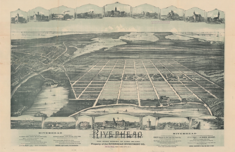
1893 Riverhead Investment Bird's-Eye View Map of Riverhead, Long Island
RiverheadLongIsland-bailey-1893$2,000.00


Title
Riverhead, The Home Resort of Long Island.
1893 (undated) 23 x 34.5 in (58.42 x 87.63 cm)
1893 (undated) 23 x 34.5 in (58.42 x 87.63 cm)
Description
A striking 2-color 1893 chromolithograph view of a speculative community near Riverhead, Long Island, New York. This map was prepared to promote a late 19th-century Long Island Land scam targeting middle-class Brooklynites. The scam lured prospective buyers with 'free' land in a 'lively' town, only to defraud them by collecting 'title and transfer' fees and promoting too-good-to-be-true offers on adjacent lots - none of which actually existed or were developed.
Riverhead Investment Company (RIC) was a real-estate scam launched in April 1893 by Charles M. Russell, Frank H. Adams, and Henry Armstrong. The scam targeted working middle-class Brooklynites.
The RIC began advertising 'Riverhead' properties near Wildwood Lake in the Brooklyn Daily Eagel in the summer of 1893. The terms seemed too good to be true - the first 500 respondents were to receive their land free! Applicants were presented with promotional materials, including the present bird's-eye view, described in a Brooklyn Daily Eagle article dated March 7, 1897.
The 'Riverhead' scam appears to have lasted from 1893 - 1895, but we see the Riverhead Investment Company again active in 1903 - 1907 in Southampton.
City views were being produced in the United States as early as the 1830s, but the genre exploded after the American Civil War (1861 - 1865). Bridging the gap between maps and pictures, most 19th-century American bird's-eye views presented cities to the public from high points. Some were imagined, but others were drawn from hot-air balloons or nearby hills. The presentation, combining high elevation, commercial interest, and new printing technology, created a uniquely American art form, as described by historian Donald Karshan,
A Closer Look
The view looks east by northeast over Long Island from a high point above Wildwood Lake. Central to the image is a gracious planned development. The established city of Riverhead is on the left, across the Peconic River and Bay. The Long Island Sound appears at the far left, Shelter Island on the horizon at the center, and the Hamptons and Shinnecock Bay on the far right.Long Island Land Scams: Boom, Bust, and Imagination
The development of the Long Island Railroad transformed Nassau and Suffolk Counties, Long Island, from hard-to-access rural areas into suburbs of New York City - opening some 400,000 acres of land, all within a short train ride to New York City. Countless existing communities underwent a boom in population, industry, and development. Other new communities popped up seemingly overnight. The fast growth and easy money also attracted speculators and scammers - most in the 1890s.Riverhead Investment Company (RIC) was a real-estate scam launched in April 1893 by Charles M. Russell, Frank H. Adams, and Henry Armstrong. The scam targeted working middle-class Brooklynites.
The RIC began advertising 'Riverhead' properties near Wildwood Lake in the Brooklyn Daily Eagel in the summer of 1893. The terms seemed too good to be true - the first 500 respondents were to receive their land free! Applicants were presented with promotional materials, including the present bird's-eye view, described in a Brooklyn Daily Eagle article dated March 7, 1897.
In presenting its scheme to the public, the Riverhead Investment Company issued a bird's eye view of the country surrounding its property. It represents a town handsomely laid out with a magnificent park running through the middle of it. Riverhead is close at hand; beautiful hotels appear scattered through the territory; the sound is shown on the north while the Atlantic Ocean and the south side hotels appear in close proximity, and Shelter Island, which is really twenty-three miles distant, looms up near at hand.A look at the development site on modern maps reveals no trace of this ambitiously planned town, and the east shore of Wildwood Lake remains only lightly inhabited. It was even less so in 1893. Nevertheless, the advertisements attracted numerous respondents eager to claim the free land. The RIC asked only that applicants pay 'title and transfer' fees, usually about 5 USD. They were then frequently offered a reserved 'adjacent lot' for 25 - 50 USD, which most, thinking it a good deal, purchased upfront. Commenting on a similar land scam, the Brooklyn Daily Eagle estimated the actual value of the undeveloped land to be less than 1 USD per acre.
The 'Riverhead' scam appears to have lasted from 1893 - 1895, but we see the Riverhead Investment Company again active in 1903 - 1907 in Southampton.
Chromolithography
Chromolithography, sometimes called oleography, is a color lithographic technique developed in the mid-19th century. The process uses multiple lithographic stones, one for each color, to yield a rich composite effect. Generally, a chromolithograph begins with a black basecoat upon which subsequent colors are layered. Some chromolithographs used 30 or more separate lithographic stones to achieve the desired effect. Chromolithograph color can be blended for even more dramatic results. The process became extremely popular in the late 19th and early 20th centuries when it emerged as the dominant method of color printing. The vivid color chromolithography made it exceptionally effective for advertising and propaganda.American Bird's-Eye City Views
The Bird's-Eye view industry emerged in the United States in the middle part of the 19th century and coincided with the commercial development of lithographic printing. Before the rise of lithography, the ability to own and display artwork in the home was largely limited to the extremely wealthy, but the advent of lithographic printing made it possible for everyone to own visually striking artwork. A robust trade developed in portraits of political leaders, allegorical and religious images, and city views.City views were being produced in the United States as early as the 1830s, but the genre exploded after the American Civil War (1861 - 1865). Bridging the gap between maps and pictures, most 19th-century American bird's-eye views presented cities to the public from high points. Some were imagined, but others were drawn from hot-air balloons or nearby hills. The presentation, combining high elevation, commercial interest, and new printing technology, created a uniquely American art form, as described by historian Donald Karshan,
Some print connoisseurs believe that it was only with the advent of the full-blown city-view lithograph that American printmaking reached its first plateau of originality, making a historical contribution to the graphic arts. They cite the differences between the European city-view prints and the expansive American version that reflects a new land and a new attitude toward the land.The vogue for bird's-eye city views lasted from about 1845 to 1920, during which period some 2,400 cities were thus portrayed, some multiple times. Although views were produced in many urban centers, the nexus of view production in the United States was Milwaukee, Wisconsin. The major American viewmakers were Stoner, Wellge, Bailey, Fowler, Hill Ruger, Koch, Burleigh, Norris, and Morse, among others.
Publication History and Census
This view was drafted by an unknown artist and published in 1893 by the Riverhead Investment Company. While unattributed, based upon a similar view issued by the 'New York and Brooklyn Suburban Investment Company', we are reasonably confident it is the work of Oakley Hoopes Bailey, one of the most active viewmakers of the period.Cartographer
Oakley Hoopes Bailey (June 14, 1843 - August 13, 1947) was a prolific American viewmaker, artist, and lithographer active in late 19th and early 20th century. Bailey was born in Beloit, Mahoning County, Ohio. He matriculated in 1861 at Mount Union College in Alliance, Ohio, where he studied architecture. At the outbreak of the American Civil War (1861 - 1865) he briefly abandoned his studies for 2 years, wherein he saw combat as a Union solider. After the war, in 1866, he returned to Mount Union to complete his degree. Bailey was the younger brother of another view artist, Howard Heston Bailey (1836 - 1878) and followed his brother into the print business, producing his first city views, of Milwaukee, Wisconsin, in 1871. Active from 1871 to 1926, Bailey is known for more than 375 recorded city views, covering more than 13 states 2 Canadian provinces, making him one of the most active viewmakers in American history. In 1875, he settled in Cambridge, Massachusetts and most of his subsequent work focused on Massachusetts and Connecticut. Bailey worked with many other American viewmakers of the period, including his brother, Howard Heston Bailey, Thaddeus M. Flower, and J. C. Hazen, among others. Even his wife, Sarah F. Bailey (1846 - 19??) got into the business, drawing at least one view, of Watkins Glen, New York. Around 1904, by this time in his 60s, Bailey entered into a publishing partnership with Thomas S. Hughes, publishing their 'aero-views' as 'Hughes and Bailey'. Together, Hughes and Bailey revisited the sites of many of Bailey's early views, remaking them sometimes 20 - 40 years later, the idea being to set them beside the earlier views to show how much the respective towns had changed. The partnership lasted until about 1926. Bailey died in his hometown of Alliance at the ripe old age of 103. More by this mapmaker...
Condition
Very good. Thin paper laid down on archival tissue. Some additional archival verso reinforcements.
References
OCLC 762052616. New York Public Library, b20645981 / Map Div. 16-6154. Library of Congres, G3804.R52A3 1890 .R5. Reps, John, Views and Viewmakers of Urban America (University of Missouri, Columbia, 1984), #2900.