This item has been sold, but you can get on the Waitlist to be notified if another example becomes available, or purchase a digital scan.
1860 Naymiller / Allodi Chart of Comparative Rivers and Waterfalls
RiversWaterfalls-naymiller-1860$250.00

Title
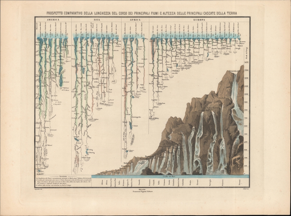
Prospetto comparativo della lunghezza del corso dei principali fiumi e altezza delle principali cascate della terra.
1860 (undated) 13.25 x 15.75 in (33.655 x 40.005 cm)
1860 (undated) 13.25 x 15.75 in (33.655 x 40.005 cm)
Description
A hand-colored 1860 comparative chart of world rivers and waterfalls, prepared by Filippo Naymiller and engraved by Pietro Allodi. This is one of the few examples of a comparative geographical chart published in Italian.
A Closer Look
The upper-left half of the sheet consists of the world's longest rivers, divided by continent, with riverside cities and settlements, forts, tributaries, adjoining lakes, and mountains near the source noted. At bottom-right is a depiction of the world's tallest waterfalls emanating from a mountain, with their height noted in 'Parisian' (French) feet. The note at bottom-left explains the placement of the Amazon first among American rivers, even though the Mississippi is longer (at least by terms employed here). The determination of the length of rivers would change somewhat in the following decades as measurements improved and Europeans gained a better understanding of the interior of other continents. Most notably, Lake Victoria had only just been discovered by Europeans in 1858, setting off a heated debate among Britain's geographic community. It was not firmly established as the source of the Nile for some years afterward.Publication History and Census
This chart was prepared by Filippo Naymiller, engraved by Pietro Allodi, and published by Francesco Pagnoni in Milan around 1860. It may have appeared in the scarce atlas Atlante universale di geografia antica e moderna. In any event, this chart is only cataloged in the OCLC among the holdings of the Staatsbibliothek zu Berlin.CartographerS
Filippo Naymiller (fl. c. 1840 - 1890) was an Italian cartographer and artist active in Milan in the mid-19th century. The details of his life are obscure and contested. He is sometimes noted as being British on account of his surname, but seemingly spent his entire life in Italy. While most sources agree he was born in 1804, spent the majority of his life in Milan, and later relocated to Pavia, some sources list him as dying in 1863, but works under his name appeared regularly into the late 1860s and as occasionally afterwards until 1890. More by this mapmaker...
Pietro Allodi (fl. 1859-1878) was an Italian author, engraver, and illustrator; despite his having been apparently prolific in Milan - working for a number of different publishers, including Ferdinand Artaria - virtually nothing is known of his life and his training. Learn More...
Source
Potel, F., Atlante universale di geografia antica e moderna, (Napoli: FP Litpgrafo) 1850.
Condition
Very good.
References
OCLC 248695647.