This item has been sold, but you can get on the Waitlist to be notified if another example becomes available, or purchase a digital scan.
1845 Delamarche Map of the Roman Empire under Augustus
RomanEmpireDiocletian-delamarche-1850$50.00

Title
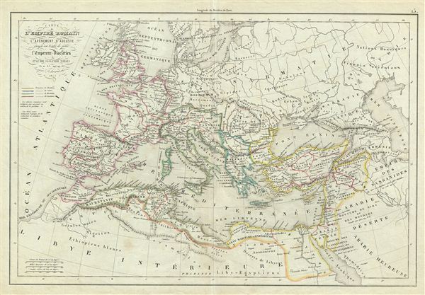
Carte de l'Empire Romain depuis l'Avenement d'Auguste jusqu'au traite de paix entre l'Empereur Diocletien et le Roi Sassanide Narses.
1845 (dated) 12.5 x 18 in (31.75 x 45.72 cm)
1845 (dated) 12.5 x 18 in (31.75 x 45.72 cm)
Description
This is a beautiful example of Alexandre Delamarche's 1845 map of europe under the Roman empire from the time of Augustus Caesar to the signing of the peace treaty between emperor Diocletian and the Sassanid King Narseh. It covers all of europe from the Atlantic Ocean to Asia, and from the Arctic to northern Africa showing the extent of the Roman empire at its height, including most of europe, the Middle east, Persia and parts of north Africa.
The empire was established in 27 BC after Gaius Julius Caesar Octavianus, the grandnephew and heir of Julius Caesar was awarded the honorific title of Augustus. During the time of the empire, Roman cities flourished with a global trade network spread as far as India, Russia, China and Southeast Asia. However, the sheer size of the empire and its success also contributed to its downfall. The Western Roman empire collapsed in AD 476, when Romulus Augustulus was deposed by the German Odovacer. The eastern Roman empire, evolving into the Byzantine empire, survived until the Ottoman Turks captured Constantinople in 1453.
Throughout, the map identifies various cities, towns, rivers, mountain passes and an assortment of additional topographical details. Political and regional borders are highlighted in outline color. This map was issued by Delamarche as plate no. 15 in his Atlas Delamarche Geographie Modern.
Cartographer
Charles-François Delamarche (August 1740 - October 31, 1817) founded the important and prolific Paris-based Maison Delamarche map publishing firm in the late 18th century. A lawyer by trade, Delamarche entered the map business with the 1787 acquisition from Jean-Baptiste Fortin of Robert de Vaugondy's map plates and copyrights. Delamarche appears to have been of dubious moral character. In 1795, the widow of Didier Robert de Vaugondy, Marie Louise Rosalie Dangy, petitioned a public committee for 1500 livres, which should have been awarded to her deceased husband. However, Delamarche, proclaiming himself Vaugondy's heir, filed a simultaneous petition and walked away with the funds, most of which he was instructed to distribute to Robert de Vaugondy's widow and children. Just a few months later, however, Delamarche proclaimed Marie Dangy deceased, and it is highly unlikely that any funds found their way to Robert de Vaugondy's impoverished daughters. Nonetheless, where Robert de Vaugondy could barely make ends meet as a geographer, Delamarche prospered as a map publisher, acquiring most of the work of earlier generation cartographers Lattre, Bonne, Desnos, and Janvier, thus expanding significantly upon the Robert de Vaugondy stock. Charles Delamarche eventually passed control of the firm to his son Felix Delamarche (c. 1750 - c. 1850) and geographer Charles Dien (1809 - 1870). It was later passed on to Alexandre Delamarche, who revised and reissued several Delamarche publications in the mid-19th century. The firm continued to publish maps and globes until the middle part of the 19th century. More by this mapmaker...
Source
Delamarche, A., Atlas Delamarche Geographie Ancienne et Moderne, (Paris) 1850.
Condition
Very good. Some wear on original centerfold. Blank on verso.