This item has been sold, but you can get on the Waitlist to be notified if another example becomes available, or purchase a digital scan.
1962 Air India Route Map of the World
RouteMap-airindia-1955$97.50

Title
Air India Route Map.
1955 (undated) 9 x 15 in (22.86 x 38.1 cm)
1955 (undated) 9 x 15 in (22.86 x 38.1 cm)
Description
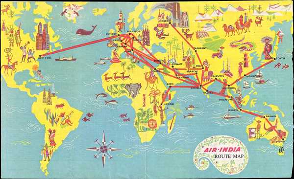
This is a 1962 Air India route map of the world. The map depicts six of the seven continents, excluding Antarctica, in an almost cartoonish manner. Aiming to portray the various different locations where Air India flies, the map presents stereotypical caricatures of these cities. London, for example, is portrayed by Big Ben and a Buckingham Palace, Paris by a man in a striped shirt and beret playing the accordion. Moscow, however, is depicted using a cosmonaut and Saint Basil’s Cathedral, which is in Red Square. India, which includes flights to Bombay, Calcutta, Madras, and Delhi, is represented by a wealthy man riding on an elephant’s back. As far as Air India’s service goes, New York is the only city in the Americas where they fly, with a single route between New York and London. North America definitely varies in caricatures, though, from the skyscrapers of New York City, to the jazz musicians of New Orleans, and the Native Americans and cowboys of the West, the last two undoubtedly internationally recognizable stereotypes. South America is not served at all by Air India, and the caricatures depict a society much like the American West: simple, having not quite arrived in the twentieth century. Except for the oil derricks, South American life is presented similarly to the American West, as having not yet arrived in the twentieth century. Africa is depicted as a wild, untamed continent, with buildings only associated with Nairobi, Kenya, much in the same way as North America only appears to be civilized in New York City. Hong Kong and Tokyo are both presented in a way that evokes stereotypical connotations of those cities and civilizations, as in keeping with the rest of the map. Australia, which is introduced by the Sydney Harbor Bridge, a cowboy tending to sheep, and a kangaroo, doesn’t change the overall tone of the map, only reinforces it.
This map was produced by Air India c. 1962. Although this map is not dated, we used the information provided on the verso to give an approximate date for the map, specifically the emphasis on the use of Lockheed Super Constellations on their international routes along with the presence of a cosmonaut. Yuri Gagarin, the first cosmonaut, became the first human in space in 1961.
This map was produced by Air India c. 1962. Although this map is not dated, we used the information provided on the verso to give an approximate date for the map, specifically the emphasis on the use of Lockheed Super Constellations on their international routes along with the presence of a cosmonaut. Yuri Gagarin, the first cosmonaut, became the first human in space in 1961.
Condition
Very good. Information about Air India service on verso.