1768 Vaugondy Map of Denmark
RoyaumeDanemarck-vaugondy-1768$400.00

Title
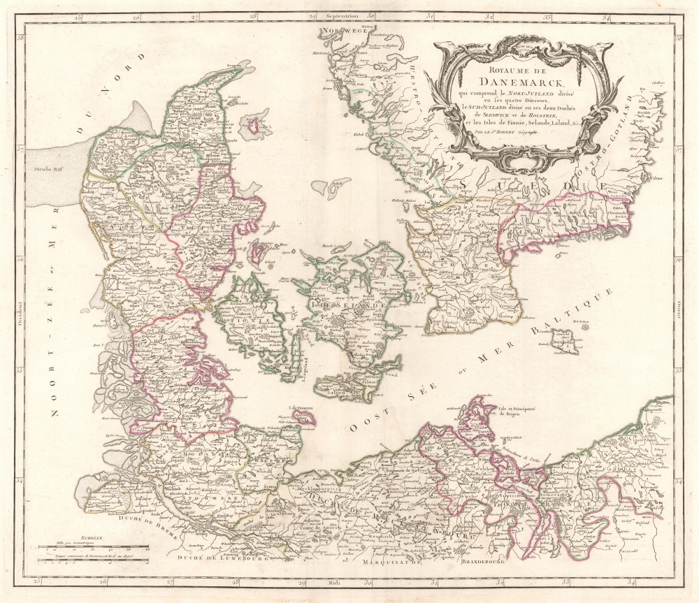
Royaume de Danemarck, qui comprend le Nort-Jutland divisé en ses quatre Dioceses, le Sud-Jutland divisé en ses deux Duchés de Sleswick et de Holstein, et les Isles de Fionie, Selande, Laland, etc.
1768 (undated) 19.5 x 22.5 in (49.53 x 57.15 cm) 1 : 1180000
1768 (undated) 19.5 x 22.5 in (49.53 x 57.15 cm) 1 : 1180000
Description
This is a c. 1768 Didier Robert de Vaugondy map of Denmark. Vaugondy's work presents a high degree of accuracy (for the period) since the Atlas Universel in which it was printed was one of the first atlases based upon actual surveys.
A Closer Look
The map depicts all of Jutland and the islands of Zealand, Funen, and Lolland. The southernmost part of Sweden occupies the upper right quadrant (along with the decorative title cartouche), and northern Germany appears along the bottom border (then a collection of duchies, principalities, and other polities). Cities, towns, and villages are identified throughout the depicted region, including in Sweden and Germany. Lakes and rivers are illustrated (although most are not labeled). Dioceses within Denmark are outlined in beautiful hand color.Publication History and Census
This map was created and published by Didier Robert de Vaugondy c. 1768 in his Atlas Universel. This is the second state of the map, with the first state first appearing in 1750. This map in both its states is well represented in institutional collections, although nearly all are cataloged as dating from 1750, making an accurate census of the second state very difficult.Cartographer
Robert de Vaugondy (fl. c. 1716 - 1786) was French may publishing from run by brothers Gilles (1688 - 1766) and Didier (c. 1723 - 1786) Robert de Vaugondy. They were map publishers, engravers, and cartographers active in Paris during the mid-18th century. The father and son team were the inheritors to the important Nicolas Sanson (1600 - 1667) cartographic firm whose stock supplied much of their initial material. Graduating from Sanson's maps, Gilles, and more particularly Didier, began to produce their own substantial corpus. The Vaugondys were well-respected for the detail and accuracy of their maps, for which they capitalized on the resources of 18th-century Paris to compile the most accurate and fantasy-free maps possible. The Vaugondys compiled each map based on their own geographic knowledge, scholarly research, journals of contemporary explorers and missionaries, and direct astronomical observation. Moreover, unlike many cartographers of this period, they took pains to reference their sources. Nevertheless, even in 18th-century Paris, geographical knowledge was limited - especially regarding those unexplored portions of the world, including the poles, the Pacific Northwest of America, and the interiors of Africa, Australia, and South America. In these areas, the Vaugondys, like their rivals De L'Isle and Buache, must be considered speculative or positivist geographers. Speculative geography was a genre of mapmaking that evolved in Europe, particularly Paris, in the middle to late 18th century. Cartographers in this genre would fill in unknown lands with theories based on their knowledge of cartography, personal geographical theories, and often dubious primary source material gathered by explorers. This approach, which attempted to use the known to validate the unknown, naturally engendered rivalries. Vaugondy's feuds with other cartographers, most specifically Phillipe Buache, resulted in numerous conflicting papers presented before the Academie des Sciences, of which both were members. The era of speculative cartography effectively ended with the late 18th-century explorations of Captain Cook, Jean Francois de Galaup de La Perouse, and George Vancouver. After Didier died, his maps were acquired by Jean-Baptiste Fortin, who in 1787 sold them to Charles-François Delamarche (1740 - 1817). While Delamarche prospered from the Vaugondy maps, he defrauded Vaugondy's window Marie Louise Rosalie Dangy of her rightful inheritance and may even have killed her. More by this mapmaker...
Source
Robert de Vaugondy, G., Atlas Universel, (Paris) 1757.
The Atlas Universel was the crowning glory of the Robert de Vaugondy firm's atlas production. The atlas was revolutionary on many levels and exemplified the Vaugondy credo commode, complet, univorme, et suive (convenient, complete, uniform, and easy to use). The atlas thus consisted of a wide corpus of maps, both modern and historical, was of moderate height and width, and featured maps of uniform style and structure. They partnered with Antoine Boudet, a shrewd businessman and publisher with whom they had worked previously, to produce the 1752 first edition. To minimize his fiscal risk, Boudet sold the atlas first by subscription using a large prospectus, receiving in the process over 1100 pre-orders. The first edition appeared in 1752 and contained beautifully produced maps with elaborate freshly designed allegorical cartouche work, generally by Pierre-Edme Babel, Pierre Philippe Choffard, and Charles Nicholas Cochin. Most of the maps were engraved by the Delahaye firm, the payment for whose services ultimately led to legal disputes. Despite proving a popular work of astounding quality, the Atlas Universal received harsh criticism from fellow cartographers, particularly Philipppe Buache. Ever at odds with the Vaugondys, Buache's critical perspective may have been influenced more by political maneuvering than academic affront. The atlas was issued in multiple editions between 1752 and 1788. Later editions, issued after 1786, were taken over by Charles Delamarche, who inherited the Robert de Vaugondy firm and assumed Boudet's publication rights.
Condition
Very good. Light wear along original centerfold. Verso repairs to centerfold separations. Closed margin tears professionally repaired on verso.
References
Pedley, Mary Sponberg, Bel et Utile: The Work of the Robert de Vaugondy Family of Mapmakers #72 State 2.