This copy is copyright protected.
Copyright © 2025 Geographicus Rare Antique Maps
Digital Image: 1730 Strahlenberg Map of Russia, Siberia, and Asian Arctic
Russia-strahlenberg-1730_d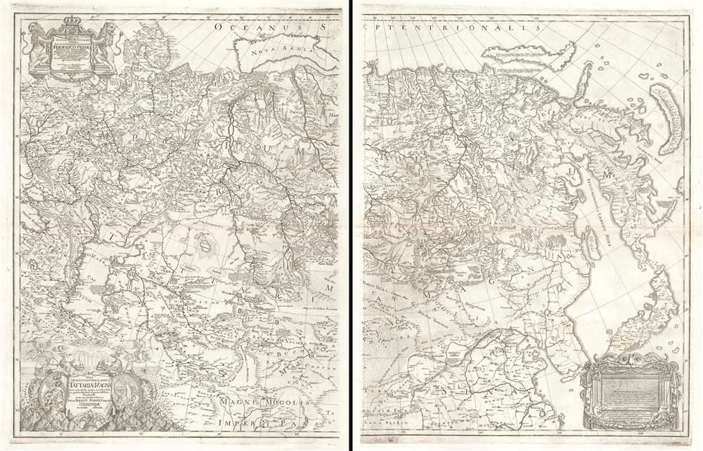

FOR THE ORIGINAL ANTIQUE MAP, WITH HISTORICAL ANALYSIS, CLICK HERE.
Digital Map Information
Geographicus maintains an archive of high-resolution rare map scans. We scan our maps at 300 DPI or higher, with newer images being 600 DPI, (either TIFF or JPEG, depending on when the scan was done) which is most cases in suitable for enlargement and printing.
Delivery
Once you purchase our digital scan service, you will receive a download link via email - usually within seconds. Digital orders are delivered as ZIP files, an industry standard file compression protocol that any computer should be able to unpack. Some of our files are very large, and can take some time to download. Most files are saved into your computer's 'Downloads' folder. All delivery is electronic. No physical product is shipped.
Credit and Scope of Use
You can use your digial image any way you want! Our digital images are unrestricted by copyright and can be used, modified, and published freely. The textual description that accompanies the original antique map is not included in the sale of digital images and remains protected by copyright. That said, we put significant care and effort into scanning and editing these maps, and we’d appreciate a credit when possible. Should you wish to credit us, please use the following credit line:
Courtesy of Geographicus Rare Antique Maps (http://www.geographicus.com).
How Large Can I Print?
In general, at 300 DPI, you should at least be able to double the size of the actual image, more so with our 600 DPI images. So, if the original was 10 x 12 inches, you can print at 20 x 24 inches, without quality loss. If your display requirements can accommodate some loss in image quality, you can make it even larger. That being said, no quality of scan will allow you to blow up at 10 x 12 inch map to wall size without significant quality loss. For more information, it is best consult a printer or reprographics specialist.
Refunds
If the high resolution image you ordered is unavailable, we will fully refund your purchase. Otherwise, digital images scans are a service, not a tangible product, and cannot be returned or refunded once the download link is used.
Philipp Johann von Strahlenberg (October 6, 1677 - September 7, 1747), aka Philip Johan Tabbert, was a Swedish army officer of Germanic descent. Strahlenberg was born in the Hanseatic town Stralsund, now Pomerania, Germany, but then part of Sweden. Strahlenberg joined the Swedish army in 1694, being promoted to Captain in 1703. When he was ennobled in 1707, he took the name Strahlenberg. During the Great Northern War (1700 - 1721) between Russia and Sweden, Strahlenberg was captured and sent to Tobolsk, where he lived the commodious life of a noble prisoner of war from 1711 to 1721. During this time, he developed a fascination with the the geography of Siberia and studied the anthropology, languages, and customs of its indigenous peoples. He also worked as an assistant to the German explorer and naturalist Daniel Gottlieb Messerschmidt (1685-1735), who was then working for Peter the Great. Along with fellow Swedish prisoner, Johan Anton von Matérn, Strahlenberg dedicated himself to the composition of a large new map of Russia. Strahlenberg recommended that the Ural Mountains serve as the eastern borders of the European continent, an idea that was later approved by the Tsar. He returned to Sweden in 1722, and in 1730 he published an important book about Siberia, Das Nord- und Ostliche Theil von Europa und Asia (North and Eastern Parts of Europe and Asia), and its accompanying map. More by this mapmaker...
Johan Anton von Matérn (October 22, 1683 - December 20, 1764) was a Swedish military officer and cartographer active in the late 17th and first half of the 18th century. Matérn was born in Stockholm. He joined the military sometime around 1704, rapidly raising through the ranks. In 1708 he led a detachment to make maps of Poland, Samogitia and Lithuania. He was captured by Russia forces during the Battle of Perevolotjna (1709) during the During the Great Northern War (1700 - 1721) and, along with Philipp Johann von Strahlenberg (1676 - 1747), sent to Tobolsk, Siberia. He returned to Sweden in 1722. Matérn worked with Strahlenberg to produce a new map of Russia, which the issued in 1730. Learn More...
Philipp Jacob Frisch (1702 - December 4, 1753) was a German lawyer, painter, and map engraver based in Berlin. Frisch was the son of the ornithologist and linguist Johann Leonard Frisch. He studied painting under Samuel Gottlieb Hanrich and Wilhelm Busch. Frisch had two brothers, the Protestant priest Just Leopold Frisch, and fellow engraver, Ferdinand Helfreich Frisch. The family is best known for their production of a large and graphic book about the birds and insects of Germany, begun by Johann Leonard, but completed by his sons, and grandson, the painter Johann Christoph Frisch. Philipp Jacob Frisch also engraved Strahlenberg's 1730 map of Russia. Learn More...
Copyright © 2025 Geographicus Rare Antique Maps | Geographicus Rare Antique Maps
This copy is copyright protected.
Copyright © 2025 Geographicus Rare Antique Maps