1931 Papelaria Brazileira City Plan of Salvador, Brazil
SalvadorBahia-papelariabrazileira-1931$500.00

Title
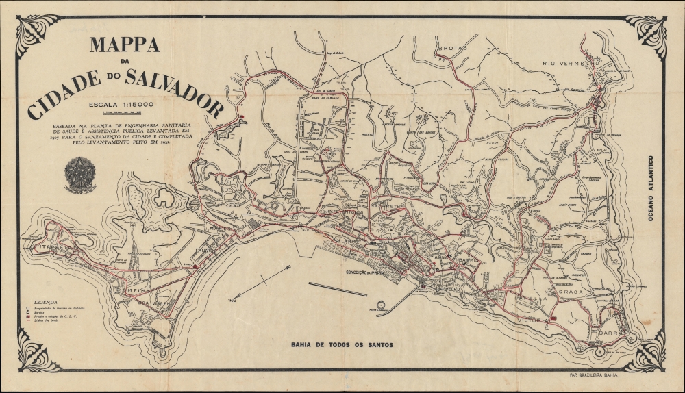
Mappa da cidade do Salvador.
1931 (dated) 16.25 x 30 in (41.275 x 76.2 cm) 1 : 15000
1931 (dated) 16.25 x 30 in (41.275 x 76.2 cm) 1 : 15000
Description
An intriguing 1931 city plan or map of Salvador, Bahia, Brazil, produced by the local publisher Papelaria Brazileira. It presents the city during a time of modernization and transformation, especially in the historic city center.
The historic city center was undergoing a wholesale redevelopment in the early 1930s, which unfortunately included the demolition of Salvador's 16th-century cathedral (with the approval of Archbishop Augusto da Silva), located where three concurrent churches are seen here, to allow tram lines to enter the area. The completion of the modern port, hinted at here, allowed more large steamships from distant ports to call at Salvador.
A Closer Look
Oriented towards the southeast, this city plan labels streets, neighborhoods, government buildings, churches, cemeteries, rail lines, fortifications, important institutions (such as hospitals, schools, and train stations), waterways, markets, and more. The city's extensive network of streetcar lines is traced in red. At bottom-center are several blocks of ghosted-in streets; these would eventually be built and form the basis of the city's modern port facilities. Some areas are labeled with curious notes, such as 'campo experimental' on the right and a favela (shantytown) at the center-left. The text below the title reads: 'Based on the health engineering and public assistance plan created in 1905 for the city's sanitation and completed by the survey carried out in 1931.'Building 'Black Rome'
As Brazil's original colonial capital, Salvador is one of the oldest European-influenced cities in the Americas. Since it was an important trading port and was especially central to the Transatlantic Slave Trade, most of the city's residents have at least partial African ancestry, and it is a center of Afro-Brazilian culture commonly known as 'Black Rome.' Beginning in the 1870s, Salvador saw a series of modernization projects, including railways, pedestrian elevators, streetcars (horse-pulled at first, then pulled by steam locomotives, and finally electrified around the turn of the century), schools, museums, sanitation infrastructure, electricity and more.The historic city center was undergoing a wholesale redevelopment in the early 1930s, which unfortunately included the demolition of Salvador's 16th-century cathedral (with the approval of Archbishop Augusto da Silva), located where three concurrent churches are seen here, to allow tram lines to enter the area. The completion of the modern port, hinted at here, allowed more large steamships from distant ports to call at Salvador.
Publication History and Census
This map was prepared by Salvador's municipal government in 1931 and printed shortly after by Papelaria Brazileira. (The inclusion of both the old cathedral and the tram lines in the city center indicates a date no later than 1933 when the cathedral was demolished). It is scarce, with only one institutional listing in the OCLC (at the University of California Los Angeles) and no known history on the market.Cartographer
Papelaria Brazileira (c. 1920 - 1936), also written as Papelaria Brasileira, was a printer and publisher based in Bahia, Brazil. Little is known of the company's history and its surviving output is quite limited, but it appears to have mostly produced official reports and maps for the government of the state of Bahia, though its most influential publication was unquestionably Manuel Querino's A Arte Culinária na Bahia (1928), an important work in documenting Afro-Brazilian culture. More by this mapmaker...
Condition
Good. Wear and foxing along original folds. Light soiling on bottom right quadrant. Slight worming along centerfold near bottom.
References
OCLC 987380281.