This item has been sold, but you can get on the Waitlist to be notified if another example becomes available, or purchase a digital scan.
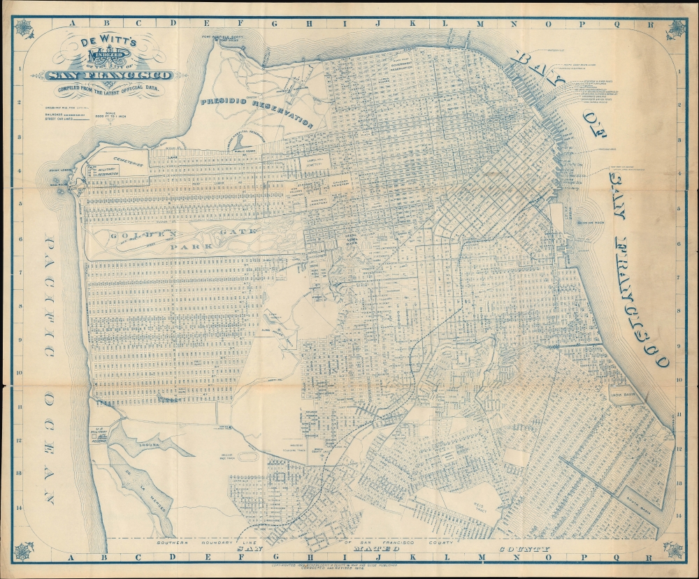
1904 De Witt Map of San Francisco on the Eve of the 1906 Earthquake
SanFrancisco-dewitt-1904
Title
1904 (dated) 20.5 x 25 in (52.07 x 63.5 cm) 1 : 23000
Description
A Closer Look
The city is presented in its early 20th century incarnation, expanding rapidly and crisscrossed by streetcar and cable car lines in the densely populated center of the city. Circles emanate from City Hall on Market St. in half-mile intervals. Piers are numbered and ferry lines labelled, most terminating at the iconic Ferry Building (completed 1898). The contours of the city are clearly recognizable, even if portions of it would change substantially in the following years.The western and southern part of the city are captured as they were being planned for development. Although the course of the streets in the Richmond and Sunset Districts are laid out here, there was very little in the way of actual buildings there, especially in the Sunset, which at this time mostly consisted of sand dunes. This fact explains the ghosting in of streets over extant waterways there. One particularly significant feature in the Inner Sunset is the 'U.C. Affiliated Colleges' (relocated in 1898), an early appearance of what would become the Parnassus Campus of the University of California San Francisco.
Streets are lettered alphabetically in the Richmond, Sunset, and Bayview; these letters were later elaborated to full names (Anza, Balboa, Cabrillo; Hawes, Ingalls, Jennings, and so on). The Reis Tract near bottom mostly became McLaren Park; nearby University Mound was named such because it had been the site of a failed seminary before it was purchased by local grandee James Lick (the wealthiest man in California in the 1870s) and donated to found a home for widows and elderly women.
Adolph Sutro and His Steam Railroad
In the years before this map's publication, one of the most influential and colorful figures in the city was Adolph Sutro (1830 - 1898), a populist millionaire and mayor from 1895 to early 1897. The Sutros, a Jewish family in Aachen, fled Germany following the failed revolutions of 1848 and settled in the United States; soon afterwards, Adolph made his way to California in the wake of the Gold Rush. But Sutro's fortune came from silver, not gold, more specifically the Comstock Lode along the California-Nevada border. Sutro devised a much-improved method for draining water from mines, a serious problem inhibiting the exploitation of resources.Sutro then returned to San Francisco and invested in real estate and various other ventures. The most memorable was the Sutro Baths, a seaside bathhouse adjacent to his own estate that was the largest indoor swimming pool in the world when opened in 1896. The same year, Sutro opened a majestic new Cliff House on the site of a eponymous building that had burned down at the same site. He then built a steam railway (the Cliff House Steam Railroad, seen running down California St. here) to quickly carry passengers from the main part of the city to the coast, which was sparsely inhabited at the time. The line, which included some harrowing cliffside turns along the coast (the area now known as Land's End), was electrified in 1905 and was in use until a portion collapsed in a landslide in 1925.
These projects, along with his various other enterprises and estates, including a hill beneath the Parnassus campus of the University of California where he planted eucalyptus (now Sutro Forest), have left a deep imprint on the city even down to the present.
A City for the Living
One oddity to a modern resident of San Francisco is the prevalence of cemeteries here. Given the rapid growth of the city at this time and the limited amount of space for new development, along with public health concerns, in 1901 the city barred the burial of any dead bodies within city limits. In the following decades, the graves in the city's existing cemeteries were relocated to Colma, some 10 miles to the south, and the land repurposed for other uses (including a golf course and the University of San Francisco). Only a small number of exceptions were made, such as for historic graves around Mission Delores, the Columbarium of the Odd Fellows Cemetery (too big to move), and the cemetery in the middle of the Presidio, which, as federal land, was exempt from the city's ordinance (now the San Francisco National Cemetery, it remains the only place to legally accept new burials within city limits).Publication History and Census
This map was published by Frederic M. De Witt in several editions at the turn of the 20th century, with the first edition appearing in 1898, and subsequent editions appearing in 1899, perhaps 1903, and 1904. It appears to have been both separately issued and issued as part of a larger guidebook published by De Witt (An illustrated and descriptive souvenir and guide to San Francisco). Regardless of edition, the map is quite scarce now, with the current edition (seemingly the most common among surviving examples) being held by the Huntington Library, Yale University, the New York Public Library, and Lake Forest College.Cartographer
Frederic M. De Witt (fl. c. 1890 – 1930) was a publisher based in the San Francisco Bay Area in the late 19th and early 20th centuries. Little details are available about De Witt's life and training. He appears in San Francisco city directories beginning in 1890, listed as a salesman, but by the late 1890s he was publishing maps and guidebooks of his home city. He appears to have later relocated to Alameda in the East Bay. There is limited evidence that he continued to publish books, though not the maps and guidebooks of his earlier years. He may have also played a role in establishing Joaquin Miller Park in Oakland. More by this mapmaker...

