Title
Faust's Map of City and County of San Francisco California.
1892 (dated)
24.5 x 30.5 in (62.23 x 77.47 cm)
1 : 23100
Description
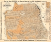
This is Henry W. Faust's 1892 map of San Francisco, California, demonstrating the growth and planned future expansion of America's western metropolis.
A Closer Look
The map covers the entire city of San Francisco, including both extant urban development at the time of publication and planned future developments (variously named homesteads, additions, tracts, reservations, and others). It records a remarkable level of detail, down to numbering individual city blocks. Concentric circles radiate at a half-mile from the ferry landing at the end of Market St., where the iconic Ferry Building would be constructed in the following years. An inset map at the top-right displays the wider San Francisco Bay Area. Cable car, street car, and rail lines are noted according to the legend at right. San Francisco boasted an impressive public transportation network at this time, with cable cars being a major innovation. Lines along Market St. and other relatively flat parts of the city were being actively transitioned from horse-pulled to steam-powered and then electrified. Urban-suburban railways pulled by steam locomotives provided connections along Golden Gate Park and to the western end of the city. The Ferries and Cliff House Railway (also known as the Cliff House Steam Railroad) ran to a cluster of attractions, including Sutro Baths, the Cliff House, and Seal Rocks (the train ride along cliffs facing the Golden Gate and the Marin Headlands, was said to be an experience in itself, captured in a 1902 film reel titled 'Panoramic View of the Golden Gate' by Thomas Edison Inc.). Adolph Sutro
These attractions were all connected to millionaire Adolph Sutro and his estate, which occupied the northwest corner of the city. A German-born Jew who engineered the tunnel allowing for the exploitation of the Comstock Lode, Sutro had an inexhaustible drive to take on new projects, including philanthropic ones. An altogether unique product of the era and city, Sutro successfully ran for mayor in 1894 on a Populist, anti-big business platform despite being one of the city's richest men. Much of his criticism was directed towards the city's political machine, which historically pandered to the Southern Pacific Railroad.
As a case in point, the Park and Ocean Railroad running along the south side of Golden Gate Park was owned by the Central Pacific Railroad (of Transcontinental Railroad fame). The Central Pacific was the predecessor to the Southern Pacific and was owned by the same 'Big Four' railroad barons who also owned the Southern Pacific (which, somewhat confusingly, bought the Central Pacific in 1885). Despite the Central Pacific's heft, state-appointed board of commissioners of Golden Gate Park had successfully opposed the construction of the Park and Ocean Railroad for several years. That is, until 1882, when Frank Pixley, the politically-connected newspaperman and operative for the Big Four, was appointed to the board and engineered its takeover. Soon afterwards, none other than Leeland Stanford also joined the park commission, and the Park and Ocean Railroad was quickly approved.The Best Laid Plans…
The Richmond and Sunset ('South Side') Districts were more concept than reality at this point, as the ghosted in 'Central Ocean Road' and waterways in the latter demonstrates, though the grid laid out here was largely followed (with exceptions made for parks, reservoirs, and schools). The Sea Cliff neighborhood, between the City Cemetery and the Presidio, was ultimately built with more 'charming' winding streets, adding to the area's exclusive feel. Similarly, the Marina District to the east of the Presidio did not develop quite as planned here, as it was still in the process of being reclaimed from the water, and what did exist was severely damaged by the 1906 earthquake. Much of the innermost portion of the Richmond District near the northeast corner of Golden Gate Park also changed considerably, with the cemeteries removed and relocated to Colma, south of San Francisco, the street grid remade, the streets renamed, and the land used for the University of San Francisco and new housing developments. Ghosted features also harken to the city's past as well as its future, as the 'original water front line' along the northern and eastern edge of the city and the inclusion of the names of the city's original Spanish and Mexican ranchos demonstrates.
As with the Richmond and Sunset Districts, most of the southern and western parts of the city, the Mission District and, to a lesser extent, Potrero Hill excepted, generally had limited existing urban development at this time. This is the reason for the appearance of city blocks abruptly ending part-way into undeveloped land. For similar reasons, parts of the city appear odd to a modern resident because the layout was not yet finalized. For instance, on the east side of Twin Peaks near Horner's Addition (now Noe Valley), several 'wiggly' streets appear that were, in fact, never constructed. In the same area, a faintly drawn extension of Market Street beyond its intersection with Castro St. can also be seen, closer to the ultimate configuration of streets in this area. Faust seems to imagine a Market St. tunnel passing under Twin Peaks, a long-discussed project that was completed (the Twin Peaks Tunnel) in the 1910s and remains an essential part of the city's public transit infrastructure. Similarly, a 'Right of Way for Western Southern Pacific' cuts right through city blocks in the area south of Islais Creek Channel, in today's Bayview-Hunters Point neighborhoods.
In brief, this map reflects the state of the city as being roughly divided in half, a tightly-packed urban core in the northeastern part of the city that developed in the wake of the Gold Rush, and its sparsely-settled hinterland of steep hills and sand dunes that was clearly destined for future growth, though the exact contours of that growth were still indeterminate. Ambitious 'City Beautiful' plans imagined remaking the city, having it flow more naturally with its dramatic landscape rather than impose an artificial and often inconvenient grid onto a series of hills. Most notably, the 1905 Burnham Plan considered a radical transformation of the city into a new Athens or Paris, which would have unquestionably resulted in the most beautiful, or at least most grandiose, city in the Americas. These schemes were spoiled by the 1906 Earthquake and Fire, and many of the homesteads and other developments imagined here were instead built as posh 'residence parks' or garden suburbs in the early 20th century, such as St. Francis Wood and Ingleside Terraces. Publication History and Census
This map was prepared by Henry W. Faust and lithographed by William T. Galloway. It was typically issued folded in one of several presentations, with Faust's guide or separately-issued, as explained at right below the legend (for a variant printing without the surrounding advertisements, see Rumsey 1831.002). The present example is in especially good condition, with minimal wear along the original folds and having been laid down on heavy linen. Although Faust regularly issued this map from 1882 to 1903, surviving examples are fairly scarce, with the present edition being noted among the holdings of the San Francisco Public Library, Stanford University (the same as the Rumsey example), the University of California Berkeley, the Huntington Library, the New York Public Library, and the Bibliothèque nationale de France.
CartographerS
Henry William Faust (May 1850 - March 5, 1915), publishing as 'H. W. Faust,' was a San Francisco-based cartographer who for many years (c. 1882 - 1903) published a pocket map and guide to San Francisco and occasionally other maps. Faust was born in Glasgow, Missouri of German-American parentage. He moved to San Francisco, then Oakland, sometime in the 1870s. Though his path to cartography and publishing are unknown, Faust's earliest guide and map were published in 1882. He also was involved in civic organizations. In his later years, he became an active amateur astronomer, contributing to the local publication Sidereal Messenger, a Monthly Review of Astronomy. More by this mapmaker...
William Thompson Galloway (March 31, 1844 - March 20, 1924) was a lithographic printer based in San Francisco in the late 19th century. Details on Galloway's life are scant. He was born in Philadelphia, Pennsylvania and migrated to San Francisco in his youth, initially working as an accountant. In 1873, he joined Grafton Tyler Brown and Co. (established 1865), lithographers and steam press operators. Brown, who was African-American as well as a fellow Pennsylvania native, was also an accomplished artist and illustrator. Much of the information available on Galloway has been discovered by biographers of Brown (namely Robert J. Chandler, who wrote a 2014 book about Brown). As for Galloway, he and business partner Otto Schoning purchased Brown's firm in 1878, leaving Brown free to pursue landscape painting. Although the new firm, 'William T. Galloway,' broke sharply with Brown's style, the two men shared an office, and Brown appears to have continued to contribute to the new printshop's output for a time. Galloway kept up a regular output, but his works appeared to drop off in the 1890s, though the company operated in some form until at least 1935 (newspaper accounts from the 1880s and 1890s suggest that Galloway had enough employees to field a company baseball team for a local amateur league). Despite the company retaining his name, Galloway himself appears to have taken up other business ventures in the early 20th century. He died in March 1924, apparently a wealthy man (a bitter familial dispute over his estate followed his death). Learn More...
Condition
Very good. Mounted on heavy linen.
References
Rumsey 1831.002. OCLC 21818793, 953569586, 228708211, 1353207543.