This item has been sold, but you can get on the Waitlist to be notified if another example becomes available, or purchase a digital scan.
1906 Candrian Map or Plan of San Francisco, California
SanFranciscoOakland-candrian-1906$275.00

Title
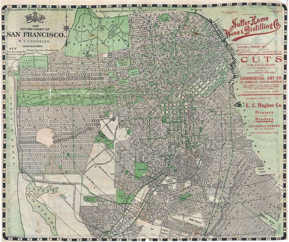
Map of City and County of San Francisco.
1906 (dated) 15.5 x 18.5 in (39.37 x 46.99 cm) 1 : 29000
1906 (dated) 15.5 x 18.5 in (39.37 x 46.99 cm) 1 : 29000
Description
This is an appealing 1906 pocket map of San Francisco, California, by H. A. Candrian. Issued in the same year as the 1906 San Francisco earthquake which destroyed a majority of the city, this map covers from Presidio Park as far south as McLaren Park and the Laguna de la Merced. The map names all major and minor streets as well as trolley lines, lakes, golf courses, piers, municipal buildings, colleges, street cars, railways, fire districts, and military installations. Parks and public areas are highlighted in green. Title and legend in the upper right quadrant.
This map also includes advertisements promoting various businesses of the time, including the Sutter Home Wine and Distilling Company, which still exists today. This map was drawn by D. W. Candrian and copyrighted and issued by H.A. Candrian in 1906.
This map also includes advertisements promoting various businesses of the time, including the Sutter Home Wine and Distilling Company, which still exists today. This map was drawn by D. W. Candrian and copyrighted and issued by H.A. Candrian in 1906.
Cartographer
Hermon Anton Candrian (March 28, 1852 - November 28, 1928), commonly publishing as H. A. Candrian, was a Swiss-American map publisher active in San Francisco in the first half of the 20th Century. Candrian was born in Bonaduz, Graubünden, Switzerland. It is unclear when he emigrated to the Untied States, but he working as an insurance agent in Seattle around 1900 and by 1905 had relocated to San Francisco. From at least 1906, his wife, Bertha Wilhemina Candrian (née Harry; 1862 - 1944), drafted many of his maps. Candrian’s works focus heavily and tourist and railway guides to the city of San Francisco and the general Bay Area. More by this mapmaker...
Condition
Good. Some wear with tears along original fold lines, repaired. Foxing and stains at places. Professionally flattened and backed with archival tissue. Part of map missing between in Sunset District and over Lake Merced. Map of Oakland on verso covered with backing tissue.
References
OCLC: 80380557.