1635 Willem Blaeu / Anders Bure Map of Scandinavia
Scandinavia-blaeu-1635$1,250.00


Title
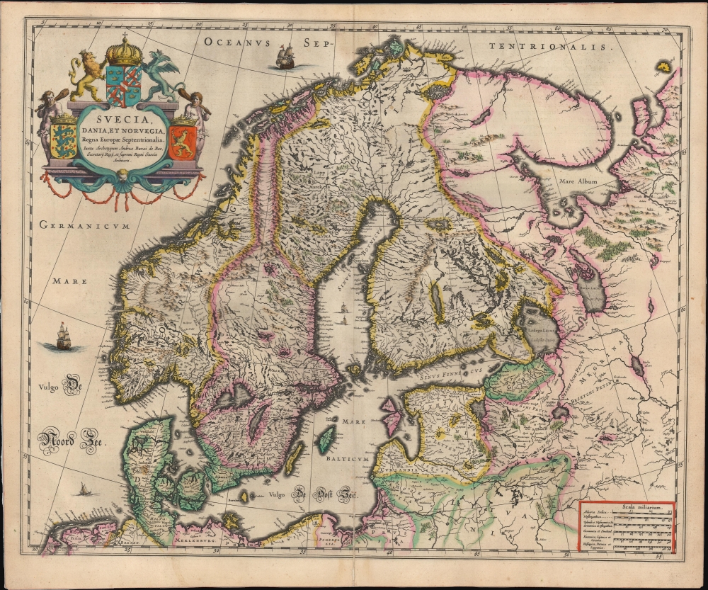
Suecia, Dania, et Norvegia Regna Europae Septentrionalia, iuxta Archetypum Andreae Burei de Boo, Secretarii Regij, et supremi Regni Sueciae Architecti.
1635 (undated) 16.75 x 20.75 in (42.545 x 52.705 cm) 1 : 4500000
1635 (undated) 16.75 x 20.75 in (42.545 x 52.705 cm) 1 : 4500000
Description
This is a 1635 edition of Willem Blaeu's map of Scandinavia at the height of the Thirty Years' War. It is based on Anders Bure's 1626 mapping of the region, which swiftly became the dominant mapping of the northern parts of Europe and was not replaced as an authority for more than a century. On the strength of his seminal map and its long tenure as the state-of-the-art map of the northern regions of Europe, Bure is hailed as the Father of Swedish Cartography. The scope of the map includes Denmark, Norway, the greater Swedish Empire, the Baltic coasts of Germany, Poland and Livonia, and the Russian Empire.
A Closer Look
The map spans from Frisia, the northern part of the Netherlands in the southwest, to the opening of the White Sea. Thus, the map embraces not only Scandinavia, Denmark, Norway, Sweden, and Finland but also the Baltic Sea, the northern parts of Lithuania, Livonia, Estonia, and Russia's northwestern frontiers. It is beautifully engraved and decorated with sailing ships. Forests and mountains are shown pictorially.Historical Context
In 1635, when this map was printed, Scandinavia was deeply entangled in the Thirty Years' War (1618 - 1648), a massive European conflict with wide-reaching repercussions. Sweden, under the leadership of King Gustavus Adolphus (until his death in 1632), had emerged as a major Protestant power in Europe, intervening in the war to support Protestant states and counter the Catholic Habsburgs. By 1635, Sweden had signed the Treaty of Stettin (1630), securing its influence in northern Germany, and was at the height of its military and political dominance under Chancellor Axel Oxenstierna, who continued Sweden’s participation in the war after Gustavus Adolphus’s death. Denmark, on the other hand, had suffered a significant setback earlier in the conflict after King Christian IV’s defeat in the Danish phase of the Thirty Years' War (1625 - 1629). The Treaty of Lübeck (1629) forced Denmark out of the war and limited its ambitions in northern Germany. At this time, Scandinavia was characterized by the contrasting fortunes of Sweden’s rising power and Denmark’s diminished influence, as both kingdoms vied for control of the Baltic region and dominance in northern Europe. Norway, united with Denmark in a personal union, played a more passive role during this period.Publication History and Census
This map was engraved in 1634 for inclusion in Blaeu's Atlas, first appearing in the 1634 German text edition. The present example corresponds to the 1635 French-text edition of the atlas, the earliest in that language. We see perhaps nineteen examples of the separate map in institutional collections.CartographerS
Willem Janszoon Blaeu (1571 - October 18, 1638), also known as Guillaume Blaeu and Guiljelmus Janssonius Caesius, was a Dutch cartographer, globemaker, and astronomer active in Amsterdam during the late 16th and early 17th centuries. Blaeu was born 'Willem Janszoon' in Alkmaar, North Holland to a prosperous herring packing and trading family of Dutch Reformist faith. As a young man, he was sent to Amsterdam to apprentice in the family business, but he found the herring trade dull and instead worked for his cousin 'Hooft' as a carpenter and clerk. In 1595, he traveled to the small Swedish island of Hven to study astronomy under the Danish Enlightenment polymath Tycho Brahe. For six months he studied astronomy, cartography, instrument making, globe making, and geodesy. He returned to Alkmaar in 1596 to marry and for the birth of his first son, Johannes (Joan) Blaeu (1596 – 1673). Shortly thereafter, in 1598 or 1599, he relocated his family to Amsterdam where he founded the a firm as globe and instrument makers. Many of his earliest imprints, from roughly form 1599 - 1633, bear the imprint 'Guiljelmus Janssonius Caesius' or simply 'G: Jansonius'. In 1613, Johannes Janssonius, also a mapmaker, married Elizabeth Hondius, the daughter of Willem's primary competitor Jodocus Hondius the Elder, and moved to the same neighborhood. This led to considerable confusion and may have spurred Willam Janszoon to adopt the 'Blaeu' patronym. All maps after 1633 bear the Guiljelmus Blaeu imprint. Around this time, he also began issuing separate issue nautical charts and wall maps – which as we see from Vermeer's paintings were popular with Dutch merchants as decorative items – and invented the Dutch Printing Press. As a non-Calvinist Blaeu was a persona non grata to the ruling elite and so he partnered with Hessel Gerritsz to develop his business. In 1619, Blaeu arranged for Gerritsz to be appointed official cartographer to the VOC, an extremely lucrative position that that, in the slightly more liberal environment of the 1630s, he managed to see passed to his eldest son, Johannes. In 1633, he was also appointed official cartographer of the Dutch Republic. Blaeu's most significant work is his 1635 publication of the Theatrum orbis terrarum, sive, Atlas Novus, one of the greatest atlases of all time. He died three years later, in 1638, passing the Blaeu firm on to his two sons, Cornelius (1616 - 1648) and Johannes Blaeu (September 23, 1596 - December 21, 1673). Under his sons, the firm continued to prosper until the 1672 Great Fire of Amsterdam destroyed their offices and most of their printing plates. Willem's most enduring legacy was most likely the VOC contract, which ultimately passed to Johannes' son, Johannes II, who held the position until 1617. As a hobbyist astronomer, Blaeu discovered the star now known as P. Cygni. More by this mapmaker...
Anders Bure (August 14, 1571 - February 4, 1646) was a Swedish mathematician and cartographer. He is considered the father of Swedish cartography. He was the son of the parish priest Engelbertus Laurentii and Elisabeth Andersdotter Burea, descendant of the long-established Bureätten family. His immediate family included diplomats and government officials. His education is obscure, though he is mentioned as an office clerk in 1602. His duties in the following years involved recording royal genealogical and historical works, involving him in the highest echelons of Swedish society. He also participated in diplomatic assignments, including missions to both Russia and Finland. His cartographic contributions improved the mapping both of the northern parts of Sweden, and the kingdom as a whole. His six-sheet 1626 Orbis Arctoi represented the first real improvement to the mapping of the northern parts of Europe since the Olaus Magnus map of the previous century: this map would provide the basis for virtually every European map of Scandinavia to follow in the 17th century. In addition to these achievements, he was the first person recorded to use the decimal system in Sweden. Learn More...
Source
Blaeu, W., Théâtre du Monde ou Nouvel Atlas, (Amsterdam: Blaeu) 1635.
The classic Dutch atlas, whose publication ushered in the Dutch golden age of cartography. Willem Jansz Blaeu had been, since 1604, producing engraved maps for sale; these were separate issues (and all consequently extremely rare) until the publishing of Blaeu's Appendix in 1630 and 1631, which also included a number of maps purchased from the widow of Jodocus Hondius, (for example his famous iteration of John Smith's map of Virginia.) In 1634, he announced his intention to produce a new world atlas in two volumes, entitled Theatrum Orbis Terrarum, sive Atlas Novus (Théâtre du Monde ou Nouvel Atlas) (in an effort to invoke the successful work of the same title produced by Ortelius the previous century, while reinforcing the notion of it being a new work.) This work was published first in German in 1634, followed by Latin, Dutch and French editions in 1635. Blaeu's maps have always been noted for the quality of their paper, engraving and fine coloring, and this was the intent from the very start. The 1634 announcement of the upcoming work described it: 'All editions on very fine paper, completely renewed with newly engraved copperplates and new, comprehensive descriptions.' (van der Krogt, p,43) Many of the most beautiful and desirable maps available to the modern collector were printed and bound in Blaeu's atlases. Willem's son, Joan, would go on to add further volumes to the Atlas Novus, concurrently printing new editions of the first two volumes with additional maps, in effect making these new editions an entirely new book. Under Joan there would be nine Latin editions, twelve French, at least seven Dutch, and two German. This exceedingly successful work would be the mainstay of the Blaeu firm until 1661, at which point the work was supplanted by Joan Blaeu's masterwork Atlas Maior in 1662.
Condition
Very good. Mended centerfold split at bottom. Else a strong example with superb original color.
References
OCLC 1118153525. Rumsey 10017.079 (1665).