Digital Image: 1535 Fries / Clavus Map of Scandinavia - Medieval Mapping of the North
Scandinavia-fries-1522_d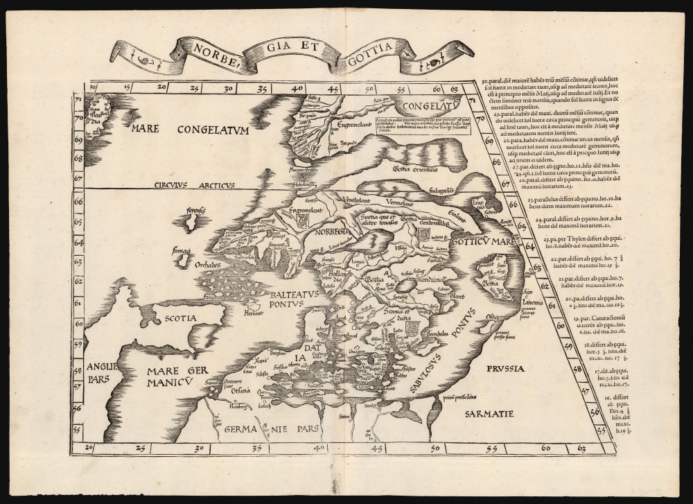

Title
Norbegia et Gottia.
1522 (undated) 13.25 x 17.75 in (33.655 x 45.085 cm) 1 : 6200000
1522 (undated) 13.25 x 17.75 in (33.655 x 45.085 cm) 1 : 6200000
Description
FOR THE ORIGINAL ANTIQUE MAP, WITH HISTORICAL ANALYSIS, CLICK HERE.
Digital Map Information
Geographicus maintains an archive of high-resolution rare map scans. We scan our maps at 300 DPI or higher, with newer images being 600 DPI, (either TIFF or JPEG, depending on when the scan was done) which is most cases in suitable for enlargement and printing.
Delivery
Once you purchase our digital scan service, you will receive a download link via email - usually within seconds. Digital orders are delivered as ZIP files, an industry standard file compression protocol that any computer should be able to unpack. Some of our files are very large, and can take some time to download. Most files are saved into your computer's 'Downloads' folder. All delivery is electronic. No physical product is shipped.
Credit and Scope of Use
You can use your digial image any way you want! Our digital images are unrestricted by copyright and can be used, modified, and published freely. The textual description that accompanies the original antique map is not included in the sale of digital images and remains protected by copyright. That said, we put significant care and effort into scanning and editing these maps, and we’d appreciate a credit when possible. Should you wish to credit us, please use the following credit line:
Courtesy of Geographicus Rare Antique Maps (http://www.geographicus.com).
How Large Can I Print?
In general, at 300 DPI, you should at least be able to double the size of the actual image, more so with our 600 DPI images. So, if the original was 10 x 12 inches, you can print at 20 x 24 inches, without quality loss. If your display requirements can accommodate some loss in image quality, you can make it even larger. That being said, no quality of scan will allow you to blow up at 10 x 12 inch map to wall size without significant quality loss. For more information, it is best consult a printer or reprographics specialist.
Refunds
If the high resolution image you ordered is unavailable, we will fully refund your purchase. Otherwise, digital images scans are a service, not a tangible product, and cannot be returned or refunded once the download link is used.
Cartographer S
Lorenz Fries (c. 1490 – 1531) was a German cartographer, cosmographer, astrologer, and physician based in Strasbourg. Little is known of Fries' early life. He may have studied in Padua, Piacenza, Montpellier and Vienna, but strong evidence of this is unfortunately lacking. The first recorded mention of Fries appeared on a 1513 Nuremberg broadside. Fries settled in Strasbourg in March 1519, where he developed a relationship with the St. Die scholars, including Walter Lud, Martin Ringmann and Martin Waldseemüller. There he also befriended the printer and publisher Johann Grüninger. Although his primary profession was as a doctor, from roughly 1520 to 1525 he worked closely with Grüninger as the geographic editor of various maps and atlases based upon the work of Martin Waldseemüller. Although his role is unclear, his first map seems to have been a 1520 reissue of Waldseemüller's world map of 1507. Around this time he also began working on Grüninger's reissue of Waldseemüller's 1513 edition of Ptolemy, Geographie Opus Novissima. That edition included three new maps by Fries based upon the Waldseemüller world map of 1507 – two of these, his maps of East Asia and Southeast Asia are quite significant as the first specific maps of these regions issued by a European publisher. In 1525 Fries decided to leave Strasbourg and surrendered his citizenship, relocating to Trier. In 1528 he moved to Basel. Afterwards he relocated to Metz where he most likely died. In addition to his cartographic work, Fries published tracts on medicine, religion, and astrology. More by this mapmaker...
Claudius Clavus (Danish: Claudius Claussøn), (September 14, 1388 - ?) was a Danish geographer, remembered for having produced the first mapping of Scandinavia, Iceland and Greenland: his medieval mapping of the north remained the standard for the mapping of Iceland until well into the 16th century. He is thought to have been born on the island of Funen, in the village of Salling. At the age of 25 he began to travel in Europe - he is thought to have traveled as to the northernmost parts of Norway - but he arrived in Rome in around 1423. There he befriended well placed papal scholars who were working to update Ptolemy's geographical ideas; he contributed the first realistic description of the north parts of Europe, particularly those beyond 63° North, which had been the northern limit of Ptolemy's Oikoumene. Clavus included the first accurate placement of Iceland, and what was probably the first instance of Greenland to appear on a map. (He included as well a number of placenames, which he invented - or rather, repurposed - from the lyrics of songs. Most of his own work has been lost. Copies of his map of the north were made by Donnus Nicolaus Germanus, and through him Clavus' map became part of canon. He also drew up a manuscript copy of the Ptolmaic maps, 27 maps of which survive. Learn More...
Source
Ptolemy, C., Geographicae Enarrationis..., (Lyons: Servetus) 1535.
References
Ginsberg, W., Scandia: Important Early Maps of the Northern Regions and Maps and Charts of Norway, #7 (1513 Waldseemuller). Rumsey 10891.101 (1525).