This item has been sold, but you can get on the Waitlist to be notified if another example becomes available.
1959 Army Map Service Map of Seoul, South Korea
SeoulKorea-ams-1959$250.00


Title
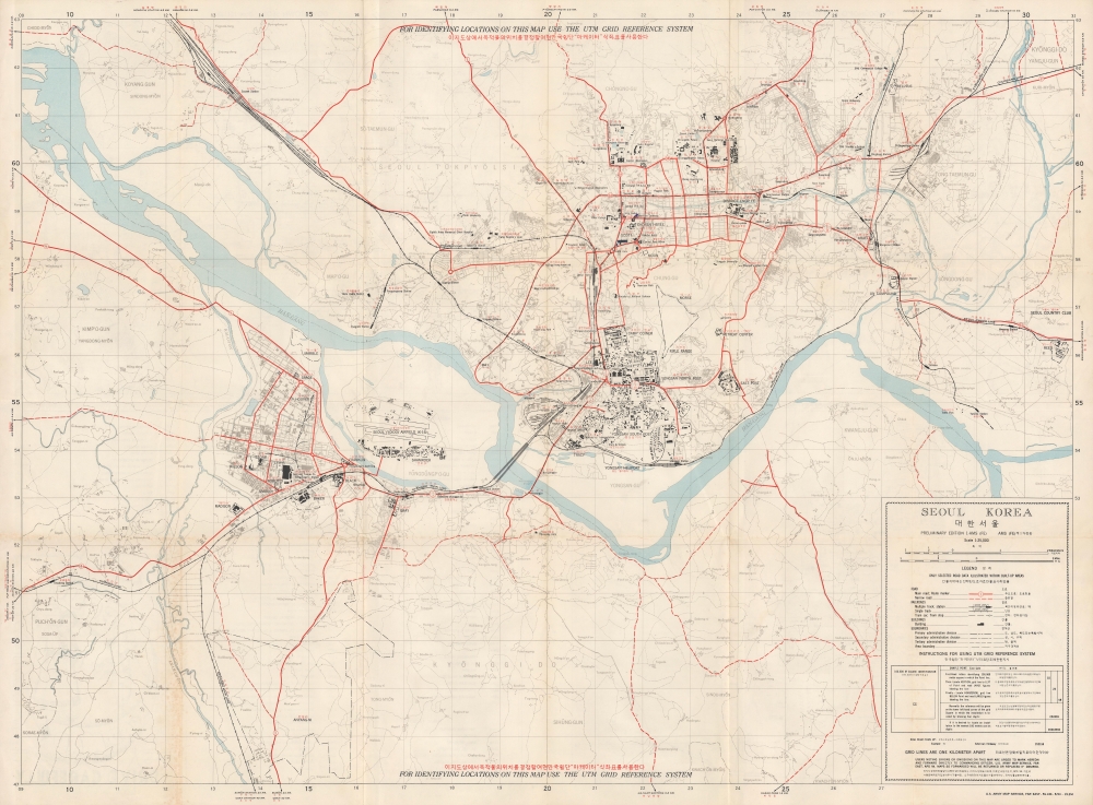
Seoul Korea.
1959 (dated) 26.5 x 37.75 in (67.31 x 95.885 cm) 1 : 25000
1959 (dated) 26.5 x 37.75 in (67.31 x 95.885 cm) 1 : 25000
Description
This is a 1959 U.S. Army Map Service Far East city map of Seoul, South Korea. Published 6 years after the Korean War (1950 - 1953), this map highlights the extensive and ongoing post-war U.S. military presence in Seoul. In so doing, it underscores the importance of the United States-South Korean Mutual Defense Treaty to the security of South Korea.
A Closer Look
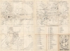
Entirely bilingual, locations throughout the city are labeled in English (black) and Korean (red). City parks, universities, hotels, hospitals, train stations, shrines, palaces, and the central post office are identified alongside American military installations. The nearest towns along road and rail lines are labeled in the margin. The whole is surrounded by a numerical grid reference system that can be used to identify locations of specific sites throughout the city.Verso Content
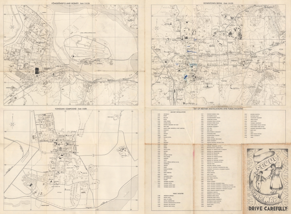
Three maps are printed on the verso. The first (on the top left) details the Yeungdeungpo neighborhood of Seoul. This neighborhood includes the Seoul Airport and nearly a dozen American military installations. The second focuses on downtown Seoul, naming important locations, including the American Embassy and the Police Bureau (both highlighted in blue ink by the previous owner). Other identified locations include the YMCA, the Red Cross Hospital, and numerous Korean government buildings. On the lower right is a list of military installations and public buildings, along with each location's grid coordinates.Yongsan Garrison
The final map, in the lower left, depicts Yongsan Garrison, a massive U.S. military installation in the center of Seoul. The garrison was originally set up by the Japanese in 1910 during the occupation of Korea. After World War II (1939 - 1945), the American military took over the base. The Americans remained at Yongsan (which covers 630 acres) until 2023, when the move to Camp Humphreys (even larger than the Yongsan Garrison) was finally complete. The Yongsan Garrison will be returned to the South Korean government, which has not yet decided what will replace the garrison. The National Museum of Korea moved onto returned land and opened in 2005.Publication History and Census
This map was created and published by the Army Map Service, Far East in May 1959. We note 4 examples cataloged in OCLC, which are part of the collections at the Library of Congress, the University of Texas, the University of California Berkeley, and the University of Cambridge.Cartographer
The Army Map Service (AMS) (1941 - 1968) was the military cartographic agency of the U.S. Department of Defense and part of the U.S. Army Corps of Engineers. The AMS compiled, published, and distributed military topographical maps and other related materials for use by the U.S. Armed Forces. They also prepared maps for space exploration, intelligence reports, and the establishment of world geodetic control networks. Formed during World War II, by the end of the war the Army Map Service had prepared 40,000 maps. 3,000 different maps were created for the Normandy invasion alone. The AMS was instrumental in the Korean War and the Vietnam War, and during all three of these conflicts distributed tens of millions of maps to U.S. servicemen. On September 1, 1968, the AMS was resdesignated the U.S. Army Topographic Command, and continued under this name as an independent organization until January 1, 1972 when it was merged with the new Defense Mapping Agency and renamed the DMA Topographic Center. The Defense Mapping Agency was added to the National Imagery and Mapping Agency on October 1, 1996, which was redesigned the National Geospatial-Intelligence Agency in 2003. More by this mapmaker...
Condition
Very good. Light wear along original fold lines. Maps of downtown Seoul, Yeungdeungpo, and the Yongsan Compound on verso. List of military installations and public facilities on verso. Some toning. Manuscript blue ink on recto and verso.
References
OCLC 444602494.