1858 Milne / Becker Map of Shanghai, China
Shanghai-becker-1858$850.00

Title
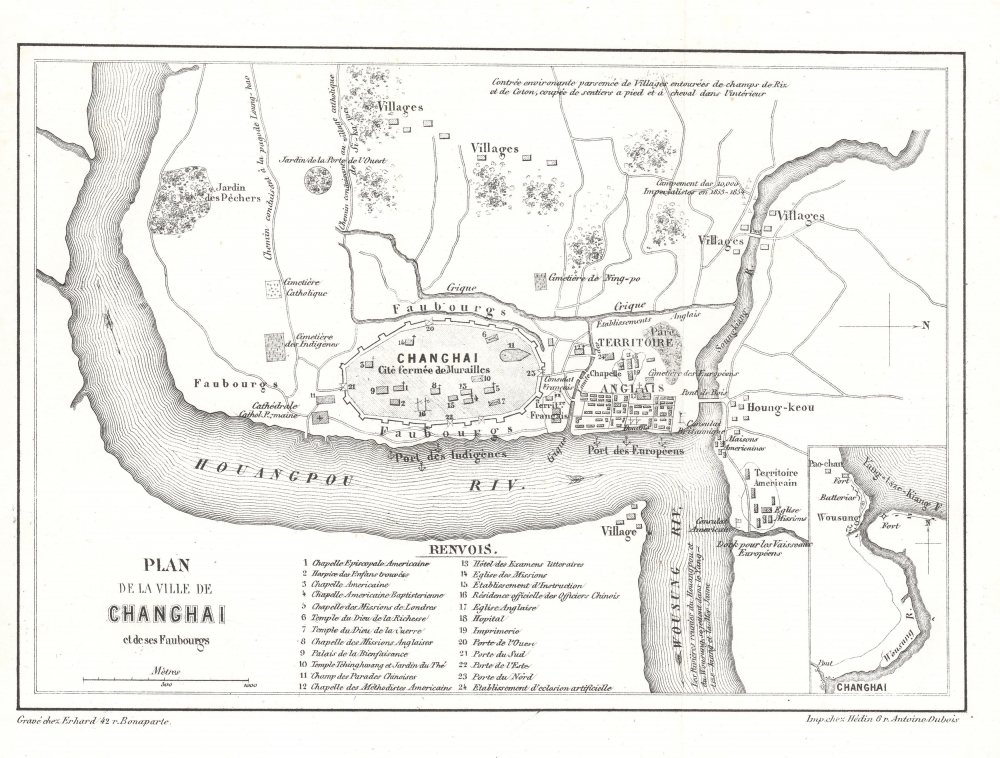
Plan de la Ville de Changhai et de ses Faubourgs.
1858 (undated) 6.25 x 8.25 in (15.875 x 20.955 cm) 1 : 28000
1858 (undated) 6.25 x 8.25 in (15.875 x 20.955 cm) 1 : 28000
Description
This 1858 map of Shanghai by W. S. Milne and Erhard illustrates the early days of the Treaty Port Era (1842 - 1943). Cartographically, it is one of the earliest Western representations of Shanghai, based on the L. M. Becker map of 1853, itself drawn and published in the 1857 first English edition of Milne's Life In China. This example is the 1858 French edition. Although printed in 1858, the cartography dates to the late 1840s or early 1850s, when Milne visited Shanghai, thus revealing the early stages of Concession development.
Given Milne's background as a missionary, special attention is paid to churches and mission houses. Chinese temples within the walled city are also noted. Paths at top lead to destinations further to the west, including the Longhua Pagoda and the Catholic compound at Xujiahui (Si-ka-wei). At right is Hongkou (Hung-kow), where Americans predominated and where, in later decades, thousands of Japanese would reside. The village at the bottom, across the Huangpu (Hwangpoo) from the main part of the city, is Lujiazui, the most heavily developed portion of Pudong, now dominated by skyscrapers.
However, the wider question of the Taiping, based in nearby Nanjing, had not disappeared. In 1860, Taiping forces attacked and briefly occupied the walled city of Shanghai. Over the next two years, the two opposing sides fought throughout the surrounding region, with Qing forces, backed by foreign powers and the 'Ever Victorious Army,' a foreign-led group of mercenaries and local recruits, eventually staving off the threat to Shanghai. Still, it was not until 1864 that the Qing recaptured Nanjing, the penultimate battle of the war with the Taiping.
A Closer Look
Oriented towards the west, the map takes in Shanghai's walled 'Chinese city,' the nearby foreign settlements, and the city's hinterland. The map marks out distinct English, French, and American Territories, thus predating the merger of the British and American Concessions - the French Concession remained separate. This map also makes clear that the territory of the foreign concessions, initially not intended to be distinct from Chinese territory, evolved from their bases along the riverfront (Bund); in time, the foreign concessions would extend well beyond the scope of this map and develop administrative bodies, police forces, and courts.Given Milne's background as a missionary, special attention is paid to churches and mission houses. Chinese temples within the walled city are also noted. Paths at top lead to destinations further to the west, including the Longhua Pagoda and the Catholic compound at Xujiahui (Si-ka-wei). At right is Hongkou (Hung-kow), where Americans predominated and where, in later decades, thousands of Japanese would reside. The village at the bottom, across the Huangpu (Hwangpoo) from the main part of the city, is Lujiazui, the most heavily developed portion of Pudong, now dominated by skyscrapers.
Small Swords Uprising
A note about the 'Campement des 10,000 Iemperialistes en 1853 - 1854' does not refer to foreign imperialists but to Qing imperial forces, sent to Shanghai to suppress the Small Swords Uprising, which had overtaken the walled city in September 1853 and aligned itself with the Taiping Heavenly Kingdom, another, much larger rebel force in southern China. The nascent foreign community was divided on the uprising; the French sided strongly with the Qing, even committing troops to aid the Qing forces besieging the walled city, while the British and Americans were more circumspect. Eventually, though, they came to tepidly support the Qing, who recaptured the walled city in February 1855.However, the wider question of the Taiping, based in nearby Nanjing, had not disappeared. In 1860, Taiping forces attacked and briefly occupied the walled city of Shanghai. Over the next two years, the two opposing sides fought throughout the surrounding region, with Qing forces, backed by foreign powers and the 'Ever Victorious Army,' a foreign-led group of mercenaries and local recruits, eventually staving off the threat to Shanghai. Still, it was not until 1864 that the Qing recaptured Nanjing, the penultimate battle of the war with the Taiping.
Publication History and Census
The map can trace its origins to L.M. Becker's map of 1853-1857. Little is known of Becker, but he must have been an associate of Milne in China, possibly another missionary. The map was originally published in 1857 in English. The present example is the 1858 first French edition (Hachette), noteworthy for the unusual spelling of 'Changhai' in the title - in all other examples we've seen, the spelling follows the more conventional 'Shanghai.' It is a fresh engraving by Charles Erhard, printed in Paris by Chez Hédin Gr. Antoine Dubois. The map appears on the market in its various editions from time to time and is well represented in institutions, but this is the only known example of this 'Changhai' state.Cartographer
Georges Erhard Schièble (1823 – November 23, 1880) was a German printer active in Paris during the middle to late 19th century. Erhard was born in Forchheim, Baden-Württemberg, and relocated to Paris in his 16th year, where he apprenticed under his cousin, an engraver and mapmaker. In 1852, after 6 years with the Royal Printing Office, he started his own business. Around this time, he also became a naturalized French citizen. From his offices on Rue Bonaparte, he produced several important maps, and a detailed topography of Gaul for Napoleon III's History of Julius Caesar. In 1865 he took on larger offices expanding his operations to include a lithographic press. He was among the first to introduce printed color maps and pioneered photo-reduction, including the process known as Erhard reproduction. After Erhard's death in 1880, the firm was taken over by his sons and run under the imprint of 'Erhard Frères' until 1911. More by this mapmaker...
Source
Milne, W. C., La Vie Réelle en Chine, (Paris: Hachette) 1858.
Condition
Fine.