This item has been sold, but you can get on the Waitlist to be notified if another example becomes available, or purchase a digital scan.

1849 Stansbury Map w/ Steamship Lines btwn Shanghai and San Francisco

ShanghaiSanFrancisco-stansbury-1849
$275.00
Map indicating the proposed Course of the Steam Navigation between San Francisco and Shanghae. - Main View
Processing...

1849 Stansbury Map w/ Steamship Lines btwn Shanghai and San Francisco

ShanghaiSanFrancisco-stansbury-1849

Map made at the height of the Shanghaiing epidemic in San Francisco and Astoria.

Title


Map indicating the proposed Course of the Steam Navigation between San Francisco and Shanghae.
  1849 (undated)     19 x 23 in (48.26 x 58.42 cm)     1 : 33000000

Description


This is an unusual c. 1850 China Trade map illustrating the steam navigation routes between San Francisco, California, Shanghai, China, and Sydney, Australia. The map coves all of the Pacific Ocean from New Zealand to the Aleutian Islands and from Shanghai to the Panama. Seam routes are noted, among them several proposed routes between the fur trading settlement of Astoria and other destinations, including Shanghai and Hawaii.

Proposal for a Steamship Route

This map most likely follows an earlier map issued to accompany The Committee on Naval Affairs report submitted to the 30th Congress (House), 1st Session. The document explored the practically and value of establishing a permanent steamship route across the Pacific to Shanghai and Canton. The Gold Rush (1849) population explosion in California and the American west cost in general increased the need for a trans-pacific trade route. Until the construction of the Pacific Railroad, it was far more practical to look westward for trade than eastward across the rugged interior of the United States.


The Golden Age of Shanghaiing

This map was issued during the height of Pacific Shanghaiing, in fact, it was during this time and on this route that the term developed. Steamships plying the lucrative California – Shanghai were often short of sailors on America's west coast as many jumped ship to join the California Gold Rush. In desperate need of deck hands, ship captains turned to the criminal element who served as 'crimps,' typically drugging, abducting, and 'selling' their victims to the work the steamship lines. The problem was exceptionally prevalent between 1855 and 1880 in San Francisco and Astoria – both feature prominently on this map.

The map is ascribed to Arthur J. Stansbury, who probably issued it to accompany one of his articles on Congressional activity. The configuration of Texas suggests a post 1850 date and the congressional debate regarding the proposed steamship routes occurred in 1849, suggesting that this document was not part of the official report. It was engraved by A. Hoen and Company, a firm based in Baltimore who specialized in government printing. This map is extremely rare, with only one other example known at the Huntington Library.

CartographerS


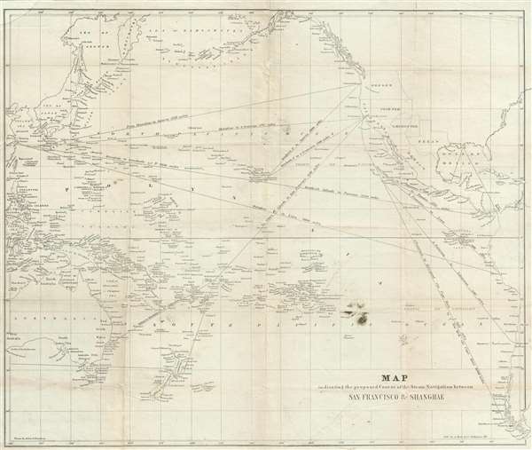
Arthur Joseph Stansbury (1781 – September 27, 1865) was an American Presbyterian minister and newspaperman active I the first half of the 20th century Stansbury was born at 42 broad Street, New York City. He studied at Columbia College, graduating in 1799. Shortly thereafter he seems to have become involved with his brother Abraham Stansbury in a bookselling, bookbinding, and stationary business based at No. 114 Water-street opposite the Old Coffee-house. Three years later in 1803 he married Susan Brown of Boston. Changing careers, he was licensed for the ministry in 1810 and worked as an itinerant preacher in New York and New Jersey. Around 1822, Stansbury again abruptly changed careers becoming a newspaper reporter. He eventually took work with the Washington D.C. National Intelligencer focusing on court debates and congressional activity. He was admired for his copious and detailed transcriptions court events. In addition to his reporting work, Stansbury was a noted artist, lithographer, and poet. He made a well-known portrait of John Quincy Adams on his deathbed which he sold commercially. He also wrote children's books. Little is known of his cartographic activity. He published a map of the northern part of the state of New York with Amos Lay in 1801 under the imprint of Brown and Stansbury (John Brown and A. J. Stansbury's brother Abraham Stansbury). More by this mapmaker...


August Hoen and Company (fl. c. 1840 - 1981) was a Baltimore based engraving and lithography firm active in the middle part of the 19th century. A. Hoen & Co. was originally founded by Edward Weber under the name 'E. Weber & Company.' Weber died in the early 1850s and his company was taken over by German immigrant August Hoen (18?? - 1886) and his brothers, Henry and Ernest Hoen. As general interest lithographers, the Hoen firm's corpus includes posters, cigar boxes, sheet music covers, and posters as well as maps. They are best known for their pioneering multi-color lithographic techniques. After the death of August Hoen, the business passed on to his son, Albert Hoen. Another son, Earnest A. Hoen, moved to Richmond, Virginia and opened a branch of the firm there where he was granted a charter to produce Civil War era Confederate Currency. Their contributions to the cartographic field are generally in association with engraving and printing work done for Jacob Monk and the U.S. Geological Survey. The Hoen family maintained an active interest in the firm for the next 100 years or so until it finally filed for bankruptcy in 1981. Learn More...

Source


King, T. Butler, The Committee on Naval Affairs have had under consideration the expediency of establishing a communication by steamers from the territory of the United States, on the Pacific Ocean, to Shanghae and Canton (Washington) 1848.    

Condition


Good. Backed on archival tissue. Upper left corner reinstated in manuscript. Wear on original fold lines and some slight infill at fold intersections. Even toning throughout.

References


OCLC 55705590. Huntington Library, 337858.