1890 Italian Map of Shan States, Northern Siam, and Laos
ShanStates-italian-1890$500.00

Title
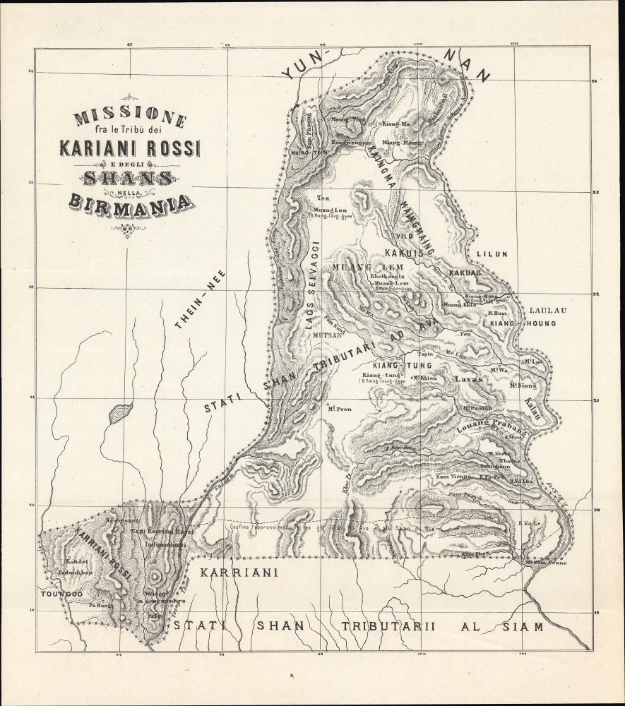
Missione fra le Tribù dei Kariani rossi e degli Shans nella Birmania.
1890 (undated) 12.25 x 11.25 in (31.115 x 28.575 cm)
1890 (undated) 12.25 x 11.25 in (31.115 x 28.575 cm)
Description
A curious c. 1890 Italian-language map of the Burmese Shan States and environs, stretching as far east as Luang Prabang. The title and some historical context strongly suggest that this map was prepared by Italian missionaries of the Pontifical Institute for Foreign Missions society in the years after the Third Anglo-Burmese War.
A Closer Look
Coverage ranges from the Sittang River to the Mekong River, coterminous with today's Shan State, along with portions of northern Thailand and Laos. The Salween River forms much of the western boundary of the Shan States at the left, while the Lancang River at the top serves as the border with Yunnan province of China. Mountains, rivers, settlements, and Indigenous groups are labeled throughout. The territory at the bottom-left, near Taungoo, is noted as being the realm of the Red Karens, or Karenni people. A line towards the bottom demarcates the 'Ava' Shans (using the term for the kingdom the Shans conquered in the 16th century) from those who were tributaries of Siam.P.I.M.E. Missionaries in the Shan States
This map contains no publication information. We have been unable to identify a source text, if any, but it most likely was produced by Italian missionaries of the Pontifical Institute for Foreign Missions. Italian P.I.M.E. missionaries, led by Eugenio Biffi, Rocco Tornatore, Tancredi Conti, and Sebastiano Carbone, arrived in this region in 1867 and were based at Taungoo. Focusing on the territory east of the Salween River, an area as large as their native Italy but little known to Westerners, they proselytized among the 'tribal' communities (Karen, Shan, etc.) distrusted by both the Burmans and British. Traveling into rugged mountain territory, the missionaries met with limited success but did gain important geographic, linguistic, and cultural knowledge.The Shan States (1885 - 1948)
Occupying a large portion of this map, the Shan States were a collection of kingdoms in British Burma and northern Siam. These states had been independent kingdoms for hundreds of years, each with its own agreement to pay tribute to a certain country for protection, either Burma or China. When the British invaded in 1885 (the Third Anglo-Burmese War), this upset the delicate balance and led to years of fighting and insurgency. To this day, the Shan States are in open rebellion against the Myanmar central government.Publication History and Census
As mentioned above, this map contains no publication information but was most likely produced by Italian P.I.M.E. missionaries in the late 19th century. We have been unable to identify a source text, if any (the mention of 'Shan States' suggests a date after 1885). We do not find this map in any institutional holdings or historical sales on the market.Condition
Very good. Light wear along original fold lines.