Digital Image: 1900 McCarthy Map of Siam, Laos, Cochinchina, Cambodia and the Malay Peninsula
Siam-mccarthy-1900_d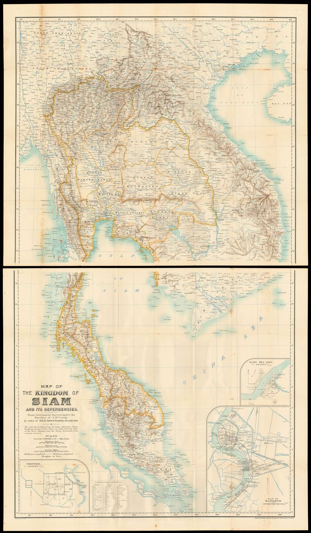

Title
Map of the kingdom of Siam and its dependencies
1900 (undated) 52.25 x 29 in (132.715 x 73.66 cm) 1 : 2000000
1900 (undated) 52.25 x 29 in (132.715 x 73.66 cm) 1 : 2000000
Description
FOR THE ORIGINAL ANTIQUE MAP, WITH HISTORICAL ANALYSIS, CLICK HERE.
Digital Map Information
Geographicus maintains an archive of high-resolution rare map scans. We scan our maps at 300 DPI or higher, with newer images being 600 DPI, (either TIFF or JPEG, depending on when the scan was done) which is most cases in suitable for enlargement and printing.
Delivery
Once you purchase our digital scan service, you will receive a download link via email - usually within seconds. Digital orders are delivered as ZIP files, an industry standard file compression protocol that any computer should be able to unpack. Some of our files are very large, and can take some time to download. Most files are saved into your computer's 'Downloads' folder. All delivery is electronic. No physical product is shipped.
Credit and Scope of Use
You can use your digial image any way you want! Our digital images are unrestricted by copyright and can be used, modified, and published freely. The textual description that accompanies the original antique map is not included in the sale of digital images and remains protected by copyright. That said, we put significant care and effort into scanning and editing these maps, and we’d appreciate a credit when possible. Should you wish to credit us, please use the following credit line:
Courtesy of Geographicus Rare Antique Maps (http://www.geographicus.com).
How Large Can I Print?
In general, at 300 DPI, you should at least be able to double the size of the actual image, more so with our 600 DPI images. So, if the original was 10 x 12 inches, you can print at 20 x 24 inches, without quality loss. If your display requirements can accommodate some loss in image quality, you can make it even larger. That being said, no quality of scan will allow you to blow up at 10 x 12 inch map to wall size without significant quality loss. For more information, it is best consult a printer or reprographics specialist.
Refunds
If the high resolution image you ordered is unavailable, we will fully refund your purchase. Otherwise, digital images scans are a service, not a tangible product, and cannot be returned or refunded once the download link is used.
Cartographer S
James Fitzroy McCarthy (1853 - September 23, 1919) was an Irish surveyor and cartographer who was instrumental in the setting of Thailand’s borders in the late 19th century. By 1873 he was a member of the Survey of India, and his duties with the survey led him through Burma to Siam, where he would undertake what would prove to be his most enduring work. He produced the first scientific maps of Siam, which became the documents of reference during that period’s colonial conflict between the British and French over Southeast Asia. In 1885 he became the first Director-General of Siam’s Royal Survey Department, later the Royal Thai Survey Department, which was established in 1885. More by this mapmaker...
Auguste Jean-Marie Pavie (May 31, 1847 - June 7 1925) was a French civil Servan, explorer and diplomat active in Southeast Asia. As resident minister in Bankok, he was instrumental in French successes of 'gunboat diplomacy' in the Franco-Siamese war, which established French authority in the Mekong river valley and resulted in the French Protectorate over Laos. (He would become Minister of the colony , and eventually the first Governor-General of Laos.) Over the course of the 1880s and 1890s, Pavie undertook four survey missions embracing over 250,000 square miles in the highlands North and East of the Mekong, traveling on foot, by elephant and by raft with a team of as many as 40 assistants. The four Missions covered 1) Cambodia and Southern Siam; 2) Northeastern Laos and the exploration of the Black river as far as Hanoi; 3) the Mekong river from Saigon to Luang Prabang; and 4),from 1894 to 1895, the Laotian borderings with China and Burma. In addition to his governmental and cartographic work, Pavie was active in the 1889 establishment of and institution for the education of future colonial administrators, the École coloniale Learn More...
Alexander Keith Johnston (December 28, 1804 - July 9, 1871) was a Scottish cartographer and map publisher active in the middle portion of the 19th century. Johnson was born at Kirkhill, near Edinburgh, Scotland. He studied at the University of Edinburgh where he apprenticed as an engraver. Around 1826, in partnership with his brother William, he founded a cartographic printing and engraving firm with the imprint "W. and A. K. Johnston." Johnston made a name for himself in educational geography, publishing numerous maps for use in schools. His brother, William Johnston, eventually left the firm to pursue a career in politics, eventually becoming the Lord Provost of Edinburgh. Alexander's son, who would bear the same name, became a geographer and explorer, suffering an untimely death on the Royal Geographical Society's 1879 expedition to Lake Nyasa. Learn More...
Henry Sharbau, (fl. 1870-1906) was a lithographer active in London and Edinburgh. While nothing is known of his early training, it is likely that his early years were spent with the navy: his earliest known works of the 1870s were on charts produced by the Hydrographic Department. The 1880s saw the beginning of a long association with the Royal Geographic Society, and then with the mapmaking firm of W. and A.K. Johnston. Over a hundred works appear in OCLC with Sharbau’s imprint. Interestingly, the British Naval Lists reveal a Frederic Henry Sharbau (1867-1963!!!) working as a cartographer and draughtsman starting about 1907 and lasting into the 20s. Perhaps this Methuselah is a son? Learn More...
Source
McCarthy, J. F. Surveying and exploring in Siam. (London, J. Murray) 1900.
References
OCLC 63529781. Meinheit, Harold: 'The Man Who Mapped Siam: Kames McCarthy ands the Royal Survey Department' The Portolan Issue 105, Fall 2019 pp 9-26.