This copy is copyright protected.
Copyright © 2025 Geographicus Rare Antique Maps
Digital Image: 1779 Orcel / Schmettau Folding Wall Map of Sicily, Italy
Sicily-orcel-1779_d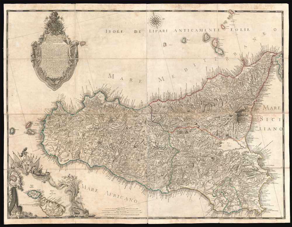

FOR THE ORIGINAL ANTIQUE MAP, WITH HISTORICAL ANALYSIS, CLICK HERE.
Digital Map Information
Geographicus maintains an archive of high-resolution rare map scans. We scan our maps at 300 DPI or higher, with newer images being 600 DPI, (either TIFF or JPEG, depending on when the scan was done) which is most cases in suitable for enlargement and printing.
Delivery
Once you purchase our digital scan service, you will receive a download link via email - usually within seconds. Digital orders are delivered as ZIP files, an industry standard file compression protocol that any computer should be able to unpack. Some of our files are very large, and can take some time to download. Most files are saved into your computer's 'Downloads' folder. All delivery is electronic. No physical product is shipped.
Credit and Scope of Use
You can use your digial image any way you want! Our digital images are unrestricted by copyright and can be used, modified, and published freely. The textual description that accompanies the original antique map is not included in the sale of digital images and remains protected by copyright. That said, we put significant care and effort into scanning and editing these maps, and we’d appreciate a credit when possible. Should you wish to credit us, please use the following credit line:
Courtesy of Geographicus Rare Antique Maps (http://www.geographicus.com).
How Large Can I Print?
In general, at 300 DPI, you should at least be able to double the size of the actual image, more so with our 600 DPI images. So, if the original was 10 x 12 inches, you can print at 20 x 24 inches, without quality loss. If your display requirements can accommodate some loss in image quality, you can make it even larger. That being said, no quality of scan will allow you to blow up at 10 x 12 inch map to wall size without significant quality loss. For more information, it is best consult a printer or reprographics specialist.
Refunds
If the high resolution image you ordered is unavailable, we will fully refund your purchase. Otherwise, digital images scans are a service, not a tangible product, and cannot be returned or refunded once the download link is used.
Gian Giuseppe Orcel (fl. c. 1775 - 1793) was a French bookseller and publisher based in Palermo, Sicily, during the second half of the 18th century. Orcel opened a bookshop in Palermo, operating in partnership the brothers Martinon, one of who had a shop in Messina. Orcel and a few others were solely responsible for selling and publishing foreign language titles in Sicily and thus keeping the lines of intellectual exchange open. He greatest cartographic achievement was the publication of a massive wall map of Italy based upon the original 1720 manuscript of the Austrian military officer and surveyor Samuel Graf von Schmettau, his expanded and revised map, on a much larger scale the Schmettau's 1723 publication, was the finest and largest map of Sicily yet published. More by this mapmaker...
Samuel Graf von Schmettau (March 24, 1684 - August 18, 1751) was a Prussian Field Marshal and cartographer active in the first half of the 18th century. Schmettau was born in London at the Royal Prussian Amtskammerrat the Embassy of influential Hugueont stock. He joined the military at just 15, serving under various flags for various commanding officers, most of whom were his relatives. He saw battle on multiple occasions and rose quickly through the ranks, being made major in 1707 and lieutenant colonel in 1708, and field marshal lieutenant in 1733. In 1741 he was made Imperial Field Marshal, but transferred to the Prussian Army to become instead Prussian Field Marshal. In 1842 he received the Order of the Black Eagle. He was an excellent self-educated cartographer, producing his first map, a detailed survey of Sicily issued in 1723. A plan of Berlin followed in 1748, and a plan of Ostfriesland in 1751. Learn More...
Garofalo Panormit (fl. c. 1750 - 1800) was an Italian engraver based in Palermo and Rome. Most of his extant work consist of ecclesiastical portraiture. In 1779 he did engrave one large map of Sicily in partnership with the French/Sicilian publisher Gian Giuseppe Orcel. Learn More...
Copyright © 2025 Geographicus Rare Antique Maps | Geographicus Rare Antique Maps
This copy is copyright protected.
Copyright © 2025 Geographicus Rare Antique Maps