This copy is copyright protected.
Copyright © 2025 Geographicus Rare Antique Maps
Digital Image: 1847 Emory Map of Battle of Embudo Pass, New Mexico during the Taos Revolt
SketchFeb15-usgovt-1847_d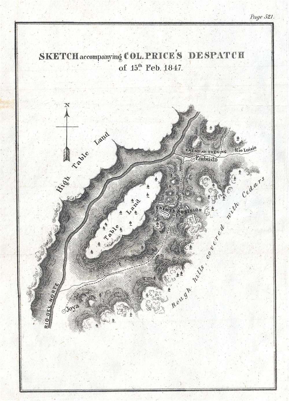

FOR THE ORIGINAL ANTIQUE MAP, WITH HISTORICAL ANALYSIS, CLICK HERE.
Digital Map Information
Geographicus maintains an archive of high-resolution rare map scans. We scan our maps at 300 DPI or higher, with newer images being 600 DPI, (either TIFF or JPEG, depending on when the scan was done) which is most cases in suitable for enlargement and printing.
Delivery
Once you purchase our digital scan service, you will receive a download link via email - usually within seconds. Digital orders are delivered as ZIP files, an industry standard file compression protocol that any computer should be able to unpack. Some of our files are very large, and can take some time to download. Most files are saved into your computer's 'Downloads' folder. All delivery is electronic. No physical product is shipped.
Credit and Scope of Use
You can use your digial image any way you want! Our digital images are unrestricted by copyright and can be used, modified, and published freely. The textual description that accompanies the original antique map is not included in the sale of digital images and remains protected by copyright. That said, we put significant care and effort into scanning and editing these maps, and we’d appreciate a credit when possible. Should you wish to credit us, please use the following credit line:
Courtesy of Geographicus Rare Antique Maps (http://www.geographicus.com).
How Large Can I Print?
In general, at 300 DPI, you should at least be able to double the size of the actual image, more so with our 600 DPI images. So, if the original was 10 x 12 inches, you can print at 20 x 24 inches, without quality loss. If your display requirements can accommodate some loss in image quality, you can make it even larger. That being said, no quality of scan will allow you to blow up at 10 x 12 inch map to wall size without significant quality loss. For more information, it is best consult a printer or reprographics specialist.
Refunds
If the high resolution image you ordered is unavailable, we will fully refund your purchase. Otherwise, digital images scans are a service, not a tangible product, and cannot be returned or refunded once the download link is used.
William Hemsley Emory (September 7, 1811 - December 1, 1887) was an American surveyor, civil engineer, and Army officer. Born in Queen Anne's County, Maryland, Emory graduated from the United States Military Academy at West Point in 1831, was assigned to the Fourth Artillery, and resigned from service in 1836 to pursue civil engineering. He returned to the army in 1838 to serve in the newly-formed Army Corps of Topographical Engineers. During the Mexican-American War, Emory served in the Army of the West under the command command of Stephen Watts Kearny. While serving with Kearny, he kept a detailed journal that was then published as Notes of a Military Reconnaissance from Fort Leavenworth to San Diego and soon became an important guidebook for the route to Southern California. After the war, Emory served as part of the team that surveyed the United States-Mexican border. When the American Civil War started, Emory was stationed in Indian Territory and immediately realized the likelihood that Confederates would capture him and his men. To avoid this, Emory quickly secured the services of Black Beaver, the famous Lenape warrior, to guide them out of the territory. Emory and his troops, on their way from Fort Washita to Fort Leavenworth, captured a number of their Confederate pursuers, which were the first prisoners taken during the war. Emory then served in the Army of the Potomac, in the Western Theater, and in the Shenandoah Valley Campaign of 1854. After the war, Emory held the post of commander of the Department of the Gulf during Reconstruction and, in September 1874, President Ulysses S. Grant ordered Emory to New Orleans, where he successfully negotiated a peace with the white supremacist paramilitary organization the White League, which led to the White League being disbanded. Emory married Matilda Wilkins Bache on May 29, 1838 in Philadelphia, with whom he had two sons, both of which served in the United States armed forces. Matilda Bache was Alexander D. Bache's sister. Alexander Bache was one of the most influential superintendents of the United States Coast Survey. More by this mapmaker...
Copyright © 2025 Geographicus Rare Antique Maps | Geographicus Rare Antique Maps
This copy is copyright protected.
Copyright © 2025 Geographicus Rare Antique Maps