1894 Bellier / Pacific Steam Navigation Co. Map of South America
SouthAmerica-pacificsteamnavigation-1894$650.00

Title
Carte générale de l'Amérique du Sud.
1894 (dated) 15.25 x 19.5 in (38.735 x 49.53 cm) 1 : 30000000
1894 (dated) 15.25 x 19.5 in (38.735 x 49.53 cm) 1 : 30000000
Description
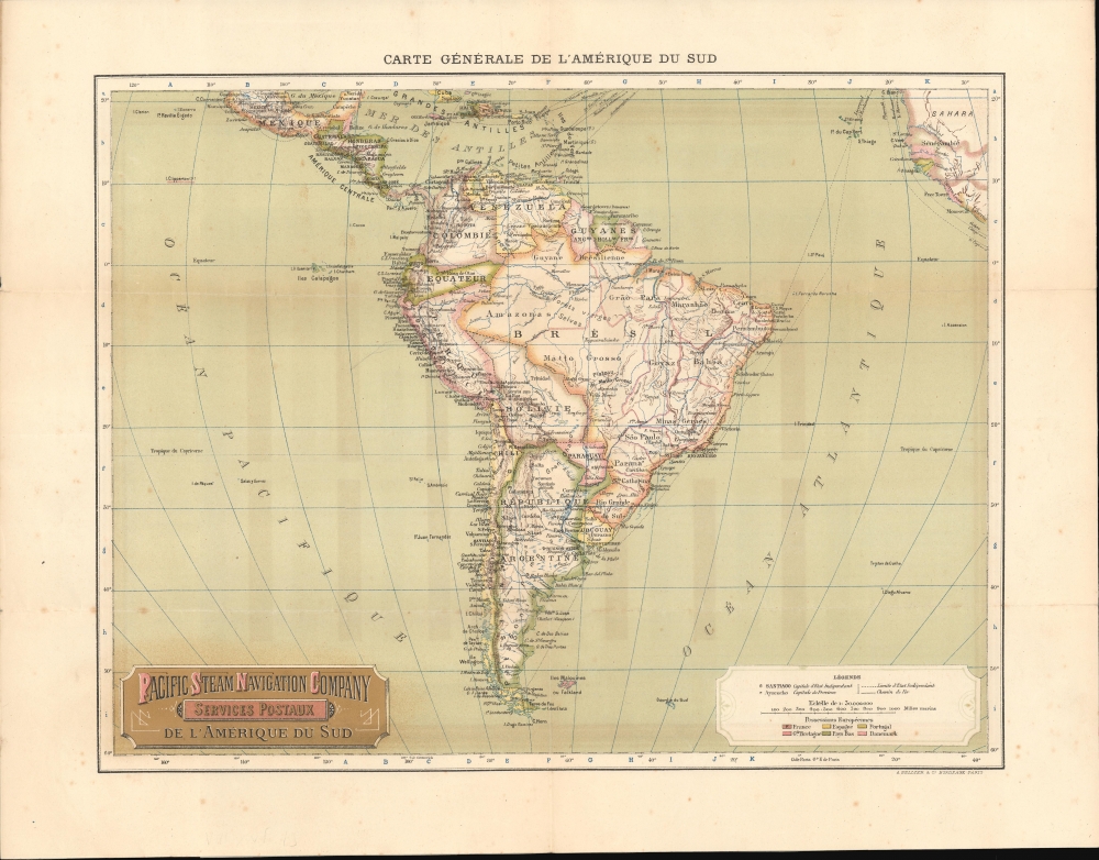
A curious, unrecorded separate issue 1894 French map of South America, printed in Bordeaux by A. Bellier for the Pacific Steam Navigation Company (PSNC), a pioneer in using steamships for transporting cargo, mail, and passengers across the Atlantic.
Countries are outlined, as noted in the legend at bottom-right, including color-shading for colonial empires of Britain, France, etc. The individual states of Brazil are also outlined, and the growing rail network of Latin America is illustrated. The map includes some odd and anachronistic borders. Bolivia is unusually large, and its borders are somewhat outdated - for example, a large portion of the northern part of the country was ceded to Brazil in 1867. Other countries' borders are unusually straight and marked with dashed lines, representing disputed or undemarcated borders (though, in reality, these had generally been long settled), leading to an unusual appearance of certain countries' borders, such as Ecuador and the border between Colombia and Venezuela.
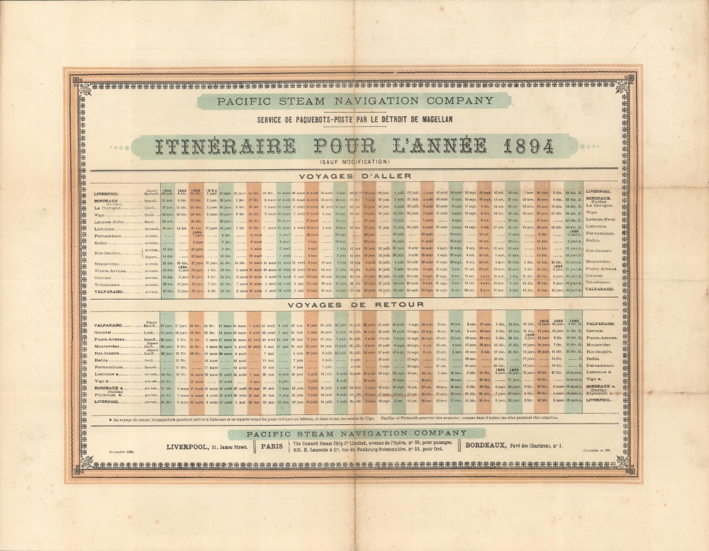
The verso includes an itinerary for the PSNC for the year 1894, with dates of departures to and from its main ports of Liverpool, Bordeaux, and Valparaiso, as well as stops in between. A complete Transatlantic voyage between Liverpool and Valparaiso took about five weeks.
A Closer Look
This unusual, ornate map, with gold printing, presents South and Central America, emphasizing shipping lines along the coasts and between the Americas and Europe. More specifically, it displays the PSNC routes from Liverpool and Bordeaux across the Atlantic, down the coast of Brazil, Uruguay, and Argentina, before rounding the Straits of Magellan and heading up the west coast of South America, stopping at many ports along the way. The map suggests service further north to Mexico's Pacific ports. However, this seems to have been ambition more than reality, or perhaps it indicates the service provided by another shipping company (as appears to be the case with lines between the Caribbean and Europe).Countries are outlined, as noted in the legend at bottom-right, including color-shading for colonial empires of Britain, France, etc. The individual states of Brazil are also outlined, and the growing rail network of Latin America is illustrated. The map includes some odd and anachronistic borders. Bolivia is unusually large, and its borders are somewhat outdated - for example, a large portion of the northern part of the country was ceded to Brazil in 1867. Other countries' borders are unusually straight and marked with dashed lines, representing disputed or undemarcated borders (though, in reality, these had generally been long settled), leading to an unusual appearance of certain countries' borders, such as Ecuador and the border between Colombia and Venezuela.
The verso includes an itinerary for the PSNC for the year 1894, with dates of departures to and from its main ports of Liverpool, Bordeaux, and Valparaiso, as well as stops in between. A complete Transatlantic voyage between Liverpool and Valparaiso took about five weeks.
The Pacific Steam Navigation Company
The Pacific Steam Navigation Company was founded in London in 1838 by William Wheelwright, a Massachusetts man with experience sailing the coasts of South America, who had been working towards establishing such a company since 1835. The company began operations in 1840 with two steamships and quickly expanded, operating up and down the coasts of Chile and Peru and eventually points further north. Service extended as far as the Panama Canal and Panama City by 1846, just in time for the California Gold Rush, which was a boon to the company. Eventually, it would beat out the Panama Canal Railroad-linked Central American Steamship Line and put it out of business. In 1852, the British government gave the PSNC a contract to handle mail along the Pacific Coast, another major advantage over competitors. In 1868, the company added Transatlantic mail services, leaving from Liverpool and stopping at Bordeaux, Lisbon, and the Cape Verde Islands. From 1877, Transatlantic passenger service was offered; the same year, mail service was extended to Sydney, Australia. The PSNC was known to maintain a high standard of service and luxury for its passenger service. Between 1905 and 1910, the PSNC was gradually acquired by the Royal Mail Steam Packet Company.Publication History and Census
This map was issued as 'Circulaire no. 858' by the Pacific Steam Navigation Company in November 1893. It was printed by A. Bellier and Co. in Bordeaux. We have been unable to locate any other examples of this map in institutional collections or on the market.Condition
Slight toning and wear on original fold lines. Some ink bleed through.


