1522/ 1535 Waldseemüller/ Fries map of South Asia (Arabia to the Malay Peninsula)
SouthAsia-waldseemullerfries-1522$3,000.00
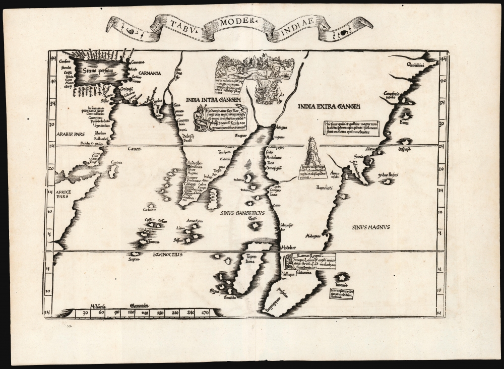

Title
Tabu. Moder. Indiae.
1522 (undated) 13.25 x 17.5 in (33.655 x 44.45 cm)
1522 (undated) 13.25 x 17.5 in (33.655 x 44.45 cm)
Description
This is Laurent Fries' edition of the earliest acquirable modern mapping of South Asia. While the topography and place names are faithfully drawn from Martin Waldseemüller's map of 1513, Fries' map also includes evocative woodcut illustrations and descriptive text drawn not from the 1513 Ptolemy, but instead from Waldseemüller's 1516 Carta Marina. Consequently, the geography shown here was thoroughly modern.
A Closer Look
The map embraces the whole of the Indian Ocean: visible in the west are the horn of Africa, the eastern and southern coasts of Arabia, and the Persian Gulf. Farther east, one encounters Persia, an exaggerated Indian Peninsula, and an early depiction of the Malay Peninsula. The map is one of the first to depict the many islands of the Indian Ocean, most notably showing Sri Lanka (Tragana) and Sumatra (Taprobana). The eastern part of the map includes the Sinus Magnus, although the so-called 'Dragon's Tail' forming the eastern shore of that 'Great Bay' is not included.Arabia and Persia
Apart from the very general world maps, this map contains the only modern depiction of the Arabian Peninsula in Fries' work. (The map dedicated to the Arabian peninsula is derived from 2nd-century geographical knowledge.) In presenting modern Arabia, it is preceded only by the 1513 Waldseemüller. The map gives coastal placenames from the mouth of the Euphrates River, down the coast of the Persian Gulf, and around the peninsula as far as Aden. Likewise, the Persian coastline is detailed as far as the Indus River.India Within the Ganges
This map and its 1513 precursor were the earliest specific maps to focus on a modern Indian Peninsula. The present work adds to its 1513 topology the text and imagery found on the 1516 Waldseemüller: a depiction of the enthroned king Vijayanagar and a lurid depiction of a woman committing sati (self-immolation) while a devil prods at the flames (a western, Christian commentary on the act).India Beyond the Ganges
The peninsula extending southwards beyond the Indian peninsula, here, is not to be mistaken for the 'Dragon's Tail' to be found on Waldseemüller's world maps; it is instead based on the depiction of the Malay Peninsula found on the Cantino Planisphere, itself probably derived from Arabic sources. Placenames such as 'Maitabane' (Martaban) and 'Mallaqua' support that interpretation, as does the island Timonia beyond the peninsula (Pulau Tioman, a place visited by Arab and Malay traders). A seated king pictured at the southern part of the peninsula appears in the kingdom of Lamai, thought to be a corruption of the 'Lamma' kingdom or the Lan Na Kingdom. Further to the north, a mountain is illustrated, and the text confidently suggests that diamonds and other precious stones could be found in those mountains - the area is, in fact, rich in gems. Another text claims the presence of roosters and hens with no feathers but instead bearing wool as fine as that of the best sheep. The ocean to the east, 'Sinus Magnus', retains the name of Ptolemy's Great Bay, but it is left open both to the East and to the speculation that it may be part of a larger ocean than Ptolemy had conceived. The peninsula Fulicandora represents the earliest effort to map what would become known as Indochina.From the Most Modern of Waldseemüller's Sources
Most of the maps appearing in Martin Waldseemüller's 1513 edition of Ptolemy were the canonical Ptolemaic maps, showing the areas they depicted as they were understood in Europe during the 2nd century. A separate section of Tabulae Modernae was included to bring the work up to date for the 16th century. Some of these 'modern maps' were based on 14th-15-century sources, such as the Sanuto-Vesconte Palestine and the Clavus Scandinavia. The freshest information - including that found on this map - derived from the 1502 manuscript chart of Alberto Cantino. Waldseemüller used the same source in compiling his 1516 Carta Marina, whose illustrations and text blocks Fries included in the present 1522 work.Publication History and Census
This map was first issued in the 1522 Lorenz Fries Strasbourg edition of Ptolemy's Geographia. A further edition was produced in that same city in 1525. Afterward, two further editions of 1535 and 1541 were published in Lyons and Vienne-in-the-Dauphane, respectively. The editor of the 1535 edition, Michael Villanovus (Servetus), was tried for heresy in 1553 and burned at the stake. Reportedly, Calvin ordered copies of the Servetus edition burned. Consequently, maps from the 1535 edition (of which this is a representative) are scarce. Overall, the four editions of Fries' Ptolemy are well represented in institutional collections. We see seven separate examples of the map in OCLC in this edition.CartographerS
Lorenz Fries (c. 1490 – 1531) was a German cartographer, cosmographer, astrologer, and physician based in Strasbourg. Little is known of Fries' early life. He may have studied in Padua, Piacenza, Montpellier and Vienna, but strong evidence of this is unfortunately lacking. The first recorded mention of Fries appeared on a 1513 Nuremberg broadside. Fries settled in Strasbourg in March 1519, where he developed a relationship with the St. Die scholars, including Walter Lud, Martin Ringmann and Martin Waldseemüller. There he also befriended the printer and publisher Johann Grüninger. Although his primary profession was as a doctor, from roughly 1520 to 1525 he worked closely with Grüninger as the geographic editor of various maps and atlases based upon the work of Martin Waldseemüller. Although his role is unclear, his first map seems to have been a 1520 reissue of Waldseemüller's world map of 1507. Around this time he also began working on Grüninger's reissue of Waldseemüller's 1513 edition of Ptolemy, Geographie Opus Novissima. That edition included three new maps by Fries based upon the Waldseemüller world map of 1507 – two of these, his maps of East Asia and Southeast Asia are quite significant as the first specific maps of these regions issued by a European publisher. In 1525 Fries decided to leave Strasbourg and surrendered his citizenship, relocating to Trier. In 1528 he moved to Basel. Afterwards he relocated to Metz where he most likely died. In addition to his cartographic work, Fries published tracts on medicine, religion, and astrology. More by this mapmaker...
Martin Waldseemüller (September 11, 1470 - March 16, 1520) was a German cartographer, astronomer, and mathematician credited with creating, along with Matthias Ringmann, the first map to use the placename America. He was born in Wolfenweiler, near Freiburg im Breisgau. Waldseemüller studied at the University of Freiburg and, on April 25, 1507, became a member of the Gymnasium Vosagese at Saint-Dié. Martin Waldseemüller was a major proponent of theoretical or additive cartography. Unlike contemporary Portuguese and Spanish cartographers, who left maps blank where knowledge was lacking, Waldseemüller and his peers speculated based upon geographical theories to fill unknown parts of the map. He is best known for his Universalis Cosmographia a massive 12-part wall map of the world considered the first map to contain the name America, today dubbed as 'America's Birth Certificate'. This map also had significance on other levels, as it combined two previously unassociated geographical styles: Ptolemaic Cartography, based on an ancient Greek model, and the emergent 'carta marina', a type of map commonly used by European mariners in the late 15th and 16th centuries. It also extended the traditional Ptolemaic model westward to include the newly discovered continent of America, which Waldseemüller named after the person he considered most influential in its discovery, Amerigo Vespucci. When Waldseemüller died in 1520, he was a canon of the collegiate Church of Saint-Dié. In contemporary references his name is often Latinized as Martinus Ilacomylus, Ilacomilus, or Hylacomylus. Learn More...
Source
Ptolemy, C., Geographicae Enarrationis..., (Lyons: Servetus) 1535.
Condition
Excellent. Few tiny wormholes not impacting printed image, else fine.
References
OCLC 859356737. Rumsey 10891.124 (1525) Tibbets G. R., Arabia in Early Maps, map 16, p. 41. Gole, S., Early Maps of India, 3. Suarez, T., Early Mapping of Southeast Asia, pp. 109-114, fig 41.