1824 Melish / Klinckowström Map of the Florida and the Southeastern United States
SouthernUSFlorida-klinckowstrom-1824$2,400.00

Title
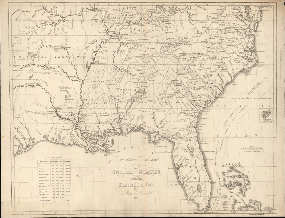
Southern Section of the United States including Florida etc. by John Melish.
1824 (dated) 16 x 21 in (40.64 x 53.34 cm) 1 : 4000000
1824 (dated) 16 x 21 in (40.64 x 53.34 cm) 1 : 4000000
Description
This is a rare 1824 Swedish map of Florida and the Southeastern United States published by Axel Leonard Klinckowström after the scarce 1816 map of John Melish. The map accompanied Klinckowström's Tocqueville-style narrative, expounding on the United States for Swedish audiences.
A Closer Look
Coverage embraces the southeastern United States from the Missouri Territory eastward, including Florida and all of the Southeast, as well as most of Virginia and the southern tips of Illinois, Indiana, and Ohio. It notes the Gulf Stream, roads, forts, cities, and settlements throughout. The overall engraving is finer than the Melish original, and while placenames remain unchanged, the map's copious annotations have been translated into Swedish. Some of these are quite interesting, such as the northernmost limit of alligators. A statistical table in the lower left details the area and population of the states and territories, East and West Florida, and the Bahama Islands. In the Bahamas, there is an island labeled the 'Center of the World'; this curious name is still in use, but it refers to nothing more than a rock projecting about 2 feet above sea level.Klinckowström in America
Klinckowström, a Swedish naval officer, was sent to the United States to assess the political situation and the viability of incorporating the recently invented steamboat into the Swedish navy. His travels were extensive, and the subsequent narrative provides a Tocquevillian overview of the United States at the beginning of the 19th century. Klinkowström discusses the important issues of the time: the acquisition of Florida, the Missouri question, slavery, etc. He also describes an audience with President James Monroe. The published narrative, Bref om de Förenta Staterna författade under en resa till Amerika, åren 1818, 1819, 1820, is best known for its finely engraved views, engraved by Carl Fredrik Akrell.Publication History and Census
The source map, by John Melish, was issued for Melish's near unobtainable 1815 A Military and Topographical Atlas of the United States; Including The British Possessions and Florida, intended to illustrate the War of 1812 (1812 - 1815). This example was engraved in Stockholm, Sweden, by Carl Fredrik Akrell to illustrate A. L. Klinckowström's Bref om de Förenta Staterna författade under en resa till Amerika, åren 1818, 1819, 1820. The narrative is unfortunately, not included, this listing is for the map only. We see about 11 holdings of this edition in OCLC, although some may be digital and not represent a physical example.CartographerS
John Melish (June 13, 1771 - 1822) was an early 19th century American writer, publisher and mapmaker based at 209 Chestnut Street, Philadelphia. Many historians consider John Melish to be the first truly great American commercial cartographer and responsible for some of the most influential maps in the history of North America. Melish was born in Scotland in 1771. As a young man he apprenticed to a Glasgow cotton merchant and in this capacity visited America no less than four times between 1798 and 1809. In 1806 Melish attempted to create his own cotton important-export company based in Glasgow, Scotland and Savannah, Georgia. Unfortunately, deteriorating relations between the United States and Great Britain resulted in the 1807 trade embargo, which all but destroyed Melish's fledgling company. In 1811 Melish finally left Scotland to permanently relocate in Philadelphia. Melish had never been truly satisfied with the quality of travel writing available regarding the new republic and so, in 1812, published his own contribution to the genre. Melish based his first major publication, the cartographically rich, Travels in the United States of America in the Years 1806 & 1807, and 1809, 1810 and 1811, on the copious notes taken during his own travels as a cotton merchant. Travels enjoyed an immediate success and even caught the eye of Thomas Jefferson, then President, who sent copies of the work to friends in France and Italy. Partially in an attempt to illustrate his own travels and partly in response to a general need for good cartographic materials, Melish turned to map publishing. By 1814 he was styling himself as a "Geographer and Map Seller" and had published several independent maps, geographies and gazetteers. Melish's most important work is most likely his iconic representation of the United States first published in 1816, Map of the United States with the contiguous British and Spanish Possessions. This visionary large format map was the first American commercial map to show the United States extending from coast-to-coast in a remarkably prescient expression of the Doctrine of Manifest Destiny. Melish died suddenly of unknown causes in December of 1822. He is buried in Philadelphia. (Carter, E. C., Surveying the Record, pages 40 - 49. Ristow, W., American Maps and Map Makers, pages 110-115. 143, 154, 166-168, 191, 246, 281, 446. Wolfgang, M.E., "John Melish: An Early American Demographer." Pennsylvania Magazine 82 (1958): pages 65-81.) More by this mapmaker...
Axel Leonhard Klinckowström (February 25, 1775 - June 7, 1837) was a Swedish Baron active in the late 18th and early 19th century. Klinckowström was born in Stockholm, the eldest son of Baron Thure Leonard Klinckowström. Although born with an artistic temperament, he he was nonetheless pressured by his ambitious father towards a military life. He joined the Swedish navy as an ensign at 17 and rose, in the course of a long career, to the rank of Lieutenant-Colonel. It was most likely Klinkowström's skills as an artist that lead his superiors to send him to America. Between 1818 and 1820, Klinkowström traveled to the United States to investigate the American invention of the steamboat and assess its military potential for the Swedish navy. During his American tour Klinkowström composted some 25 illustrated letters which were published in 1824, roughly four years after his return to Sweden, as Bref om de Förenta Staterna. The compilation not only offered practical advice for the military, merchants, and gentleman travelers, but contained numerous aquatints based on Klinkowström's drawings and offered a Tocqueville-esque commentary on American culture. Learn More...
Carl Fredrik Akrell (January 13, 1779 - December 11, 1868) was a Swedish military cartographer and engraver active in the early 20th century. Akrell was born in Uppsala, Sweden to a middle class family. He joined the military as a young man and exhibiting proficiency with mathematics was assigned to the survey department where he worked under Gustave Wilhelm af Tibell. He participated in the fortification of the Stockhom archipelago and fought with distinction in the battles of Gross-Beeren, Dannewits, and Leipzig. Following a distinguished showing in the battle of Leipzig, Akrell was honored as a "Knight of the Sword" and adopted into the nobility. In time Akrell attained the rank of Major General. Cartographically Akrell is best known for his engraved maps of Stockholm and the aquatints he etched for Jean Baptiste Le Chevalier's Trip Propontiden and Black Se and Axel Leonhard Klinckowström Bref om de Förenta Staterna. Learn More...
Source
Klinckowström, Axel, Bref om de Förenta Staterna författade under en resa till Amerika, åren 1818, 1819, 1820,(Stockholm: C. Müller) 1824.
Condition
Good. Older repair of closed tear, bottom center. A few other minor stabilized tears, limited to margins.
References
National Gallery of Art, 2015.25.4.3. OCLC 78911608.